

Snow in DC region could impact schools, morning commute Tuesday

DC weather: Tuesday snowfall forecast
FOX 5 meteorologist Mike Thomas delivers the latest weather forecast.
It has been a bit of an odd winter when it comes to snowfall here in the D.C. region, which has received just under eight inches of snow so far this season.
We have had three notable measurable snow events; one in December and two in January. All of these were events that generally overperformed in the area, giving us more snow than expected.
Can that trend continue with the winter weather expected in the D.C. area Tuesday?
That is a very tough call to make.
Nor'easter to blast snow along I-95
The storm is going to be a strong one, intensifying into a nor’easter as it pushes north of the D.C. region.
Parts of interior Pennsylvania, New York City, and New England could get over half a foot to a foot of snow as the storm intensifies off the eastern coastline.
READ MORE: Maryland snow: Several inches of snowfall possible Tuesday, Winter Storm Watches issued
READ MORE: Winter weather in DC, Maryland & Virginia: How much snow have we seen?
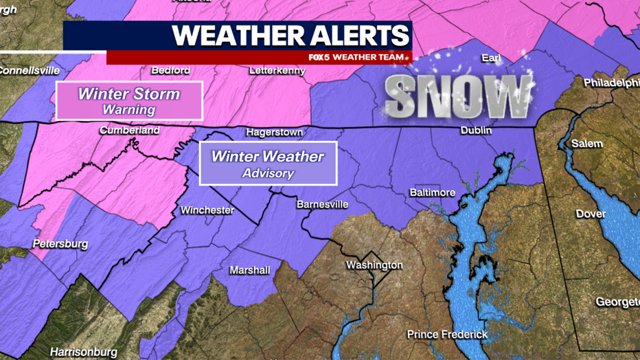
At one time, this storm was expected to pass far enough to our north that our area would be looking at only rain. However, trends through the weekend have shown the storm drifting farther to the south, allowing enough cold air to spill around the storm on the back side to change rain over to snow for a period of time on Tuesday morning. Enough so that winter weather advisories were issued for much of our region north of the Washington, D.C. metro area.

How much snow will DC get Tuesday?
Events like this one are extremely tricky to forecast for.
Due to the mountains to the north and west of our region, the D.C. area often struggles to pull in cold enough air as fast as weather models predict, leading to more of a mix as opposed to pure snow.
READ MORE: Potential Nor'easter eyes Boston: Major cities could see a foot of snow
This leads various models to give us a wide range of solutions. For example, the American model above shows nothing for downtown D.C., but nearly 5" up near Frederick, Maryland.

By contrast, there are some others like our Futurecast above that show a quick coating of snow, but significantly less northwest of D.C. These are what forecasters oftentimes call a "boom" or "bust" type of event.
The risk is there. We are likely to see at least some wintry mix in the morning, but confidence in exactly how much snow we could get is relatively low.

With that said, we are expecting 1-3" of snow in the advisory zone northwest of the city.
Loudoun, Montgomery, and northern areas could all see snowfall totals exceeding an inch during the Tuesday morning commute, which could make travel treacherous rather quickly.
As such, it would not surprise us to see a number of schools in this region delayed and see how the event plays out throughout the morning.
Snow in DC could make a February return. Here’s what we could be expecting
For the immediate D.C. area, while we do think we will change over briefly to some mix or snow, we do not think it will be as long as areas northwest of town, but perhaps enough to get a coating or a little more.

By the late morning hours, the system should exit to the northeast of our region, with skies clearing to some sunshine through the lunchtime hours. It will be chilly and breezy, however.
Valentine's Day weather forecast
The good news? We stay sunny through Valentine's Day!
Though temperatures will be chilly. A little more winter weather may approach our region closer to the weekend.
When news breaks, stream FOX 5 DC anytime. Get the FOX Local app on your smart TV.