Snow, bitter cold set stage for Inauguration Day

Bitter cold temperatures arrive in DMV by Monday
It is a big holiday weekend here in the nation's capital. For the first time since the second inauguration of President Bill Clinton back in 1997, both Martin Luther King Jr. Day and Inauguration Day fall on the same day. The weather story of the day though, will be the bitter cold. FOX 5's Mike Thomas has your full forecast for the holiday weekend.
WASHINGTON - It feels like it has been winter for quite some time, has it not? Hard to believe, but as of the writing of this article on January 16th, we are not even four weeks into the winter season. Spring is still nine weeks away!
Probably the reason winter has already felt so long is because of just how cold it has been. We have had our coldest start to winter since the winter of 2017-18 here in DC, seven years ago. Despite all of the cold that we have had, the coldest temperatures are yet to come.
It is a big holiday weekend here in the nation's capital. For the first time since the second inauguration of President Bill Clinton back in 1997, both Martin Luther King Jr. Day and Inauguration Day fall on the same day. The weather story of the day though, will be the cold.
In recent history, the first inauguration of President Barack Obama back in 2009 was notably cold, with a high temperature of just 30°F. The average model forecast high temperature for the upcoming second inauguration of President Donald Trump is just 26°F, though it is entirely possible that air temperatures at the time of the inauguration ceremony are even colder than this, as temperatures are forecast to fall much of the day Monday.
Many weather models are forecasting air temperatures in the upper teens to lower 20s for the Swearing-In ceremony set for noon. This would make it the coldest presidential inauguration since the second inauguration of President Ronald Reagan, who had a high of just 17°F on the day of his public inauguration on Jan. 21 of that year — as Jan. 20 was a Sunday. Notably, the air temperatures around the time of his Swearing-In ceremony was just 7°F.
The cold will grab the headlines, but the whispers of the potential for snowfall have been heard as well. Excluding the threat for some scattered snow showers across the D.C. region Thursday evening, there are two other threats for some accumulating snowfall across the D.C. region.
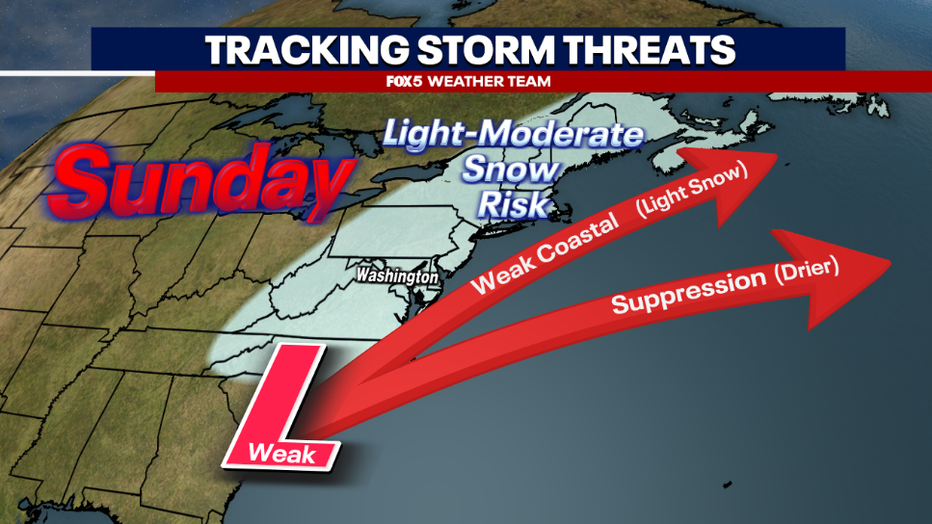
The first threat is actually ahead of Inauguration Day, on Sunday afternoon into the evening hours. An arctic front will pass through the region early in the day on Sunday. Along this front, there is the potential that a weak wave of low pressure could develop, and push northward along it.
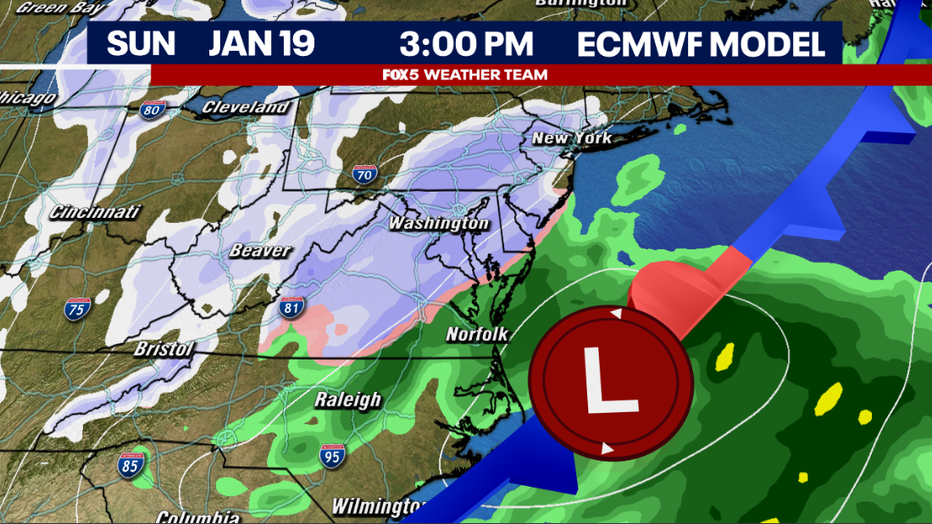
This would overspread some light snow across the DC region, with the potential for 1-3" in some areas. The strength of this wave of low pressure is still heavily up for debate though.
The upper bound of the weather models suggest that a more widespread 2-5" is possible, while there are still some models that keep the storm weak and offshore and give us nothing at all. We will need to continue to monitor the latest data for forecast adjustments here, but just know that accumulating snow is a possibility on Sunday afternoon and evening.
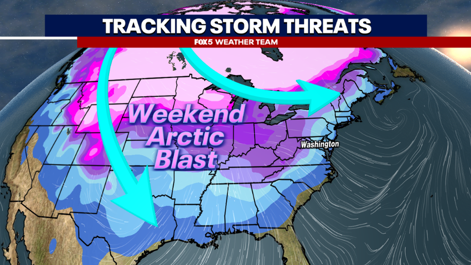
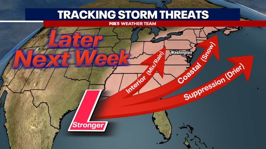
The second chance comes during the latter half of the next week. Cold, dry air will be entrenched in the D.C. region for much of the early week. This cold air will begin to vacate the region during the latter half of the next workweek, through the following weekend.
When such strong arctic air begins to pull back towards the north, you always have to be on guard for a storm to develop as milder air and moisture push northward in its wake. Unfortunately exactly what this could mean for our region is still a bit of a mystery.
Some models do suggest the possibility of snowfall, but others suggest colder air lingers and any storm threat that develops again gets pushed well out to sea. Still, others suggest a faster warm up, and that would bring the possibility of more mix or even just rain. All these solutions are on the table, just know that it is a time frame we are keeping an eye on in the week ahead.
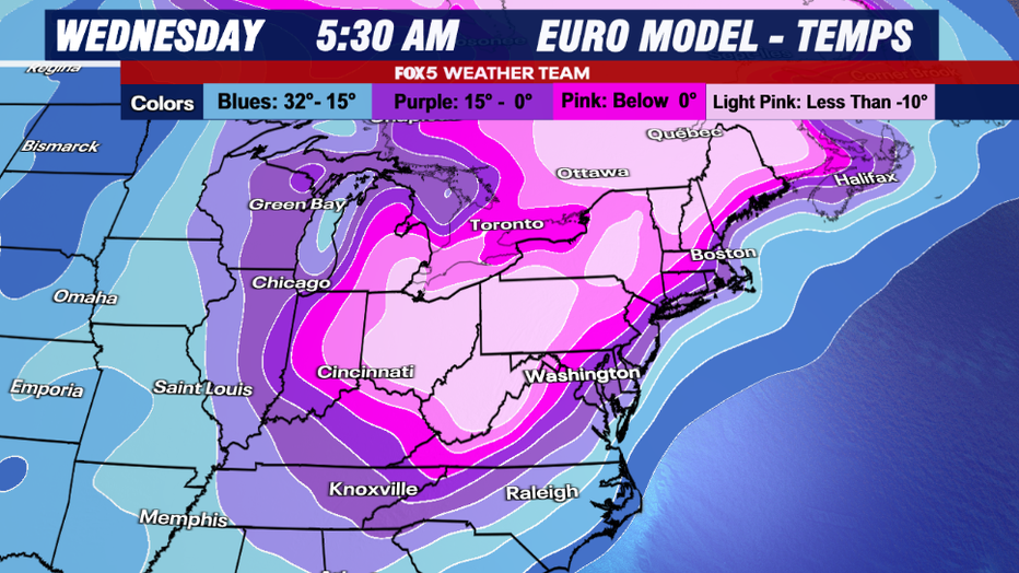
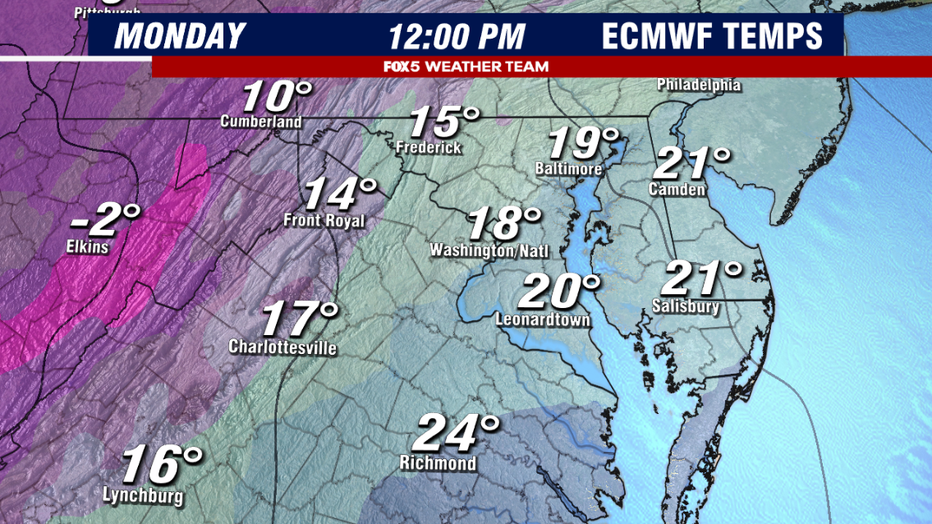
While there is a great degree of uncertainty with that system, the is a lot more certainty on what comes during the early workweek...not just what will likely be the coldest cold air outbreak of the winter, but the coldest air since December of 2022.
During that cold air outbreak just before Christmas, D.C. saw its air temperature drop into the single digits for the first time since January of 2018. Coincidentally, our current January has also been tracking as the coldest since 2018.
For the upcoming outbreak, weather models suggest not just one, but two mornings where widespread single digit lows are favored. Tuesday and Wednesday mornings could even be subzero in our western suburbs. Dulles Airport has not seen a subzero reading since January of 2019.
This intense cold, which has its origins in the snow covered plains of northern Siberia, will peak in the D.C. region on Tuesday, where high temperatures will struggle to make it into the lower 20s in most locations, before moderation is forecast into the end of the week. 40s should return to the DC region by next weekend.