

Icing threat continues tonight to the northwest; snow threatens DC Thursday
WASHINGTON - The second half of the winter has been anything but quiet. Despite only 4.7" of snow here in Washington this winter, the better part of the last month has brought us multiple winter threats each and every week, and this week looks to be one that will continue that trend, through not always in the form of pure snow.

FOX 5 Weather forecast for Monday, February 15
Mike Thomas has the FOX 5 Weather forecast for Monday, February 15.
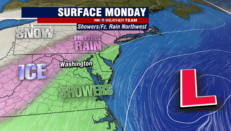
Fresh off Washington, D.C.'s first ice storm in over a decade, the threat for freezing rain returns to parts of our region later this afternoon and evening.
Unlike this past Saturday though where the immediate metro area dealt with a lot of icing, todays event should primarily be confined to northwestern zones.
Mostly the panhandles of Maryland and West Virginia. Temperatures in the D.C. region will be cold...but not quite cold enough for anything other than liquid rain closer to the I-95 corridor.
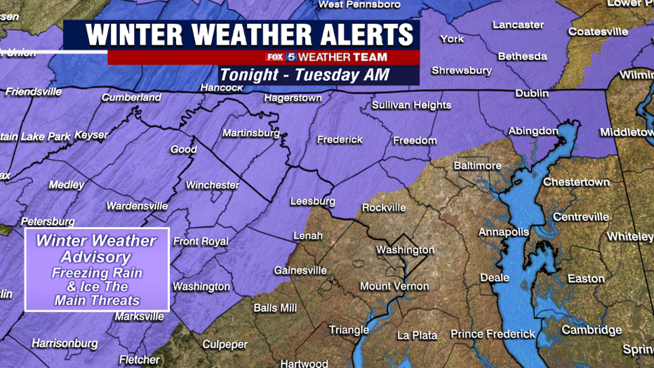
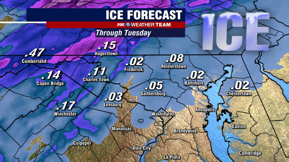
This morning the National Weather Service issued winter weather advisories for many of these northwest zones starting around 5pm tonight and lasting through the overnight hours.
These are the zones that will have the best chances of seeing patchy icing tonight. Travelers in these zones should be extra cautious, as it only takes a very little bit of ice to cause major problems.
Lesser travels and untreated side roads, overpasses, on/off ramps, sidewalks, and driveways are particularly vulnerable to icing conditions.
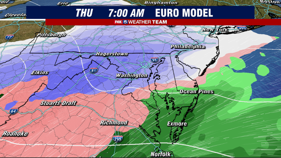
For those closer to D.C. who are still hungry for a little more winter weather and perhaps even some accumulating snows, the day you will want to carefully watch is Thursday.
An area of low pressure will approach our region from the south, running into a fresh Canadian cold air mass entrenched across our region.
Snow is likely to overspread the region late Wednesday night into the early morning hours of Thursday. Several inches of snow will be possible around sunrise Thursday.
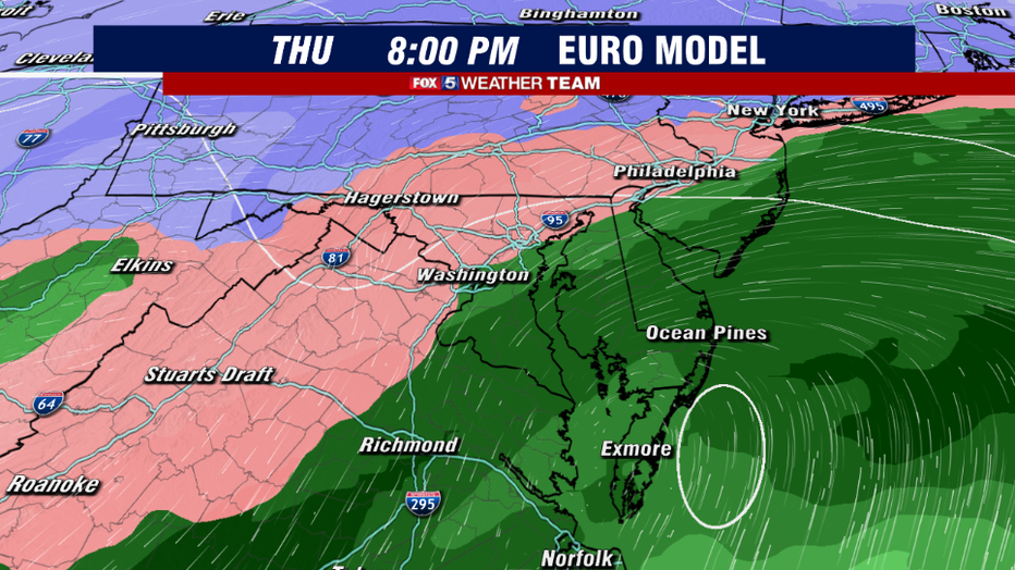
Beyond that point though, we are likely to see this storm system do what many storm systems have done here in Washington this winter, which is transition over to sleet, mix, and eventually a plain rain throughout the daylight hours of Thursday.
Much like other events here this year, this is likely to limit the threat for higher snowfall totals out of this particular system.
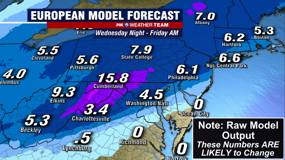
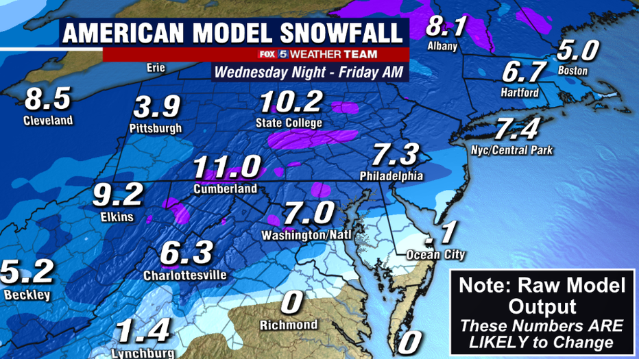
Weather models have admittedly struggled this winter to give us accurate predictions on how much snow will fall.
This is because they really struggle with situations where multiple precipitation types are possible, and the timing of when that changeover actually occurs.
As such, they typically overdo the amount of snowfall possible in areas close to where a switch to rain is possible, so take the numbers you see here with a grain of salt, and expect them to change (and likely in the lower direction) in the days ahead.
Still, at the very least it is likely the Thursday morning's commute is going to be a troublesome one.
At the very least, even sleet can cause roads to get slushy and travel to become treacherous. Start planning ahead for your Thursday plans to be impacted by this storm, with the morning hours seeing the highest impact.
We will continue to track this storm and keep you updated throughout the week. Continue to track the storm with us here online and on air for the very latest, and do not forget about that free Fox 5 Weather App as your number one source for local weather information in the palm of your hand.