

FOX 5 WINTER OUTLOOK 2021-2022: Cold At Times, But Major Snows Unlikely

FOX 5 WINTER OUTLOOK 2021-2022: Cold At Times, But Major Snows Unlikely
How much snow will the D.C. region get this winter? Here’s the FOX 5 Winter Weather Outlook!
WASHINGTON - The Highlights:
- Similar to last year, another La Niña winter is expected. This, combined with a number of other atmospheric signals, has us anticipating another winter of above normal temperatures and below normal snowfall.
- The expected storm track is such that we do not anticipate a major blizzard for the Mid-Atlantic region this season, at least not east of the I-81 corridor.
- Similar to last year, there are likely to be several mixing, sleet, and ice events. We favor 2-4 "moderate" snow events locally.
- The winter overall is expected to have a wet start, but progressively become drier than normal.
- There will undoubtedly be periods of strong cold, but we do not favor any "significant or sustained" cold air outbreaks. (No record breaking cold)

FOX 5's Winter Weather Preview
Similar to last year, another La Niña winter is expected. This, combined with a number of other atmospheric signals, has us anticipating another winter of above normal temperatures and below normal snowfall.
Forecast Review:
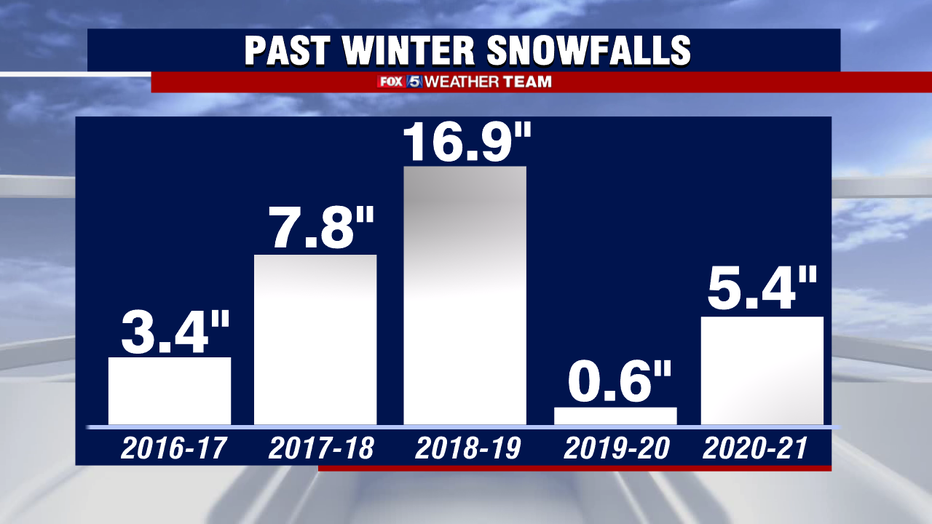
Last year was not a fun winter. It featured several instances where snowfall mixed with sleet and greatly affected snowfall totals. Weather modeling really suffered with last year's winter systems. Even some of the best models in the world struggled with storm tracks in the extended range. At least 4 or 5 times last winter, storms were in the forecast 4-5 days out with models showing totals exceeding half a foot of snow in DC, but by winter's end our largest single snow event was only a little over 2" of snow. The total for the season was 5.4" of snow, well below the average of 15.4" that DC sees in the average winter, and below our forecast range of 7-17". Still, despite the seemingly poor winter for snow lovers, the main points in the forecast were right on the money. We called for more snow than the previous season, but also below normal snowfall overall, as well as above normal temperatures, and no blizzards through the winter, and at the end of the day, that's exactly what we got. You can read last year's winter outlook and review it for yourself here!
A Changing World:
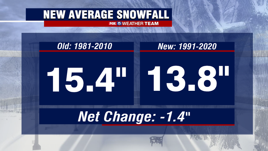
Meteorology is a science where we are constantly making comparisons to "average". But what exactly is an average winter in DC? It is not as simple as a running average of all the records we have in DC history. Instead, the scientific community runs on a 30 year average. This is done to try and account for how the climate is changing over a period of time. Thus, every decade, we get new "normals" that we compare our forecast two. Up until last year, an "average" winter was calculated using all the data from 1981-2010. As we said goodbye to another decade, we have also now said goodbye to the 80s as well. The new averages are comprised of data from 1991-2020. Compared to the old set of averages, DC's new "typical" snowfall has fallen over an inch, from 15.4" to now just 13.8" being considered normal for DC. In addition, our average winter temperature has risen by 1° fahrenheit, mostly due to some very warm winters between 2010 and 2020.
Examining The Pattern:
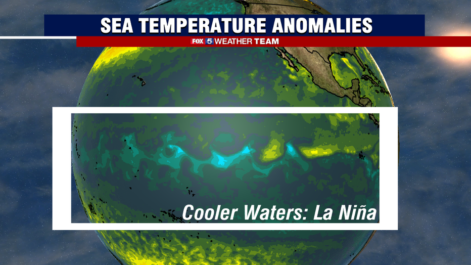
Last year's winter was characterized by what is known as a moderate La Niña weather pattern, and once again this winter, a La Niña is in the forecast. La Niña is characterized by cooler than normal water temperatures across the equatorial Pacific. While a complicated weather feature, the short story is temperature differences in the ocean temperatures can influence the global wind patterns, which subsequently impact how weather features behave over North America.
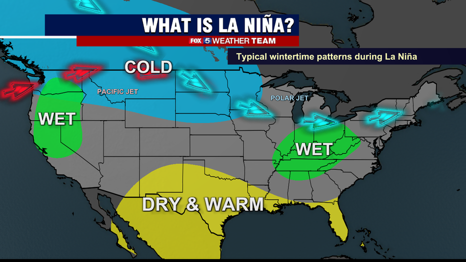
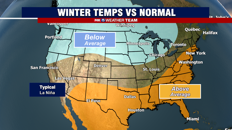
A typical L:a Niña pattern is often defined by milder than normal conditions across the southern and eastern United States, while the coldest conditions of winter get locked up across the interior of the country. The Pacific Northwest typically sees an increase in storms, which typically dip southward through the Plains states before turning northward up the Appalachian Mountains.
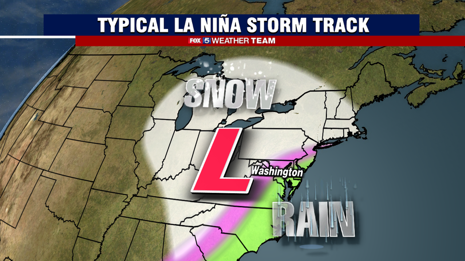
Our region is unique is just how much the land differs from the beaches and bay to the east, and the highlands and mountains to the west. A county like Montgomery County can have totally different weather through the northwestern half of the county when compared to those who live in the southeastern half of the county just a handful of miles away. This is due in large part to a steady elevation climb, with upper Montgomery County about 500ft higher than the lower county. This is one of the reason while the National Weather Service issues different advisories for those two zones. Storms that go up the Appalachian Range tend to pull in warm, southern air ahead of storm system that overtakes the lowlands rather quickly. This can lead to snow to rain, mix, or even plain rain situations as they push into our region, even after very cold days sometimes. Cold can get "trapped" over the highlands of the northwest, and thus even during La Niña winters, these area can still pick up some heavier snowfalls, and be more susceptible to icing as well.
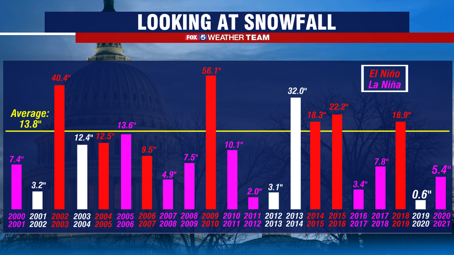
While no winter forecast will ever be perfect, the La Niña or El Niño signal can be one of the most telling when it comes to snowfall. The graph above clearly shows you why. Going back to the winter of 2000-2001, there have been a total of seven El Niño events, with all but two of them having above normal snowfall, and all of them having at least 9" of snow in DC. In fact, going back 20 years, only six winters have seen above normal snow falling in DC, and all but one of them were El Niño winters. In that same time span, there were a total of nine La Niña. Not a single one featured above normal snowfall over that 20 winter span.
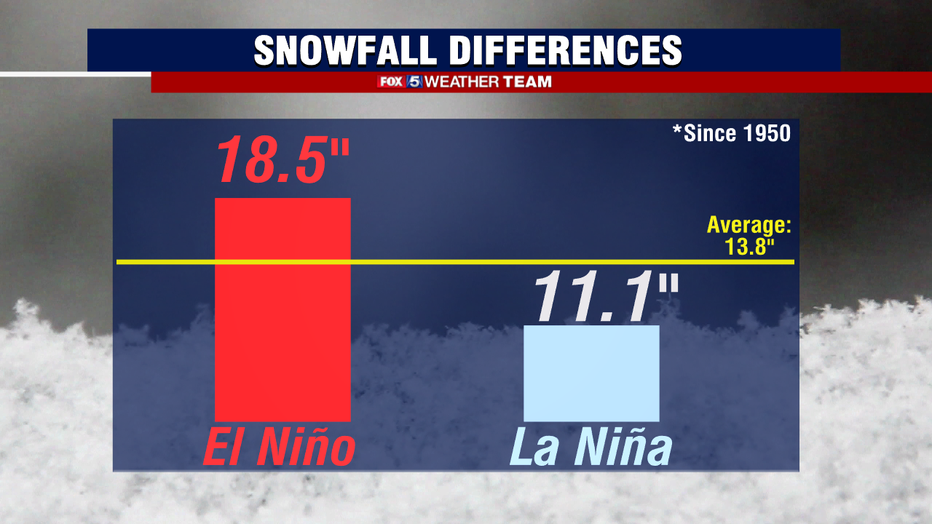
In fact, if we dive even deeper into the data, going back to 1950 when solid data gathering on El Niño and La Niña first began, there have been 26 El Niño winters, and 13 La Niña winters. El Niño years feature a more robust, southern storm track that offer higher chances of snow storms and blizzards, and the 26 have a combined average of nearly 20" of snow for the District. By contrast, the La Niña winters fall short, averaging a little over 10" of snow, with 18 of the 23 winters featuring below normal snowfall.
All this means is that the odds are not in our favor. Most La Niña year run "warm" by winter standards, and obviously that's not helpful for snow in our region. However, at the end of the day seasonal weather forecasting is not an exact science, but more of a statistical analysis of climatology, that is to say, looking at what predominate weather features are present currently, what they led to in the past, and what they could mean for the future. The atmosphere is constantly in a tug of war with itself for balance, that is why we have weather after all. No two winters are alike, and while the past can offer us a glimpse into the future, it is also very much a leap into the unknown. La Niña by itself may offer lower chances of a blizzard for example, but it does not guarantee it. A notable exception is the La Niña winter of 1995-1996, which featured an astounding 46" of snowfall for DC, the 2nd highest on record for the city. It absolutely can happen, history just tells us that it is less likely than the average winter, but not impossible.
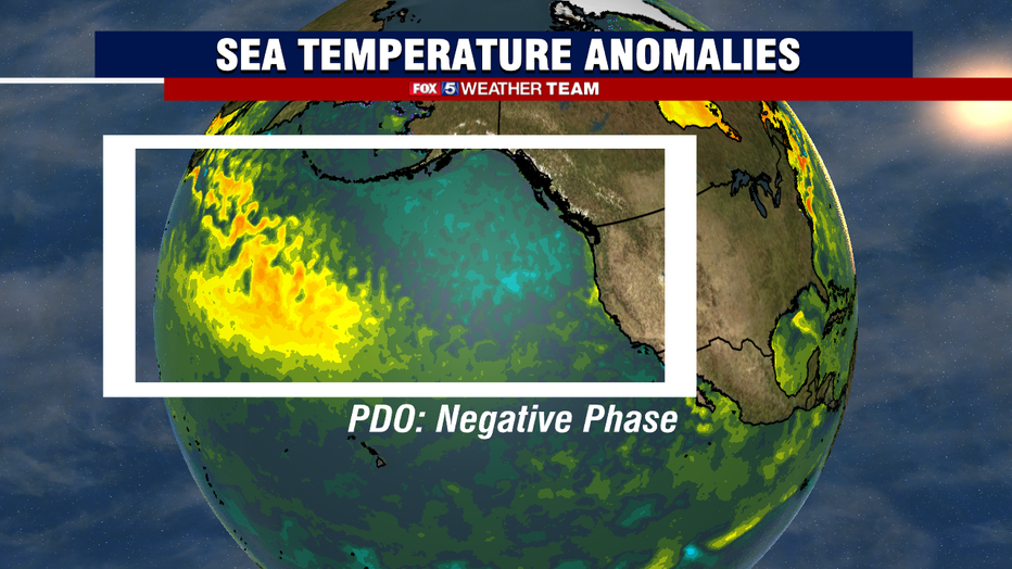
La Niña is a great signal, but we cannot base an entire winter outlook on it alone. There are a number of other factors that we look at when we make a forecast. One of the most prevalent features this season would be a strong negative signal from a feature known as the Pacific Decadal Oscillation, PDO for short. This is characterized by cold waters south of Alaska that wrap back along the western United States coastline. The ocean temperatures here can help influence upper atmospheric patterns and storms in the region, which can buckle the polar jetstream and cause impactful weather over the eastern half of the country.
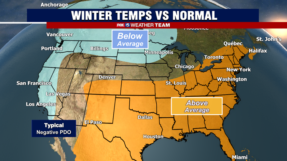
A negative phase of the PDO is pretty strongly correlated with warmer than normal winter conditions across much of the eastern half of the country. Matched with similarities with the La Niña typical temperature pattern, and you have on paper a recipe for a warm-leaning winter ahead. Another factor we looked into is the predominantly warm Atlantic Ocean, which could lead to upper level warm air intrusion on storms as they come up the East Coast, making the potential for "changeover" snow to rain, sleet, and ice events more likely. Yet another was the expanse of European and Asian snowfall so far this fall. Rapid expanse of which has shown some correlation to colder winters here, but this year the expanse has been running close to average, so no strong signals there. Solar activity is also considered, with sunspot activity starting to ramp up as we get deeper into solar cycle 25. Even still, activity is still low enough that it could occasionally promote some favorable cold air transport patterns, but honestly this forecast tool has not worked well the last several winters, so we did not put a lot of stock in it this year.
The Forecast:
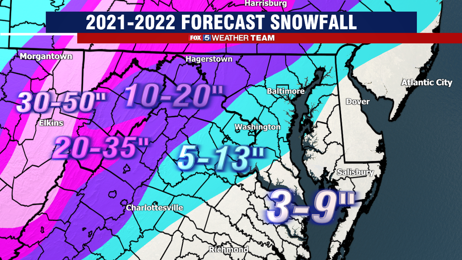
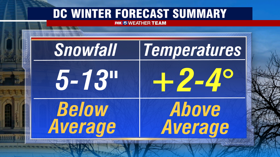
With all that said, lets hop into the numbers. Our forecast is calling for a weak to potential moderate La Niña winter, featuring above normal temperatures and below normal snowfall. Putting numbers on such a forecast is difficult, but recent history has shown that DC only exceeded 10" of snow twice in the last 20 winters when we were in a La Niña pattern. Coupled with the negative PDO, we are calling for just 5-13" of snow around the I-95 corridor for DC & Baltimore this winter, along with much of Central Maryland and Northern Virginia. As is typical, eastern zones near rivers, the Bay, and the Beaches, get less. Elevated regions get more, but we still favor below normal region wide.
Temperatures are likely to echo the trend seen in recent winters with similar pattern, and run warm relative to normal for the season overall. This does not mean t-shirt weather warm, but simply that cold spells will not be as prolonged or intense. For example, I think single digit lows will be hard to come by east of the I-81 corridor at any time this winter.
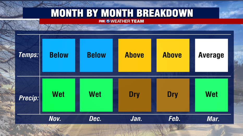
I see the winter breaking down with a bit of a fast start, and a sluggish finish. November started off quite cold for our region, with many picking up their first freeze of the year. While this middle of the month does look mild, I do think we turn cold again before the end of the month. Past Decembers with a similar overall pattern tend to run colder than normal as well, though not by a very big margin. Despite the low snow total forecast, I think the chances of some snow falling around the December holiday period is a little higher than it typically is in the average year, though keep in mind in any given year the odds of a snowy Christmas in Washington is right around 10%, not the best of odds. Asa we enter the New Year, I suspect there will be periods where the pattern goes pretty quiet, and the region will experience long stretches of chilly but dry weather. La Niña winters are not known for being particularly robust when it comes to precipitation, most run drier than normal overall. I think the odds are in our favor that winter wraps up on time this year, heading into what could be an active severe weather season in the spring as well.
To summarize as a snow lover myself, the climate signals that we look at as seasonal forecasters are not offering the best signals. The honest truth is I want to be wrong, I would love a few big snows to paint the landscape like a Christmas globe. However, the history tells me that the "bigger storms" that we have come our way this season will likely fight too much prevalent warm air intrusion and we will likely see a lot of mixing events around the city itself. That said, I do not expect to go snowless, with a few moderate, school canceling snows expected. DC has never had a snowless winter after all, and I see no reason while this year would be the first. Mason-Dixon and those along the I-81 and west are the most likely to see a couple of more sizeable snow events, while the rain-snow line battles the beltway as it often does.
Do be warned, I believe there will be a number of "false hope" storms for snow lovers as well. That is, storms which look great in the weather modeling world 4-6 days away. Where you will see images plastered on social media of weather models spitting out 10, 12, 15 inches of snow for DC five days in the future, but then will fade to much lower totals as the day approaches and weather model better capture the storm energy, track, and temperatures around the storm. We saw this a number of times last year, and no reason not to suspect that it will happen again this year.
The moral of that story is to keep it tuned here! Your Fox 5 Weather Team will have eyes on any and all potentially impactful winter systems that will come our way, and we will be keeping you informed with the latest all winter long. Of course, if you are on the go, the free Fox 5 Weather App can keep you connected to your favorite weather team 24/7 in the palm of your hand, and is a great resource to have when winter weather threatens. Remember, seasonal forecasts are imperfect, and the winter ahead will undoubtedly throw us something unexpected. And when it does, whether rain or sleet or sun or snow, count on your Fox 5 Weather Team to keep you updated with the latest!