It's back: 5 things to know about DC's next heat wave

WASHINGTON - Here we go again! By average temperature, July was the sixth hottest on record in DC. The month saw 23 days above 90°, the fourth most of all time for a single month. July alone more than quadrupled DC's 90° day count for this year, as only 5 days had been recorded before July 1.
While there's no guarantee, a hot month of July in the Nation's Capital has more times than not been echoed in August as well. With the last heat wave stretching a sweltering 13 straight days, what can we expect from the first heat wave in August? Well, here are five things to know for the next heat wave headed our way:
#5: IT WON'T BE NEARLY AS LONG.
If there is one thing that seems to separate July heat waves from those in August and September, it is their length. This is due to a number of factors, one of which is the fact that we are starting to lose our daylight. DC is already seeing about an hour less daylight than we were on July 1, and we are now losing more than 2 minutes per day as we march towards autumn's inevitable arrival.
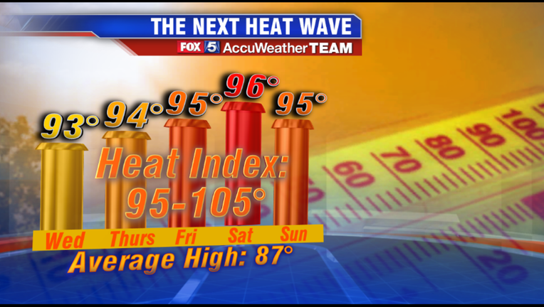
All indications are that this will be a 5 or 6-day stretch before a strong cold front brings us some relief next Monday, returning temperatures to the 80s. All in all, this heat wave should last half as long as the previous one.
#4: IT PROBABLY WON'T BREAK ANY RECORDS.
It is August in DC, and 90s are something we do see from time to time, and the majority of us are used to it-- despite average temperatures beginning to fall through the 80s. Mid 90s are a bit more rare here, as the region only sees 3 days at or above 95° on average in August.
While we may indeed see that many days before this week is over, it is unlikely that temps reach the triple digit levels needed for records to be broken at Reagan National Airport. Even the hottest weather models for the late week heat keep us below these levels, as at worst they have temperatures peaking at 97° to 98° on Saturday.
#3: HUMIDITY WILL BE THE BIG STORY.
Much like when the July heat wave peaked (and the heat index hit 112°), the bigger story with the upcoming heat will be what it feels like as opposed to the actual air temperature. Dew points by Wednesday afternoon are expected to cross the 70° threshold where they should remain through the weekend, which will give the air that thick, heavy feeling once again.
Heat index values are expected to break the century mark as the weekend approaches. Another way the added humidity will affect the forecast is actually on the evening lows. Heat will be slow to fade during the evening hours, and temperatures in the District may not fall below 80° all weekend long. This means area air conditioners will certainly be working overtime.
#2: STORM CHANCES ARE NOT GREAT.
Sometimes on a hot and humid day, there is no better feeling than a cool summer storm to knock the temperature down 10 degrees. While these chances will exist on several days throughout the heat wave, there is no day where those chances are particularly great.
The problem is that the region will really lack a strong storm "trigger" or lifting mechanism to get storms to fire. Chances are a bit higher as you head west to the mountains, where the terrain may help initiate more in the way of scattered afternoon storms on the hottest days, but most of the immediate metro area is looking primarily dry through the weekend.
#1: WE'RE PROBABLY NOT DONE YET.
While the intensity and longevity of heat will certainly wane with the end of summer fast approaching, long range weather models continue to hit at the possibility of more heat bubbling up from time to time through at least the first half of September. Several models are actually hinting at the possibility of another "mini" heat wave by the following weekend, although significantly less intense than the one in the forecast for later this week.
Still, the FOX 5 Weather Team's summer forecast for a hot second half of the summer seems to be on track.

