

DC weather: Here's what to expect for July 4 weekend
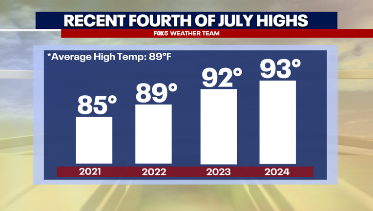
WASHINGTON - July Fourth does not have a reputation for being a particularly cool holiday, not that we would really expect that from a July holiday of course. In the last ten years, six of them have featured high temperatures in the 90s. Since the year 2000, the hottest has been 99° which we have done twice (2002, 2012) and the coolest has been 74°F (2016).
In addition to heat, it is often a holiday where we seem to have to dodge showers and thunderstorms. Seven of the past ten years have featured either rain or thundershowers reported in Washington, DC at some point in the day.
The good news is that, as things stand with one week to go until the big holiday, thunderstorms do not look like they’ll be in the forecast for the upcoming fourth of July. In fact, as far as July heat is concerned, the fourth of July holiday looks rather tame!
Timeline:
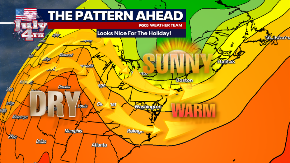
It is all thanks to a feature known as an upper-level trough which will sweep the eastern half of the country through the course of the week. During the front half of next week, the DC region will be located to the east of this feature. As winds on the eastern flank are turning out of the southwest, this is where we often see heat, high humidity, showers and thunderstorms. Some of these could be strong to severe, particularly on Tuesday afternoon.
By Wednesday though, this feature will sweep the DC region, and by the end of the short workweek heading into the holiday, we should find ourselves on its western flank. This puts us in a zone of more persistent northwest winds, bringing down less humid, and somewhat cooler air from Canada and the Upper Midwest. This means that the fourth of July has a pretty good shot at not just being sunny but also being comfortable with low humidity as well.
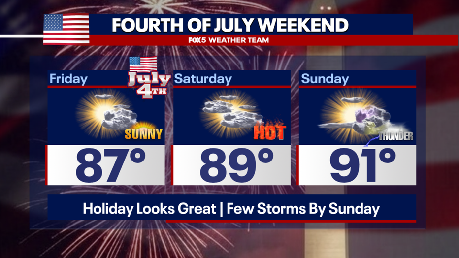
Our first look at the extended Fourth of July weekend forecast has nice conditions for the holiday Friday. Partly cloudy skies, low humidity, and perhaps our "coolest" Fourth of July holiday since 2021 with highs only in the middle to upper 80s. Perhaps most importantly, we do not foresee any weather concerns at this time. Aside from a few passing clouds, it looks like a fantastic day. Northwest winds should keep humidity low, and conditions should be ideal for fireworks viewing in the evening.
This should carry over through the bulk of the extended weekend as well. Saturday could perhaps feature more of a mixture of clouds and sunshine, but it still looks like a dry and seasonal afternoon with highs near 90°F. The hottest day of the holiday weekend looks like Sunday, with enough humidity back in the region that we cannot rule out a few pop-up thunderstorms in the afternoon, especially over mountain areas.
What's next:
Stay tuned to FOX 5 and FOX LOCAL all week long for continuing updates on your Fourth of July outlook. The weather team will be hard at work making sure you can plan your fun holiday activities without fear of Mother Nature having an unexpected interruption!