

Active storm pattern persists through middle of December

Active storm pattern persists through middle of December
FOX 5's Mike Thomas looks ahead at an active December storm pattern.
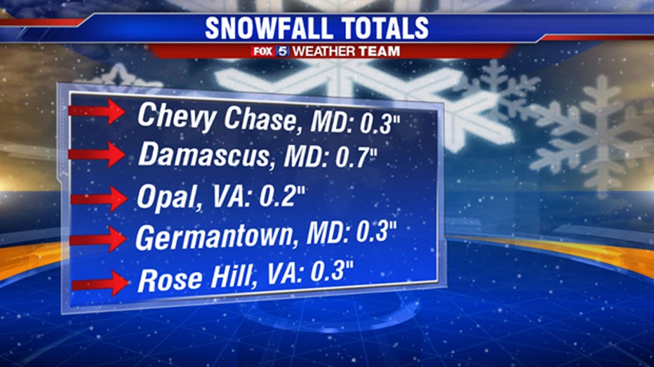
WASHINGTON - The first measurable snow event for the season wrapped up early Wednesday morning across parts of our region. Generally speaking the forecast was well done. From the snowfall totals that have rolled in so far, nobody is coming in with any surprise numbers in the higher direction. The bulk of the accumulation has been on the grass, and now that snow has stopped falling, and with sunshine and above freezing temperatures expected this afternoon, what little fell will most likely be completely gone by this afternoon.
With the return of sunshine Wednesday afternoon will come an occasionally breezy northwest wind that will help dry most of the wet sidewalks and roadways in the region. The evening commute should be a lot smoother for all in our region. If any wet spots remain, falling temperatures into the overnight ours could lead to some icy spots for tomorrow morning, but this is not expected to be a widespread issue for your Thursday morning.
Download the FOX 5 Weather App
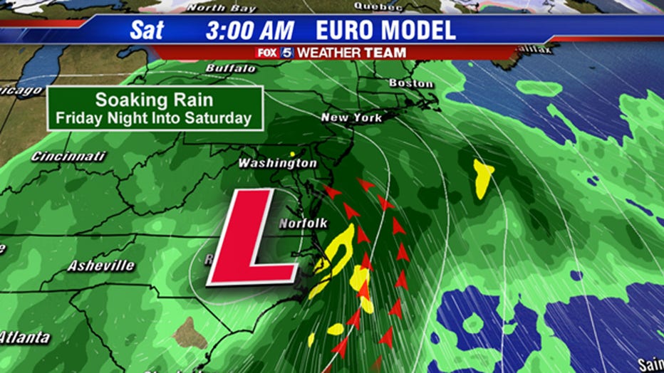
Looking ahead, the next system we are tracking starts to move into our region on Friday. During the morning hours, there will be enough cold air around that if moisture is able to push into our region early enough, it could lead to some freezing rain issues in slick spots. As things currently stand, this threat appears greatest for the far western zones at this time, primarily west of the Interstate-81 corridor. As things currently stand, the bulk of the moisture looks like it wants to hold off until later in the day on Friday, after the coldest of the air has exited our region. A soaking rain is expected Friday evening through Saturday morning as a storm system works its way up the Interstate-95 corridor.
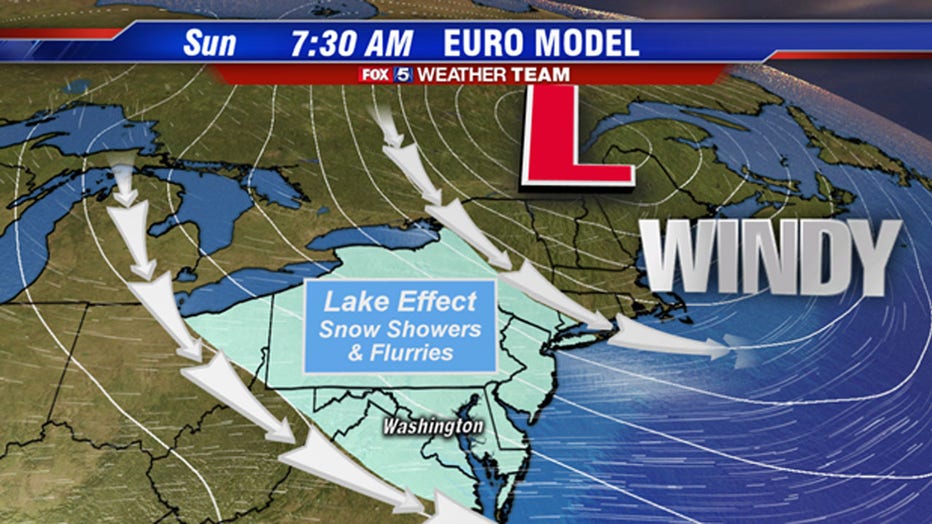
Our next chance to see some snowflakes comes after this storm passes on Sunday morning. The rain storm system from Saturday will deepen and intensify as it pushes northward. As it does so, it will kick up a pretty gusty wind here in the D.C. region on Saturday afternoon through the day on Sunday, which will bring some colder air into our region by Sunday morning. On Sunday morning itself, the direction of the wind will come directly off of the Great Lakes, specifically Lake Erie and Lake Ontario, which remain unfrozen and the water temperatures warmer than the cold air traveling over top of it. This could lead to some lake effect snow showers or flurries that could potentially make it as far south as the Interstate-95 corridor. These will be relatively light, and aside from an isolated dusting, should not cause any disruptions for our area aside from being conversational. By the afternoon, winds turning to a more westerly direction will shut off any snow showers that our out there early.
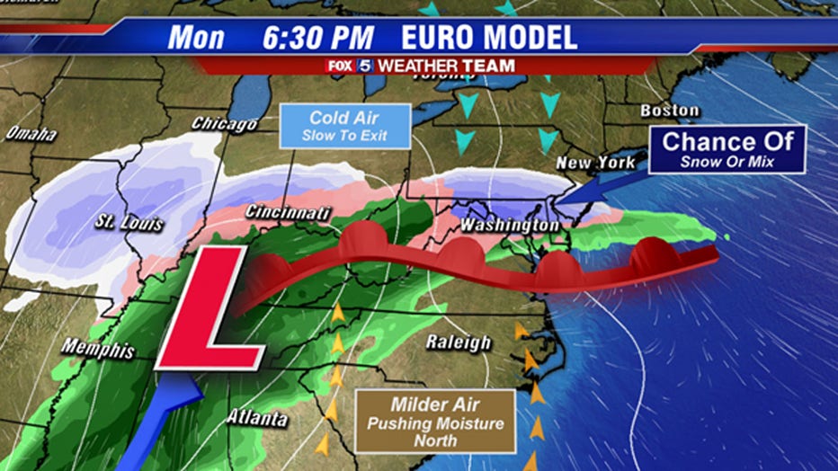
Eyes then go to the next storm system that will approach our region early next work week, in the Monday to Tuesday time frame. Details on this particular system are still a little hazy at this time frame in the forecast period, however some models like the European (shown above) give us the threat for a process known as overrunning. This is when warmer, moisture latent air is forced to rise up and cold air in place along and approaching warm front. The process can actually lead to some decent ice, sleet, and accumulating snows when they occur. If this model ends up being correct, we could be talking about something impactful during the second half of the day on Monday, including the evening commute.
However, there is a reasonable amount of model guidance out there that is farther west with the primary storm system, keeping us dry on Monday before an all rain event takes over on Tuesday. These are all possible solutions here to this system, and nothing is set in stone quite yet. It is something that you will want to keep an eye on however because if it does happen to be a winter event, it could be an impactful one. So keep it tuned to FOX 5 DC and we will be sure to keep you updated. We hope to know more about this system by the end of the workweek.
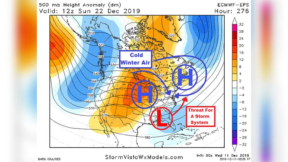
If you would like to really dive into the forecast, there is yet one more system that has winter potential that we are keeping an eye on towards the end of next week. Now, at this range weather modeling for storm tracks can be unreliable, so as a forecaster you need to jump into the upper levels of the atmosphere and look at the prevailing upper air pattern, as models are more accurate with those features than surface features when you are looking beyond seven days.
Shown above is one of these upper level charts from the most accurate model we have at this range, the European Ensemble. Based on the pattern, and those blobs of blue and orange you see scattered about, I have drawn on some surface features you we as forecasters may expect to see. Without getting into too much detail, the general theme is that the model is saying there is the chance that a storm could develop on a more southern track with some cold air entrenched to the north. This puts a little flag in our head that says "hey, keep an eye on this time period for something wintry somewhere in the East" despite not having anything concrete showing up at this time. This is the model showing us "pieces" so to speak, and we will have to wait and see if they come together in the right way for winter weather as we get closer in. Just know, that the general time frame of the weekend before Christmas is a time frame we are watching as well.
Stay with FOX 5 on the app and online for weather updates:
Get the latest FOX 5 forecast here.
Check the latest Closings and Delays
Download the FOX 5 DC News App for Local Breaking News and Weather
Download the FOX 5 Weather App
Check the latest weather radars
Check for power outages in DC region
Stay up to date with the FOX 5 Weather Team on Twitter: