

Snow, ice could hit DC region on Monday after weekend warm-up
Warm weekend ahead before chances of snow settle in on Monday
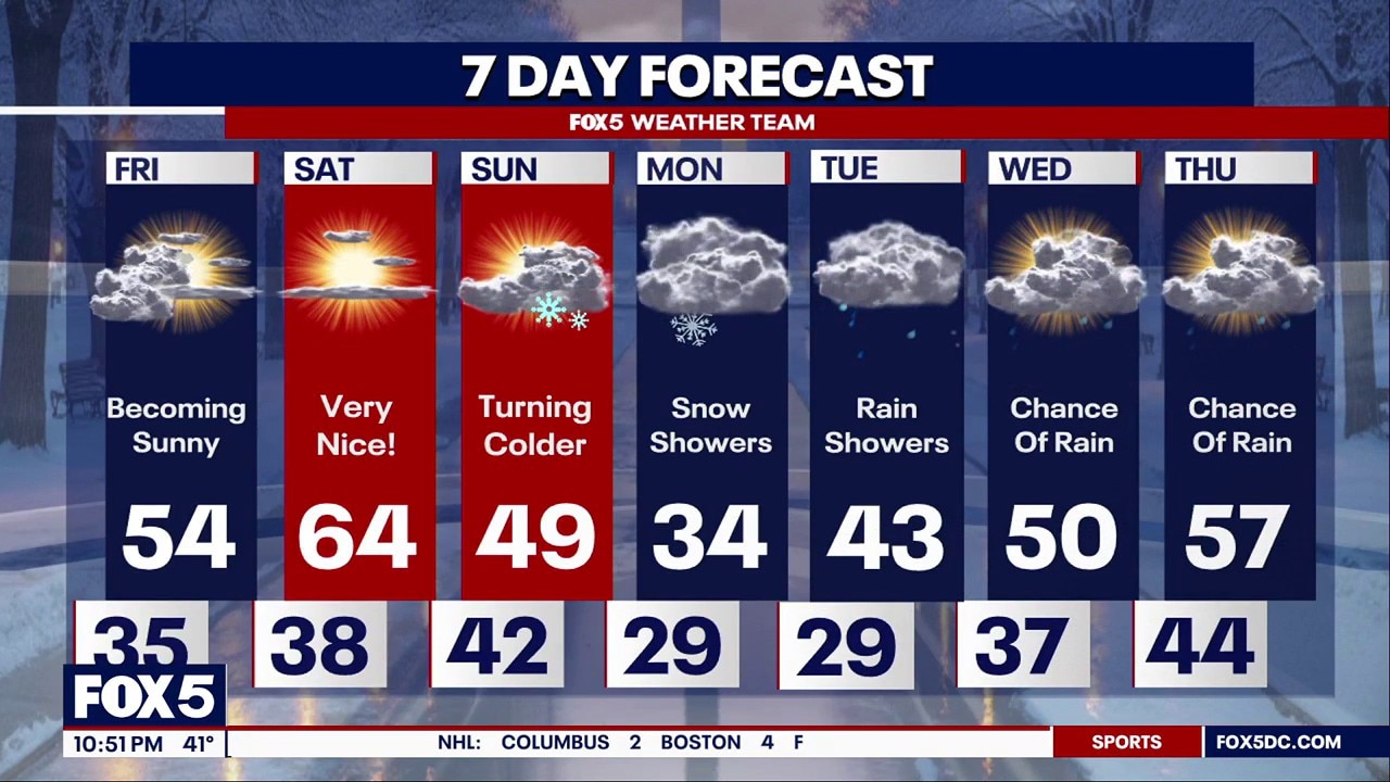
Saturday could be the warmest day of the year so far, but cold returns Sunday, with winter weather possible by Monday. Snow, mix, and freezing rain all possible, but timing and impacts remain uncertain. FOX 5 Meteorologist Mike Thomas has your full forecast.

WASHINGTON - With a little over three weeks to go, the start of spring draws near. More signs of it are starting to be seen in the weather forecast as well. Saturday looks likely to be not just our warmest day in nearly two months, but just our second 60°F+ afternoon of the year.
To give you an idea how rare that is, we typically average seven days above 60°F during the first two months of the year. In fact, it’s not uncommon for us to have seen a couple of 70°F+ days by this point in the season, something we have yet to do here in D.C.
Saturday’s warmth will be short-lived however, as a strong cold front will return the region to winter cold heading through the day on Sunday. Expect more clouds an even the chance for a passing sprinkle or snow flurry as the colder air spills back into the D.C region.
It’s not as the cold air comes into the D.C. region that the winter threat arrives, but instead as it’s leaving during the early workweek.
The threat:
Canadian high pressure drops into the region Monday morning, before quickly starting to depart during the second half of the day.
As the high departs, mid-level winds will begin to shift out of the southwest, beginning the process of bringing warm, moist air back into the region.
Cold air, however, is heavy and stubborn, and aided by an eastern wind "trapping" the cold east of the Appalachian Mountains, the warm moist air is initially forced upwards and over the colder air, a process the meteorologists called overrunning.
The questions regarding the threat during the early workweek are how quickly and how intense this mid-level wind shift that brings the moisture into the Mid-Atlantic region.
The earlier and more intense it is, the stronger the possibility that the D.C. region is dealing with an accumulating, disruptive snowfall. The slower, and weaker it is, the more likely the region is dealing with either mix, freezing rain, or rain...or a less disruptive system all together.
The scenarios:
As they often do at this range, weather models are in a debate on what scenario is most likely. One thing that they do all agree on is that cold air is strongest across the region on Monday morning.
So the faster you shift the upper-level winds out of the southwest, the more likely the event is to be a snowfall.
Models that snow a snowier solution tend to bring in moisture as early as Monday afternoon, when the atmospheric column remains below freezing through all levels of the atmosphere. They also hold off the heaviest precipitation until after sunset, when getting the snow to stick would be more likely as temperatures fall.
Other models, such as the European model, suggest that the strongest shift in the mid-level winds will not occur until much later in the day Monday, or even the overnight hours of Tuesday.
By that time, the coldest air is starting to pull away back to the northeast. While the threat for an initial mix or period of freezing rain (ice) would be possible, it would likely end as a period of chilly rain in the region as surface temperatures warmed into the DC region.
Of course, the solution may lie between these two solutions. I have seen many a similar setup here in the D.C. region start with some snow, change over the sleet, and wrap up as a period of freezing rain or rain. How much snow could lay on the ground would be heavily dependent on the initial snowfall rates are.
We will not know which solution is most likely, or how disruptive it could potentially be, until we get much closer in.
There is still the possibility that the forcing is just much weaker than expected as well. If this is the case, the moisture will be more scattered about, and less impactful overall.
Should the storm be disruptive, it would most likely impact travel during the evening hours of Monday and the morning hours of Tuesday.

Once we get past the first couple days of the next workweek, all signs point towards a much more consistently mild pattern heading into the first full weekend of the month of March.
In fact, most models are indicating that the first 70s of the year could be seen in the region as early as next Friday and Saturday, with guidance suggesting strong spring warmth continues right through the front half of the following week.
Some even show the potential for the first lower 80s of the year!
With that said, that does not necessarily mean we are done with winter just yet.
Those who have been around the D.C. area long enough know that we are rather famous for our "false springs" where we will get an extended period of late winter warmth, before winter more than often comes roaring back in once or twice more before spring settles in for good.
There are signs in the upper atmosphere that some winter cold may try to fight back into our region later in the month of March.
Whether or not this means the threat of any late-season winter weather would have to be seen at the time of course, but I wouldn’t put away the winter coat just yet, even though you may see some shorts and t-shirts make their appearance within the next two weeks.
----------------
Stick with FOX 5 here and on FOX Local for the latest forecast.
The FOX LOCAL app lets you follow the LOCAL news that matters most to you. Get the latest updates, breaking news, and videos from FOX 5 DC and any FOX LOCAL station—whenever and wherever you need them.
To provide the best experience, please know the old FOX 5 DC app will no longer be supported come May 7th, 2025.