

Heat advisory in effect across DC region Sunday as temperatures near triple digits

FOX 5 Weather forecast for Sunday, July 24
Matthew Cappucci has your FOX 5 Weather forecast for Sunday, July 24
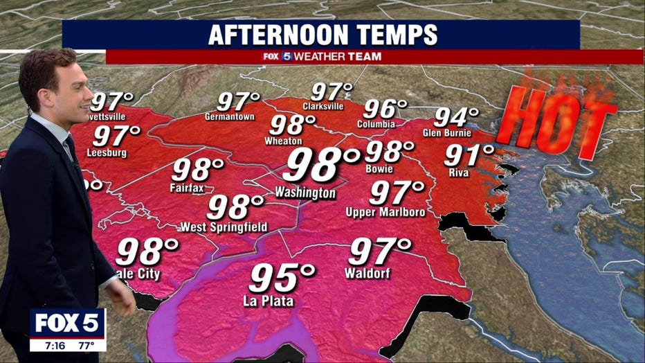
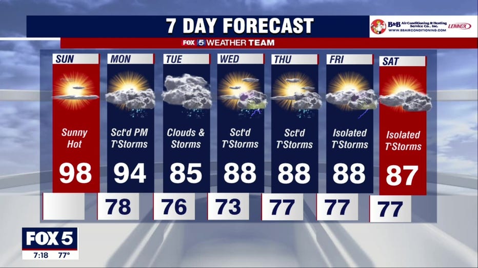
WASHINGTON - The heat wave that has been gripping the D.C. region this week will peak Sunday as temperatures across the DMV will near triple digits.
Sunday could be the hottest day of the entire summer here in the nation's capital, with temperatures in the upper 90s to near 100 degrees. A few locales may spike to the century mark, with triple-digit heat combining with a touch of humidity to brew downright dangerous conditions.
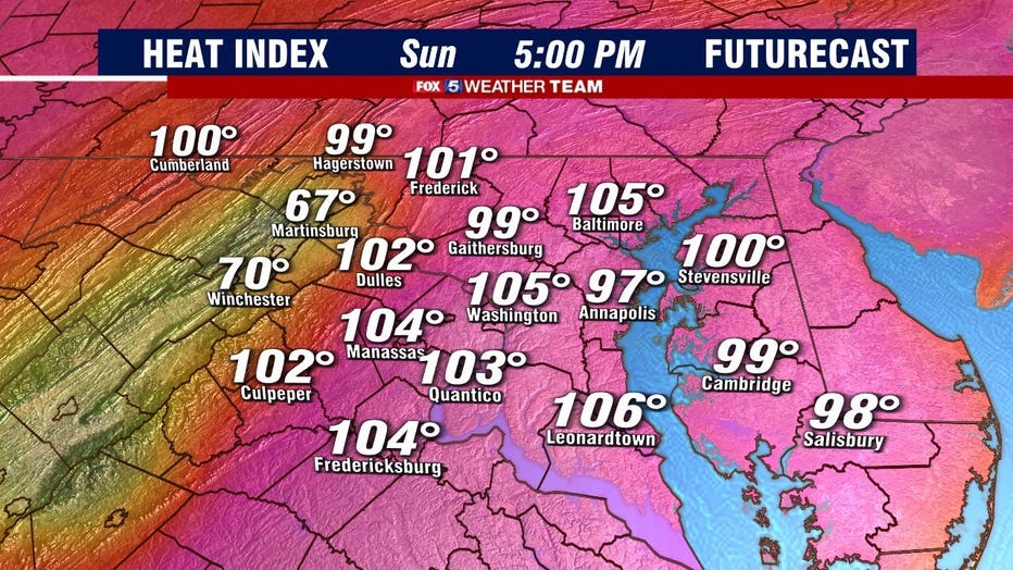
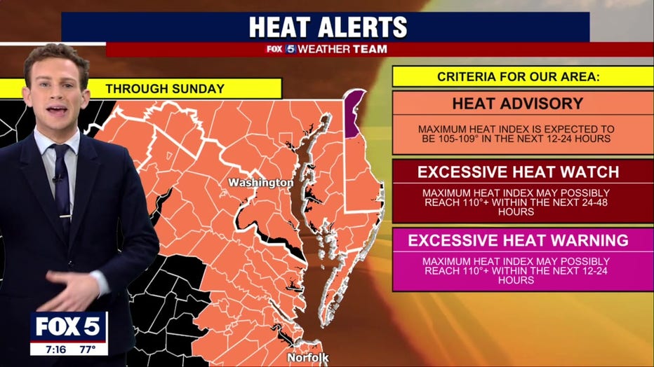
Heat advisories are in effect for the entire FOX 5 viewing area, with excessive heat warnings for some closer to the Philadelphia metro. The National Weather Service was warning residents to limit outdoor exertion during peak heating.
"Drink plenty of fluids, stay in an air-conditioned room, stay out of the sun, and check up on relatives and neighbors," they wrote. "Young children and pets should never be left unattended in vehicles under any circumstances."
Sunday has the propensity to be hotter than recent days thanks to subtly drier air in place. That's the result of down sloping, or a southwesterly breeze trucking in air that slides downhill in the lee of the Appalachians. As air descends, it heats up and dries out in a process known as "adiabatic compression." Simply stated, the stage is set for exceptional heat.
READ MORE: DC heat wave: Officials activate heat emergency, extend select cooling center hours
Theoretically, D.C. could see its first 100 degree reading since July 25, 2016. However, that's unlikely to occur. The sensor at Reagan National Airport responsible for logging D.C.'s official observation is located on the south end of the peninsula-like landmass on which the runways were erected. As a result, any southerly or southwesterly component to the breeze would pump in slightly cooler, muggier air off the Potomac, preventing temperatures from breaking out of the upper 90s.
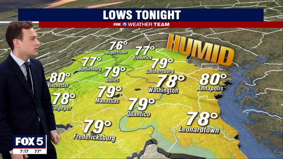
After a steamy night tonight in the upper 70s, highs will rebound into the lower 90s tomorrow before a round of strong to severe thunderstorms with gusty or locally damaging winds in the afternoon. The National Weather Service's Storm Prediction Center has placed most of the D.C. region under a slight risk for severe weather as a result.
The good news is those storms will bring a cool down Tuesday as the heat wave finally breaks and temperatures are expected to be in the mid 80s.
READ MORE: Dangerous heat wave grips DC region through weekend
TIPS FOR STAYING SAFE IN THE HEAT
- Drink plenty of fluids, stay in an air-conditioned room.
- Stay out of direct sunshine.
- Check up on relatives and neighbors.
- Young children and pets should never be left unattended in vehicles under any circumstances.
- Take extra precautions if you work or spend time outside and when possible reschedule strenuous activities to early morning or evening.
- Know the signs and symptoms of heat exhaustion and heat stroke.
- Wear lightweight and loose fitting clothing when possible.
- Schedule frequent rest breaks in shaded or air-conditioned environments when working outdoors.