

DC heat wave 2025: Extreme heat warning in effect with heat index up to 110 degrees

DC heat wave forecast for Monday June 23
A heat dome has settled over the D.C. area, bringing extreme high temperatures this week.
WASHINGTON - A massive heat dome – a stationary high‑pressure system trapping soaring heat and humidity – has parked over DC. This "lid" on the atmosphere allows relentless sunshine to bake the region day after day.
Highs are reaching the upper‑90s°F, but humidity pushes heat index values into the 105–110 °F range. Nights remain muggy, barely breaking below 70–80 °F, offering little respite for residents and raising overnight health concerns.
How long is the heat wave going to last?
Timeline:
- Monday, June 23: National Weather Service issued an Extreme Heat Warning from 11 a.m. to 9 p.m. with heat indices spiking to 110 °F
- Tuesday–Wednesday: An Extreme Heat Watch continues, with the potential for another warning, signaling that the oppressive heat is far from over.
Temperatures are expected to drop into the 80s and low 90s by this weekend.
Heat wave map
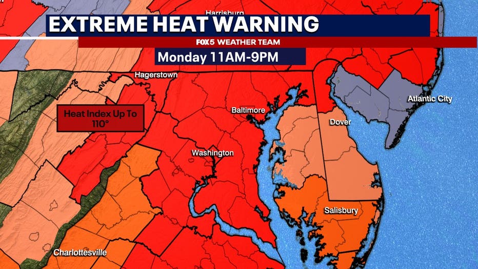
A heat warning has been issued Monday across the DMV.
How to stay cool during a heat wave
What you can do:
To combat this heat wave, D.C. has activated its Extreme Heat Response Plan and opened cooling centers, as well as made spray parks and public pools available daily from 10 a.m.– 6 p.m.
How to Stay Safe
- Hydrate constantly, even if not thirsty.
- Stick indoors from 10 a.m. to 6 p.m.
- Wear loose, light-colored clothing and use sunscreen.
- Never leave kids or pets in cars.
- Use fans or air conditioning.
- Check on elderly or vulnerable neighbors, make use of cooling centers.
What's next:
The heat dome is expected to linger through Wednesday, with temperatures gradually cooling by Thursday, though milder heat continues. Keep checking local alerts for updated warnings and heat watches.