

Super Bowl weekend snow threat possible for DC region

FOX 5 Weather forecast for Wednesday, February 9
Tucker Barnes has the FOX 5 Weather forecast for Wednesday, February 9
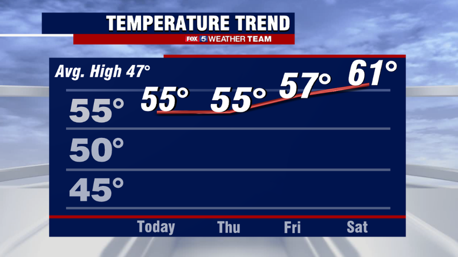
Let's start off with the good news shall we! 60° is a number the D.C. has only seen three times since the start of the new year. Before this week is out, we may add a fourth to that short list!
In fact, the D.C. is about to undergo its nicest stretch of weather of this young year so far. Since we turned the calendar over to 2022, the longest streak of 50°+ days in a row we have been able to string together here in Washington, DC has been TWO. That's it.

FOX 5 Weather forecast for Wednesday, February 9
Mike Thomas has the FOX 5 Weather forecast for Wednesday, February 9
With Tuesday hitting 50° in the city and today expected to easily eclipse it, we should easily be able to triple that streak in the days ahead. A strong area of high pressure has settled in over southern United States, turning our winds out of the south and bringing some southern warmth for our region to enjoy.
There will be ample sunshine as well, with a quiet pattern lasting through the end of the week. The warmth should peak on Saturday, with some places reaching the lower 60s.
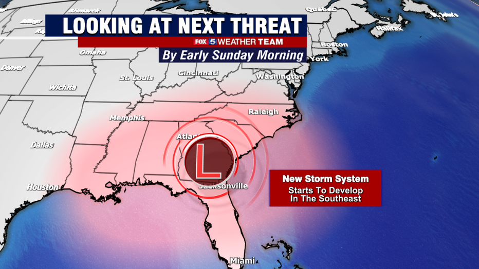
All good things must come to and end though…it is still winter after all. Still, it is hard to believe the very next day, Super Bowl Sunday, is the day we are watching for possible snow.
As the southern, warm weather high weakens and fades off the Southeast coastline, a new area of high pressure will begin to build in across the Plains, snapping our temps "back to reality" with winter cold expected all day on Sunday.
At the same time, the jetstream will dip down through the center portions of the country, with energy along this jet triggering the formation of a storm across the southern United States. The strength and track of which will drastically impact our forecast on Sunday.
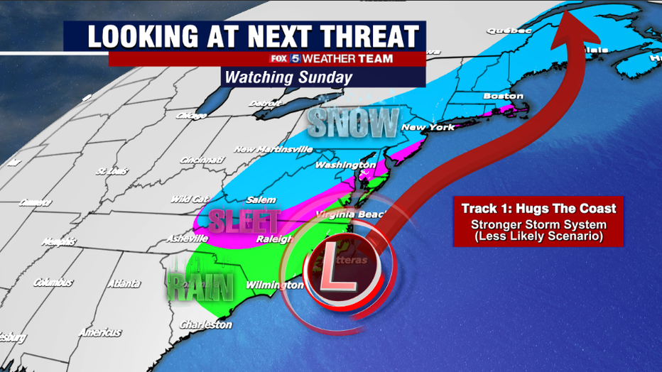
If the stop is able to deepen and develop more rapidly, there is an increased likelihood that it will turn north faster and hug the eastern coastline. While there are a number of factors needed for this to happen, it is certainly in the realm of possibility.
Such a scenario would most likely provide an accumulating, wet snow for much of the region. At this time, there are no indications that this storm would be anywhere near the scale of say, the blizzard that impacted Boston a few weeks ago.
Still though, if "worst case scenario" models are realized there would be the potential for a moderate snowstorm across the region that could impact those traveling to watch the super bowl on Sunday, with residual effects possibly lingering into Monday as well.

The American model this morning is leading the charge in the snowier risks. It shows a persistent light to moderate snow throughout the day and into the evening of Sunday across much of the region.
For those who wonder if it is possible to get and accumulating snow on Sunday when temperatures on Saturday are expected to be in the 60s, recall that our biggest snow of the season so far came the day after a 63° day in Washington, when the city received over a half of foot of snow. This model is putting down some very similar numbers.
Some may remember that is was the American model that was the first to give warning of that significant snow at the beginning of January as well, so it is not a model worth discounting. Still, we expect some changes in the day ahead, as the model gets a better grasp of the upper atmospheric energy that will power the storm.
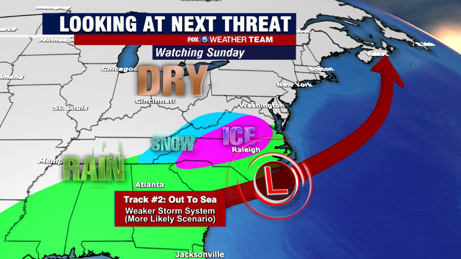
The other scenario of course is that the upper level energy actually comes in weaker than the American model expects that it will. If this is the case, the system would be less of a storm, and more of a "wave" that weakly develops over the south, and gets pushes out to sea eastward.
That doesn't mean that Sunday would be completely snowless as a frontal boundary dropping in from the northwest could still scatter about some snow showers, but without an intensifying storm system nearby to "throw" additional moisture over the incoming cold air, the impacts would be considerably less.
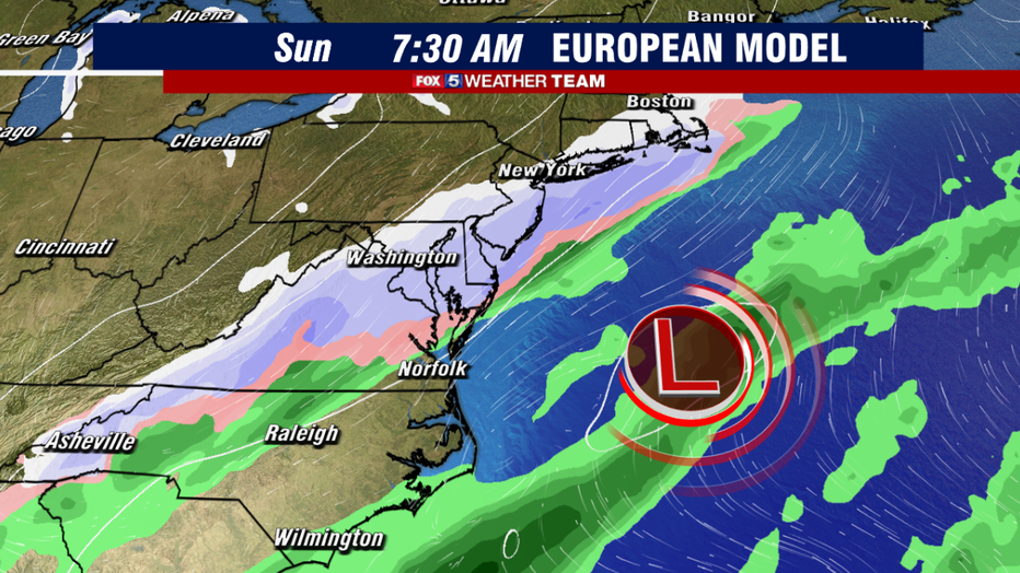
This morning's European model is the chief proponent of this scenario. Some morning snow showers scatter about the region, coating the ground in some places, as an arctic front slides across the area and interacts with some Atlantic moisture…however by the evening hours it is much drier.
It shows little impact on any making Super Bowl travel plans, and there would be no impact on the following Monday. The European model did struggle early in the winter with storm tracks, but has performed better in the last couple of weeks. It is a tough call to discount either model at this range.
While these are the scenarios as they stand this morning, it is important to note that these models are likely to both shift, whether in a snowier direction or not, in the days ahead. Weather models are not so simple that it is only the storm that matter, but all the many features that come together to make it.
As the strength and location of each of these individual features comes more and more into play in the days ahead, we will have a better idea of which solution is correct. So please stay tuned in the days ahead. Your Fox 5 Weather Team will be watching this very closely and will continually update you.
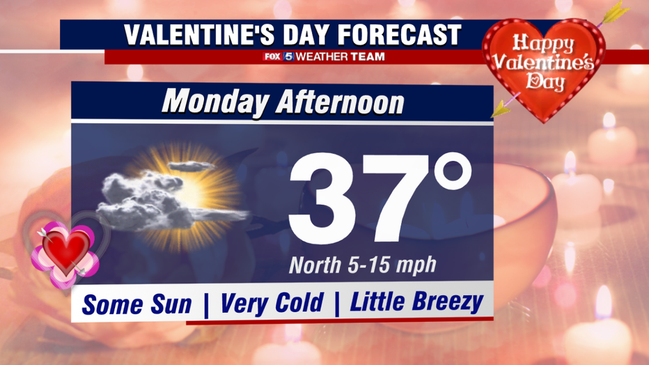
The one thing we can promise you at this stage, is that the cold returning is a virtual guarantee. Regardless of how much, or if any snow falls at all, temperatures, are expected to tumble Sunday into Monday. For those making Valentine's Day plans for that special someone, I am sorry to tell you that a romantic outdoor picnic might not be your best option this year.
A northern breeze will likely keep much of the region in the 30s on Monday. Thought the good news is that by Monday afternoon, the forecast does at least look dry.
More updates to come throughout the week. In the meantime, enjoy the nice stretch of weather that we will have!