

Sunny Monday with highs in the 90s; scattered afternoon storms possible
WASHINGTON - We wound up with more cloud cover Sunday than expected as we got sandwiched between two weather systems keeping temperatures back a bit during the day.
Download the FOX 5 Weather App
FOX 5's Matthew Cappucci says Monday we'll be working with mostly sunny skies with highs peaking around 90 degrees.
By the afternoon, a stalled front should touch off some storms. There are signs they could linger near and south of the District during the afternoon. One or two could produce gusty winds, and torrential downpours will accompany any storms. Bring the umbrella just in case.
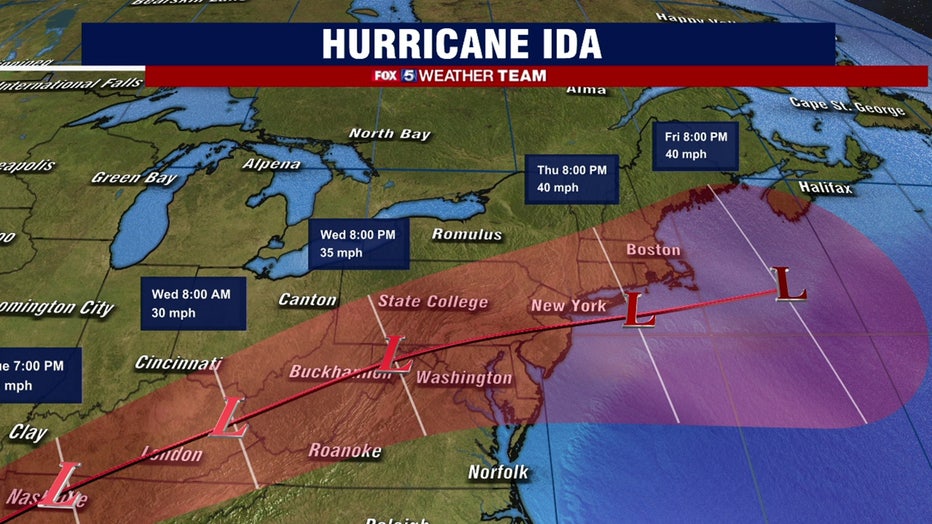
Tuesday we hang onto some more cloud cover ahead of Ida's remnants, with highs in the upper-80s. A bit of light rain may sneak in by evening. A spot thunderstorm can't be ruled out, especially est.

FOX 5 Weather forecast for Monday, August 30
Mike Thomas has the FOX 5 Weather forecast for Monday, August 30
Wednesday we could have a soaking rain from Ida's remnants, but the operative word is could. It's likely that the heaviest rain, possibly topping three inches, falls to our west, with an inch or two in D.C. There will be a sharp east to west cutoff in rainfall, so we'll have to fine-tune that forecast. A bit of severe weather can't be ruled out either.

Thursday some shower activity lingers, with highs in the lower 80s. Our reward comes Friday with glorious weather — highs may struggle to hit 80 with dry air swirled down from Canada and wall-to-wall sunshine. Similar weather Saturday.
By Sunday we start the upward climb again.

Stay with FOX 5 on the app and online for weather updates:
Get the latest FOX 5 forecast here.
Check the latest Closings and Delays
Download the FOX 5 DC News App for Local Breaking News and Weather
Download the FOX 5 Weather App
Check the latest weather radars
Stay up to date with the FOX 5 Weather Team on Twitter: