

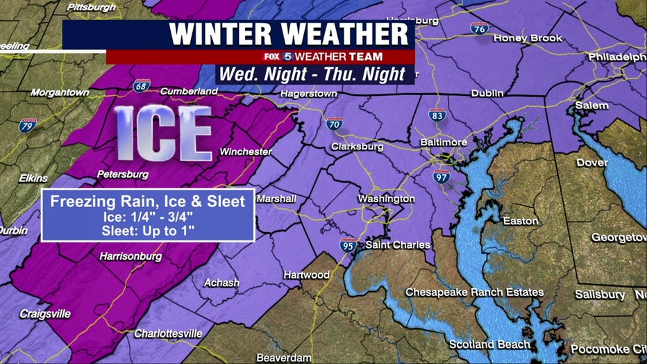
Freezing rain, ice, sleet could make for a treacherous storm across DC area early Thursday

FOX 5 Weather forecast for Wednesday, December 14
Claire Anderson has the FOX 5 Weather forecast for Wednesday, December 14 which is predicting freezing rain, ice and sleet for Thursday, December 15
WASHINGTON - The first big weather event of meteorological winter for DC, Maryland and Virginia is likely to cause a messy commute come Thursday morning for the DMV.
The DC Area's first wintry weather event of meteorological winter 2022 - explained
The storm has its origins in a massive storm across the middle of the country from earlier this week. This storm wants to push northward into Canada, but cannot due to a feature in the north called a "Greenland Block". Because of this, the storm is forced to go around it. When this feature is present, storms often take two tracks.
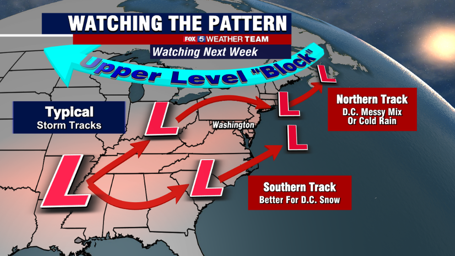
One that is far to the south, which can bring snow to the D.C. region, or one that occurs right over or just north of D.C., which can give us a mix of precipitation but typically not heavy on the snowfall amounts. Thursday's storm looks to be the latter case.
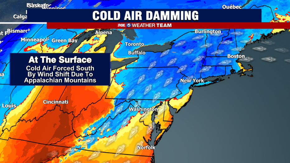
The issue when storms take this northern track is one of a divided atmosphere. At the lowest levels, cold like to settle is and gets "stuck" on the eastern side of the Appalachian Mountains, a process known as cold air damming, as the mountains act like a dam preventing the cold, heavy air from escaping…like water building behind a dam.
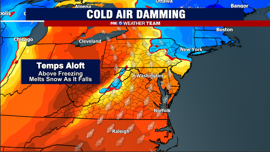
At the same time, winds shifting out of the south just above the surface (5,000-10,000 feet) will be streaming in warmer air. The above freezing air melts snowfall on its way down to the surface, however the sub-freezing air near the surface can re-freeze it prior to hitting the ground (sleet) or the cold rain can freeze on contact as it hits ground temperatures at or below freezing (freezing rain) which can form dangerous sheets of ice on area roadways.
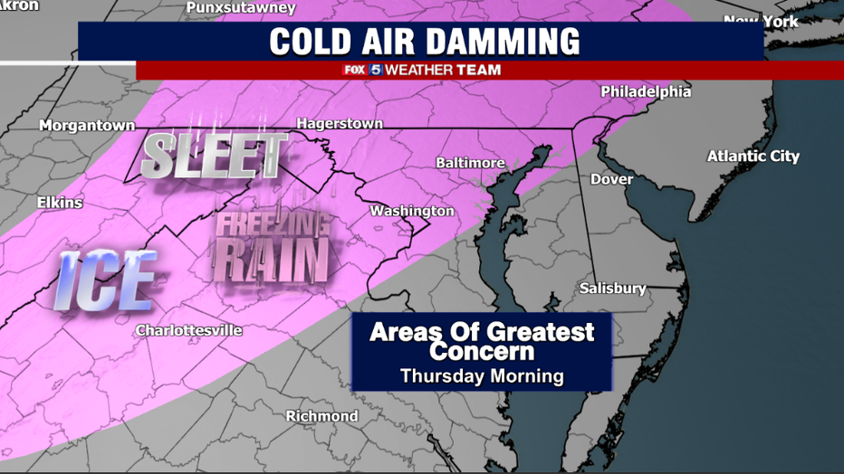
This is the primary concern for the majority of our region on Thursday, mostly during the early morning hours. While elevated areas to the far west (west of the I-81 corridor) and to the far north (north of the Mason-Dixon Line) may see some initial, minor snowfall accumulations, the vast majority of our region will be primarily concerned with other types of wintry precipitation.
Weather models are still very mixed on just how much cold air will be present at the surface, but there is the threat that the morning commute could get pretty dicey on Thursday.
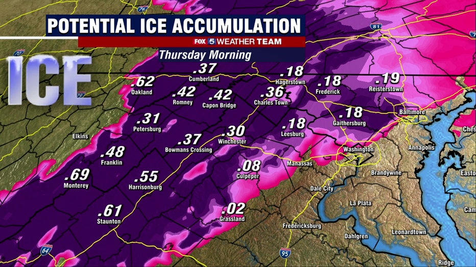
Ice is perhaps one of the trickiest thing for a weather forecaster to handle. It is heavily temperature dependent and usually those temperatures are very close to the freezing mark, where just a single degree can make the difference between wet and icy roadways.
It can be extremely difficult to deal with in terms of road treatment as well, because freezing rain falls initially as a liquid rain prior to hitting a surface. So pre-treatment is often washed off the roadways, and ice is able to develop where ground temperatures remains below freezing. While weather model, including the one shown above, do tend to overestimate the amount of ice accretion on the surface, it is entirely possible that western parts of our region could see winter storm warnings not for the threat of snowfall, but the threat of ice.
As far as timing is concerned, the biggest impacts would be focused around the sunrise hours of Thursday, when temperatures will be at their coldest.
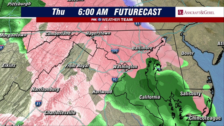
While the I-95 corridor could see some patchy icing, concerns appear to be greatest as you approach the I-81 corridor and elevated areas to the west. By the afternoon, southeasterly winds pushing in ahead of the intensifying storm will help erode the cold air stuck at the surface, and temperatures should slowly rise from the 30s and into at least the lower 40s.
By the lunchtime hours, it should just be a cold and at times heavy rain across the entirety of the D.C. region.
Models suggest that parts of our region could pick up close to 2" of rain as this storm comes through. It will be a cold and miserable day on Thursday afternoon. However the afternoon/evening commute will not have the same winter impacts that the morning commute could, as temperatures would have warmed well above freezing in most locations.
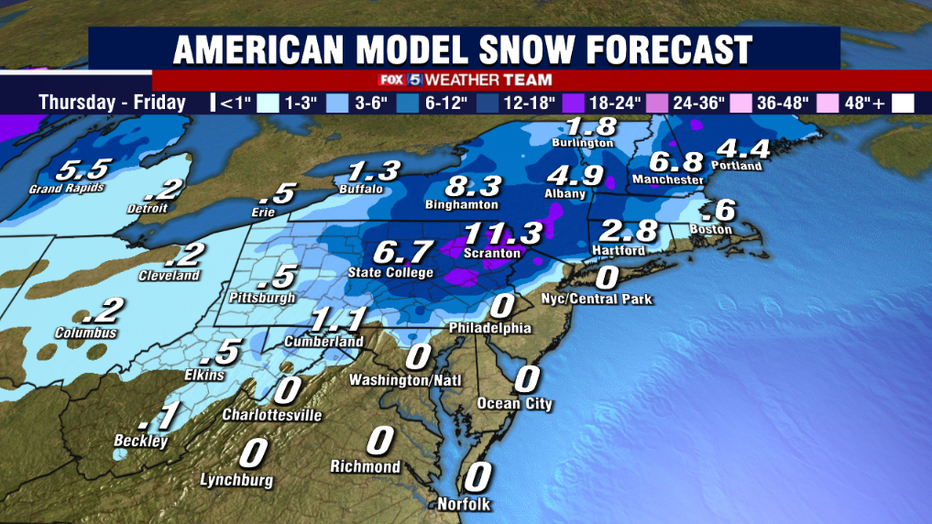
As for snowfall, guidance suggests that the areas most impacted will be northeast Pennsylvania, interior New York and New England where some areas could see over a foot of snow.
However, the model consensus as of Tuesday is that the majority of the I-95 corridor will miss out on any of the significant snows. This is setting up to be a classic interior Northeast snowstorm.
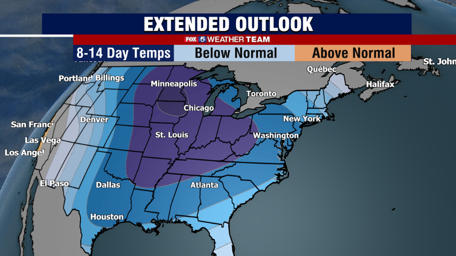
Although snow lovers will be disappointed in the near miss situation for this coming Thursday, expectations are not only that our region will see cold continue through the end of the month, but it is even expected to get stronger as we get closer to the Christmas holiday. The pattern remains very active as well.
Early model suggestion suggest early next week and then late next week both need to be monitored for potential storm risks, though it is far too early to tell is things will line up enough for a winter scenario.
One thing is certain, this winter is going to start off next week feeling much more like the middle of winter.