

Spring warmth arrives! But for how long?
After yet another chilly spring weekend in Washington where temperatures failed to make it out of the 50s, many residents in our region are tired of the chilly conditions and are ready for spring warmth to settle on in.
The longevity of this cold spell has not been exaggerated either, as only three of the previous seventeen days have featured above normal temperatures in Washington. We are finally going to put that streak to an end this week though, with several days of 70s and even some 80s ahead.

A strong storm system developing out in the center of the country will work in tandem with a feature known as a "Bermuda High" to promote stead southerly midlevel winds this week. These are important for a sustained warm-up. Unfortunately, it won't be a totally perfect warm-up. Showers could grace our skies once again on Tuesday morning before skies clear and temperatures rise by the afternoon. Both Wednesday and Thursday, the warmest two days of the coming warm spell, will feature the chance for a few scattered thunderstorms as well. But at this time, no day looks like a washout, and our severe weather risks look pretty marginal as well.
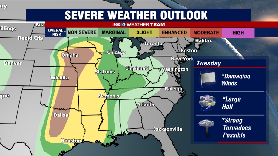
The same cannot be said for other parts of the country. The storm system that will be aiding in our warmth this week will power an intense severe weather outbreak across the Plains and parts of the Midwest on Tuesday and Wednesday. Cool, dry air mixing with warm, moist Gulf of Mexico air along with an intensifying jetstream is all a recipe for yet another week of severe weather and tornadoes across this region. The fourth week in a row.
While alarming, the repeated risks of severe weather were also expected this spring, as we are currently in what is known as a La Niña spring. These typically are very active when it comes to severe weather, and our region could have increased severe weather risks in May and June because of it as well.
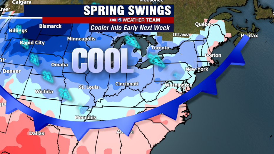
Thankfully, the storm system will weaken as it pushes eastward into the end of the workweek. The bad news is that after that cold front passes, our temperatures will start to be on a downward swing through the weekend. Lower 70s are expected to begin the weekend, but by the Easter holiday on Sunday, parts of our region may once again struggle to break the 60° mark. If this is not bad enough, the frontal boundary will stall just to our southeast.
A couple of disturbances will ride along this boundary, and the threat will be there for some showers on Saturday afternoon with the threat for a more substantial rain event by next Monday. At this time, Easter Sunday itself does look dry, but I cannot rule out the risk of introducing a few showers to this forecast as the week goes on.

I have been getting a lot of questions on when I expect that this pattern will let up, and if I foresee any period of sustained, consistent warmth. The short answer is that I do not really expect this spring will be one where we "settle in" to a consistent pattern. I think we continue to spring back-and-forth between periods of well above normal, and periods of cooler than normal, with stormy periods in between.
This is typically what we see in these types of La Niña springs. What I will say is that, as time goes on, the cooler shots should become progressively less intense in just how chilly they are. Seasonal normals are on the rise, as our daylight continues to lengthen and the sun angle continues to rise in the sky. Average high temperatures in D.C. hit 75° in less than one month, and at that point even a 10° below normal day still gets you into the middle 60s. So expect the "cold shots" to become less intense, but expect the pattern to continue to "swing" for the foreseeable future.