

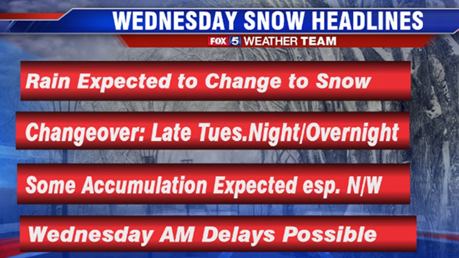
Snow to impact Wednesday morning commute; school delays possible

Snow to slow Wednesday morning commute; school delays possible
A mild Tuesday -- but all eyes are on Wednesday morning when snow is likely to hit the D.C. region. FOX 5's Mike Thomas has the latest.
WASHINGTON - Tuesday morning began with a mild start with temperatures across the region rising into the 50s in many locations. You would never guess that less than 24 hours from now, some of us could be seeing our first accumulating snow of the year.
It all starts with a cold front passing through the region this evening that will start dropping out temperatures through the second half of the day today. A weak wave of atmospheric energy will then ride this frontal boundary from southwest to northeast, enhancing precipitation as it does so.
Download the FOX 5 Weather App
The key to this entire forecast and the biggest difference in our various weather models is in the strength of this wave as it passes to the southeast of the D.C. region. If it is a stronger wave, then snowfall rates could be briefly heavy across parts of our area, enough that it could coat the grass and maybe some untreated and lesser-traveled roadways as it falls. Due to Tuesday's mild temperatures and ground temperatures being above freezing, once the snow does stop, any snow that did manage to stick should melt off rather quickly. This is not a long duration event. In fact, before Wednesday morning is done, we expect to see some sunshine returning to our region.
Here is a quick view of some of the overnight modeling: The European model, widely considered to be the most accurate by forecasters, has showers continuing into the early overnight hours before transitioning to a mix and then eventually snow before the 4 a.m. hour. It has a stripe of moderate snow across the Blue Ridge, western Fauquier, Loudoun counties in Virginia into Montgomery, Frederick, and Carroll counties in Maryland. These are the areas that the model gives the best shot at seeing over 1 inch of snow.
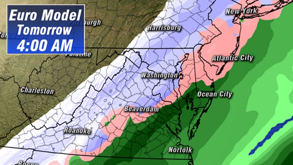
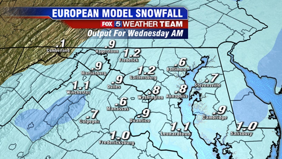
One interesting thing to note is the model did come a little cooler for some of our southeastern zones, showing about an inch of snow in locations like Fredericksburg, Virginia and parts of Southern Maryland. It is important to note though that they do struggle to get temperatures below freezing in these locations, so snow will likely have a harder time sticking around here. The European has been rather consistent over the past 24 hours with not showing any "big" totals.
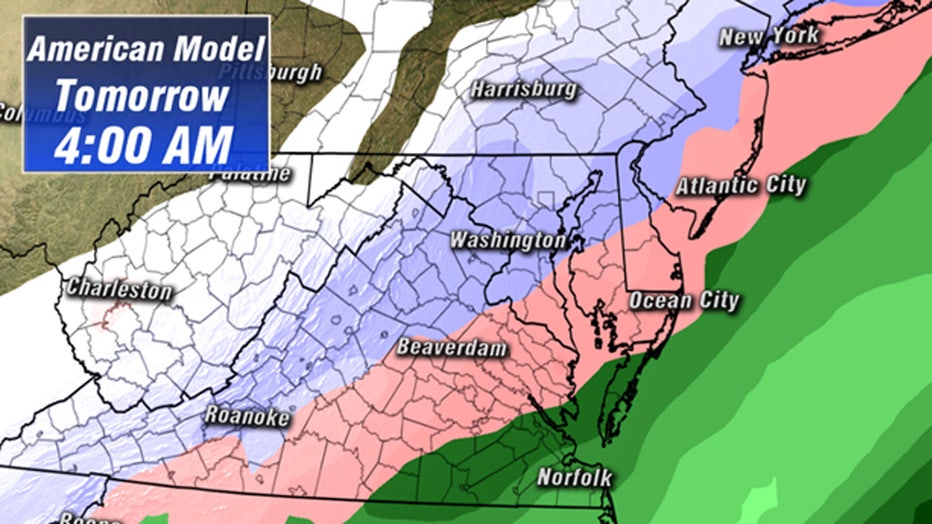
The American model remains the most moisture-laden of all the weather modeling, showing a more widespread band of snow setting up during the overnight hours along the Interstate-95 corridor stretching back towards the Interstate-81. If this model is correct, we could have a more impactful morning commute because snow rates would be heavier closer to the beltway which would result in more traffic issues, particularly in the pre-dawn hours.
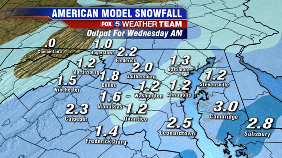
Even though it remains the most aggressive, the American model guidance has slowly been trending lower and lower with its forecast snow totals over the past 24 hours. This time yesterday it was showing the threat for widespread 2-to-4-inch amounts but has now fallen back to more widespread 1-to-2-inch amounts. This would still be what we could consider a "boom" scenario for our region since it has the most widespread coverage of these snowfall amounts.
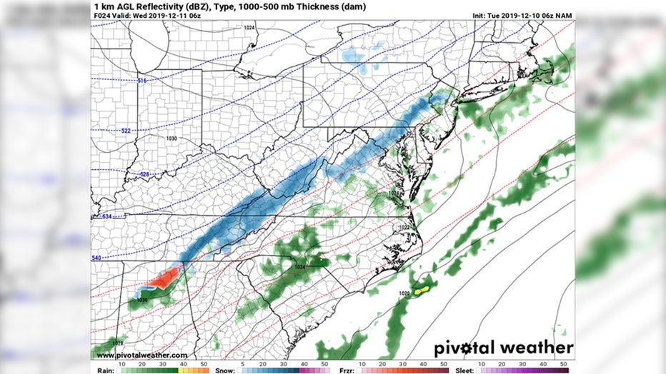
Now that we have covered what a "boom" scenario would look like, what would a bust scenario look like, which is a legitimate concern as well? The North American model is shown above. You may notice when compared to the others, it is a little moisture starved. It still shows some snow, but it's lighter than and not nearly as widespread as the other models above. This particular model is saying that the storm system that will pass to the southeast is going to have trouble overcoming the drier air moving into the area at the same time, thus leading to more "holes" in the precipitation shield, causing accumulations to be more light and patchy.
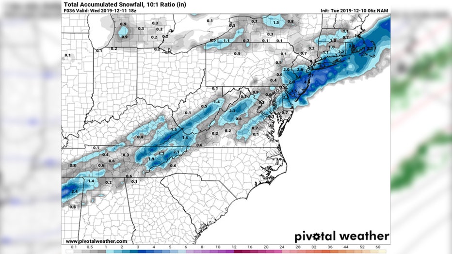
You can see the patchy nature of the snowfall here on the projected snowfall map. It still gives the upper Blue Ridge the "jackpot" 2-to-3-inch accumulations but leaves most of the lowlands with less than 1 inch of snow around the immediate D.C. area. The model also shows very light snowfall rates across our region, and with ground temperatures above freezing, if this ended up being the case, there would be a lot of melting on contact.
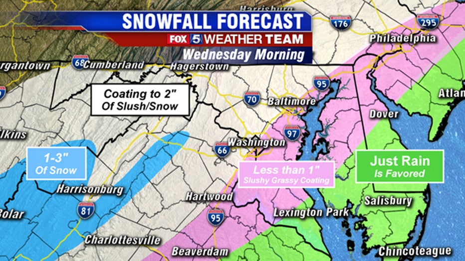
The local National Weather Service office is forecasting a very similar situation to the early morning weather guidance. They are expecting the highest amounts over the Blue Ridge, with some accumulations for the lowlands along the Interstate-81 corridor and west of the Interstate-95. For those along the Interstate-95 and east, they are also forecasting less than 1 inch of snow.
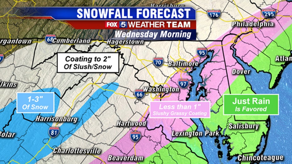
Our forecast this morning is a general blend of both the American and European guidances. Weather models often are too aggressive with how fast the coldest area gets into some of our eastern zones. Expecting this to be the case, we favor less than an inch of snow for those along and east of Interstate 95. The vast majority of our weather guidance says the best shot at accumulating snows will be just northwest of the Interstate-95 corridor. We believe the majority here are looking at a coating to 1 inch of snow, with spotty locations seeing a bit more. I do want to mention that with this particular system there is going to be such a thing as being too far northwest since it is a relatively weaker storm system. Dry air will likely rule the day across the Maryland and West Virginia panhandles, and I suspect that the valley towns here will likely make out with very little snow. It is the highlands and the mountains to the southwest of town, particularly the top of the Blue Ridge that should see the most snow with this particular event.
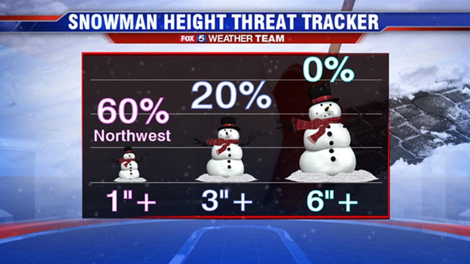
As for probabilities, for the counties immediately surrounding the D.C. metro area, as of this morning I do not have a whole lot of weather model support for getting 3 inches or more of snow on the ground, and nothing even close to half a foot of snow. So we will keep our probabilities highest in the 1 inch or less category, with some patchy areas making out with 1 to 2 inches. Again, an event like this is not going to be a "get out and play in it afterward" type of snow. The issues with this snow will mostly be associated with the fact it is just coming at the wrong time of day. The snow should wrap up even by the mid-morning hours, with some sun returning by the afternoon. Any snow that did stick early should melt quickly once it stops snowing with the surface above freezing and afternoon temperatures bubbling up into the upper 30s to lower 40s during the afternoon. We will have to watch for some patchy slick spots Thursday morning as everyone wakes up to subfreezing temperatures. However, these should be more patchy as winds blowing on Wednesday afternoon should do a good deal of drying as the melting occurs.
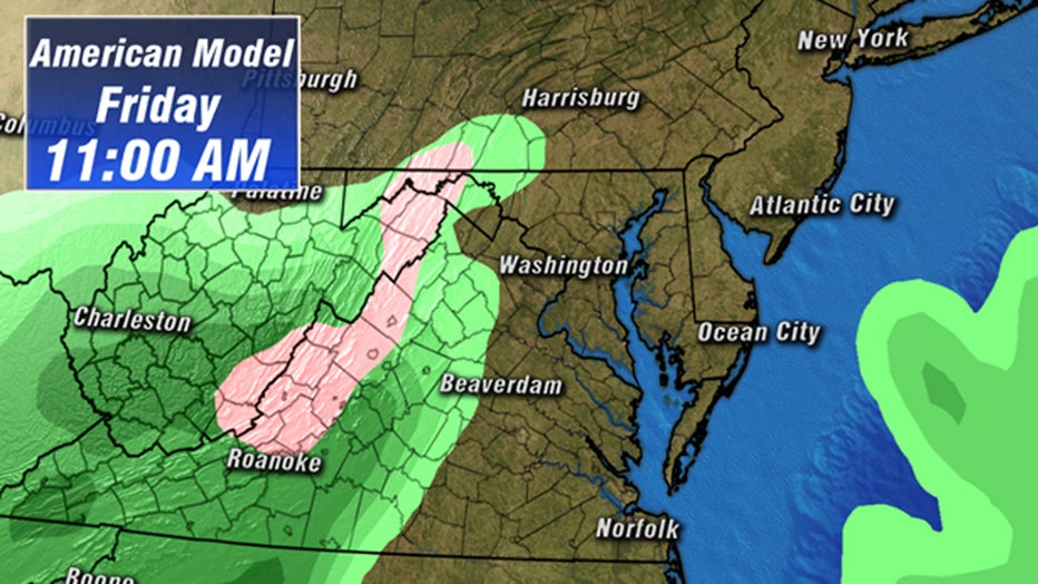
Looking ahead, Thursday is dry and cold as many will struggle to get temperatures out of the 30s. The cold air will start to exit our region on Friday. Whenever cold air of this magnitude starts to lift out of our region, warm air likes to "attack it" from the south, sometimes coming with a bit of moisture. At this time, the vast majority of weather model guidance suggests that the cold air will exit our region before moisture is able to reach us on Friday afternoon. However, a couple of models are trying to sneak some moisture in here during the morning hours of Friday morning when the cold air is still in place. If this happens to occur, parts of our region may have to keep their eye out for a little freezing rain. We have low confidence on this event at this time, but just want to give folks the heads up that it is something we are keeping an eye on for you. Stay up to date with the FOX 5 Weather Team on-air, and online. We will keep you ahead of this and anything else that winter may throw our way throughout the winter ahead.
Stay with FOX 5 on the app and online for weather updates:
Get the latest FOX 5 forecast here.
Check the latest Closings and Delays
Download the FOX 5 DC News App for Local Breaking News and Weather
Download the FOX 5 Weather App
Check the latest weather radars
Check for power outages in DC region
Stay up to date with the FOX 5 Weather Team on Twitter: