

Early snowfall expected Saturday before shift to rain across DC region

DC snow forecast: First significant snowfall of season expected Saturday
A slushy mix of snow could be on the ground by Saturday afternoon as the Washington, D.C. area prepares for its first significant snowfall of the season.
BETHESDA, Md. (FOX 5 DC) - The FOX 5 Weather Team has been closely monitoring a winter storm that is expected to impact the Northeast and Mid-Atlantic on Saturday and Sunday.
With new data and projections coming in, what are our latest expectations? Let's dive in!
As for timing, the latest projections are now leaning towards a faster overall storm. This means one that begins earlier on Saturday, as early as the middle morning hours, but one that wraps up faster as well.
Most projections show the storm leaving our region before the midnight hour on Saturday night.
This would leave Sunday as a cold and windy, but dry, day for any clean-up or digging out that parts of our region will have to do in its wake.
With the timing of the storm itself coming better into focus, the issue then becomes hammering out the details of what that means for the storm.
Typically, the coldest part of the day is just before dawn, while the warmest is in the middle of the afternoon. This means that the earlier the storm arrives, the more likely it is to start as wintry precipitation. We believe this will be the case with this storm.
D.C., Baltimore, and even parts of southern Maryland may see this system begin as snow or sleet as early as 9-10 a.m. on Saturday.
Most guidance shows a healthy pool of cold air in place during the morning hours. The key to snowfall totals is how fast this cold area will erode and retreat northward.
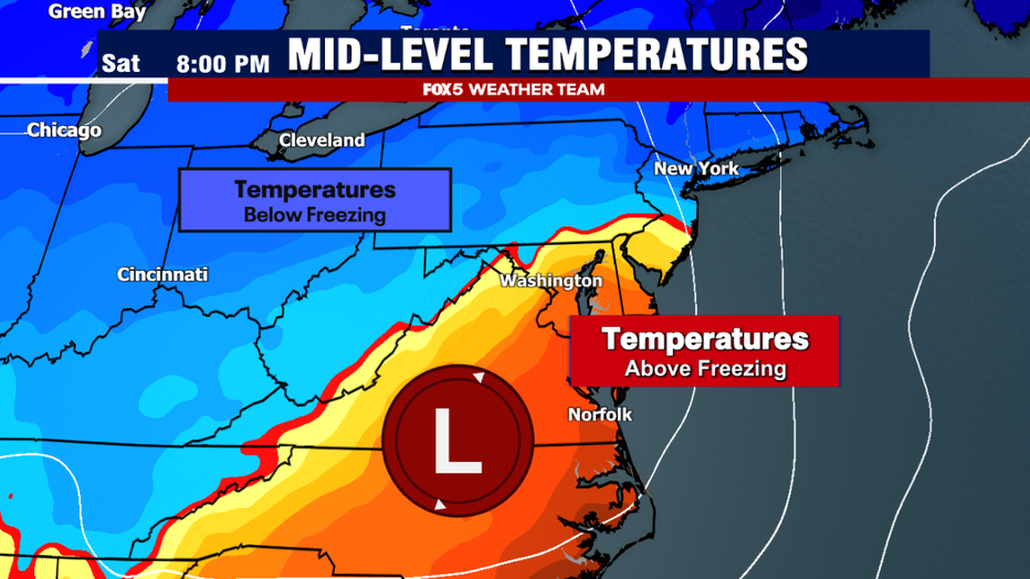
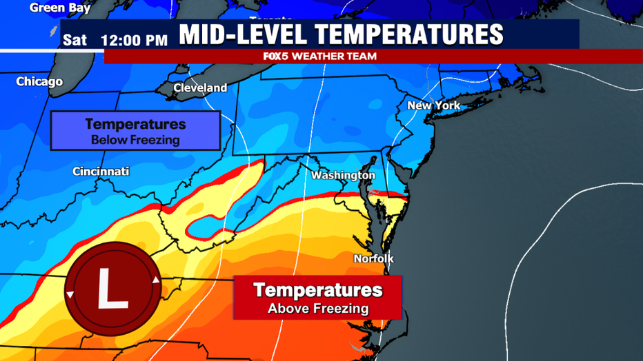
By the middle of the afternoon and progressing through the evening hours, as the storm system starts to intensify to our south, winds will pick up out of the south and east.
This is important because those winds will carry some southern and Atlantic "warmth" into the region. That typically happens above the surface first, causing snow to turn over to mix and sleet pellets, before changing over to all rain as the warm layer expands.
The question for us forecasters is how far north and west this rain/snow line will progress, and more recent trends have continued to push that line farther and farther west.
While western areas will still see higher snowfall totals because they are expected to stay snowing longer, a change over to mix at any point will reduce totals compared to pure snow.
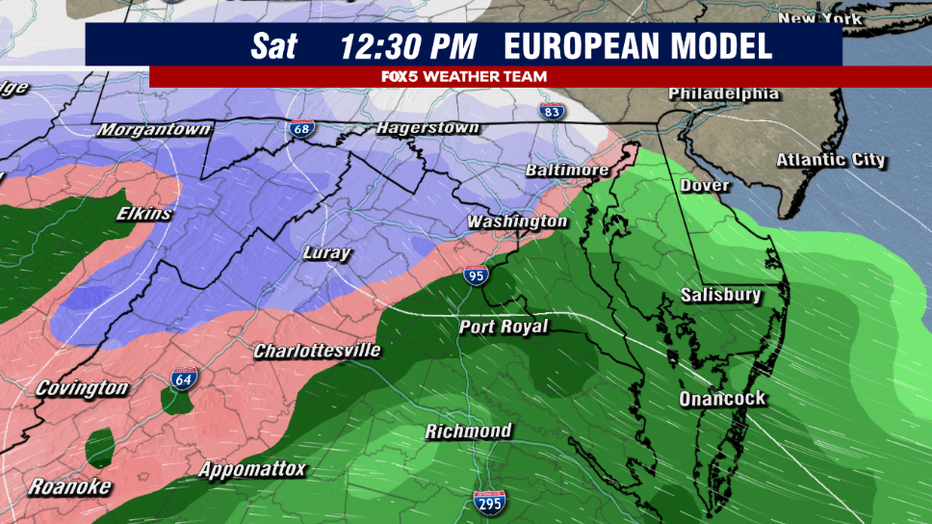
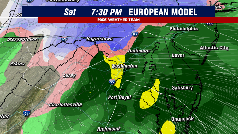
At this time, FOX 5 has not seen any weather models that show all the snow for D.C. and Baltimore. Expectations are that after a wintry start, it will change over to rain pretty quickly in the afternoon.
This change is not expected to come until the late afternoon and evening for those areas to the far northwest.

DC snow forecast: Most significant snowfall in 2 years possible Saturday for parts of DC metro area
A slushy mix of snow could be on the ground by Saturday afternoon as the Washington, D.C. area prepares for its first significant snowfall of the season - and possibly the most snow parts of the metro area have seen over the last two years.
So what are our latest expectations?
While we do believe D.C. starts as snow and mix, and potentially could even see a little slushy accumulation during the morning and lunchtime hours mostly, we do favor a change over to an at times heavy, cold rain that will likely naturally wash away any accumulation received for the most part.
Mother Nature will likely do her plowing on this one in the immediate D.C. and Baltimore areas.
Once you get west of the I-95 corridor, we are expecting about 2-4" of wet snow out closer to the highlands, with, of course, the most expected in the mountains west of the I-81 corridor.
For those areas out to the west. As you get up towards the elevation climb in northern Montgomery, Frederick, Carroll, and Fauquier counties — the question is not so much about whether you will see snow longer – but instead about how heavy that snow could be.
Light snow is picky. Ground temperatures have to be below freezing for it to stick, otherwise it simply melts on contact.
Heavier snow is much more tricky. Snow can pile up on just about any surface as long as the rate at which it is falling is faster than the rate at which the ground can melt it.
Whether or not a band of heavy, thumping snow will be present with this storm is something that weather computers have been struggling with over the last couple of days.
When news breaks, stream FOX 5 DC anytime. Get the FOX Local app on your smart TV.
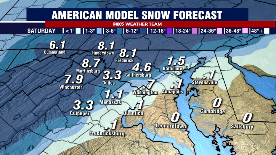
The American model, seen above, has been the most aggressive with the snow coming down heavily for several hours early Saturday afternoon just north and west of D.C. before the eventual changeover to mix and rain.
What we would call a "boom" scenario shows 4-8" as close as western Loudoun, Northern Fauquier and Montgomery counties, and Frederick and Carroll counties.
This will be a threat to monitor going forward.
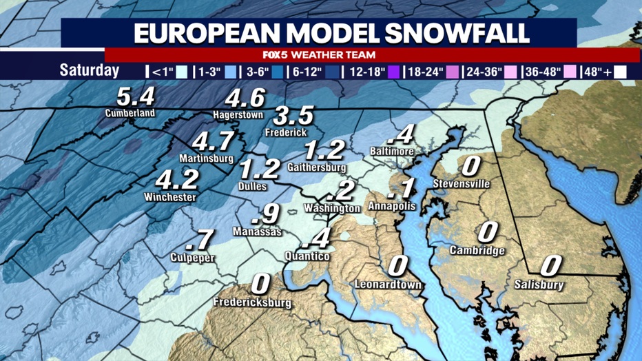
On the other hand, the oftentimes more reliable European weather model shown above is considerably less impressive with snowfall rates. This leads to a little more ground melt occurring and keeps snowfall totals more suppressed before a faster changeover to mixing compared to its American counterpart.
The rate of initial snowfall and the speed of the changeover are the two keys that will lead to this storm being a boom or a bust in those western zones.
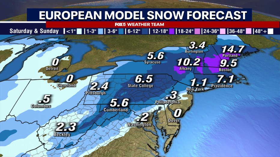
As for the rest of the Northeast, most models show that D.C. will not be the only major city to suffer the wrath of the dreaded rain/snow line. Other I-95 cities like Philadelphia, and New York City may miss out on some of the larger totals as eastern winds and mild air of the Atlantic lead to mixing. Cold air is expected to fight harder in the interior Northeast, however. Boston will likely get one of the better snowstorms of the past few winters out of this winter storm, while some interior parts of New England could see around a foot of snow.
Even around the Mid-Atlantic, local ski resorts in our mountains could do quite well with the coming storm.
Once we get beyond the weekend, is there anything else that we have our eyes on?
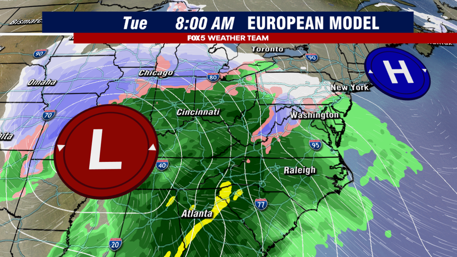
Well, the first major blizzard of 2024 could arrive early next week — just not in the D.C. region. The stronger storms usually have a better model agreement about a week in advance, and both the American and European models are in strong agreement of a major storm in the Midwest early next week, centered around next Tuesday.
It could be the first storm that gets widespread blizzard warnings, particularly in the Upper Midwest, so travelers next week be warned!
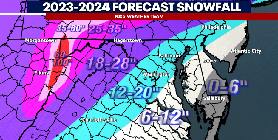
DMV Winter 2023-2024 Outlook: Why we're expecting more snow, chance for blizzards in DC this winter
With a potentially strong El Niño in play for the 2023-2024 winter season, we're forecasting more snow than an average winter for the Washington D.C. metro, Northern Virginia and Maryland.
For the D.C. region, the center of this storm is expected to pass far to our west. Without a major block in place to force the storm onto the coastline, we are not talking about a blizzard threat here in the Mid-Atlantic region.
The storm could drag up so much warmth on its eastern flank that temperatures on Tuesday could approach 60°F on Tuesday afternoon and evening. However, the morning hours will need to be monitored. Cold air in place with a retreating high pressure to the north could lead to something known as "cold air damming," which is where a northeast wind traps low-level cold air up against the Appalachian Mountains.
This could lead to some quick morning snow or ice that could make roadways slick for the morning commute, potentially impacting local schools.
It is something we will have our eyes on closely over the next week.
FOX 5 will continue to keep you up to date on these storms, and any more that happen to come our way this winter season.