

Dreaming of a White Christmas? A potential DC winter storm threat could make it happen.

Dreaming of a white Christmas? Eyeing potential winter storm threat next week
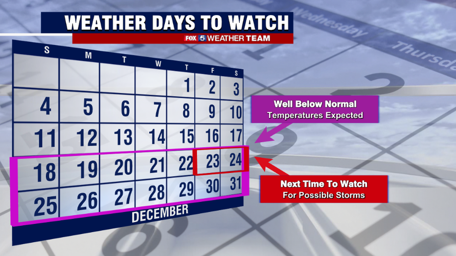
The FOX 5 Weather Team is monitoring a potential winter storm threat that could impact the D.C region the weekend of Christmas. Here’s what we know.
With the first winter weather advisories of the season in place on Thursday, social media was abuzz with talk of a big winter storm that could bring snow to DC, Maryland and Virginia heading into the Christmas weekend.
No, not the storm that caused the advisories, which brought some ice to parts of our region on Thursday morning, but instead the buzz was about a potentially bigger storm that could potentially happen just before Christmas.
The buzz is not without merit, we are in fact watching a storm system around that time, but that does not necessarily guarantee that it will be snow for our region. Let's jump in to what we know.
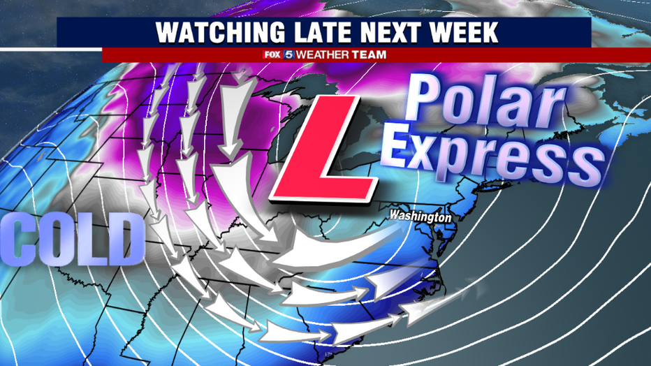
Despite being more than a week away, there is one aspect of the forecast that we are pretty confident in. The cold. Upper atmospheric features are lining up in such a way that there will be a strong discharge of arctic air from the polar region into the contiguous United States during the latter half of next week.
The most extreme of these temperatures will be across the Northern Plains, where some spots may not make it out of the negative teens for daytime highs by the end of the week.
What we are dubbing the Polar Express could be the strongest cold air outbreak to hit the eastern United States in the month of December in a couple of decades, since possibly December 2000.
There is even the risk of subfreezing temperatures along the Gulf Coast and into central Florida, with a few models even hinting at the potential for "Gulf Effect Snow"…that is snow created by cold air traveling over the warm waters of the Gulf of Mexico, for some coastal cities. It is an extreme push of cold air.
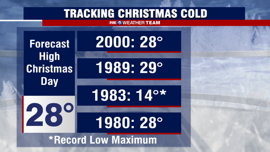
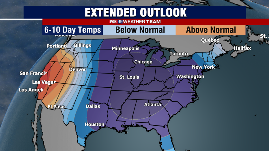
Regardless of whether our region does see snow late next week, the Christmas holiday next weekend is looking quite cold. Some models are suggesting that we may not break 30° on Christmas Day.
If this indeed ends up being the case, it would be a top 12 coldest Christmas in D.C. history, and certainly the coldest in recent memory. Since the turn of the century only once Christmas, December of 2000, failed to make it above freezing for the day. Keep the ugly Christmas sweaters extra handy this year.
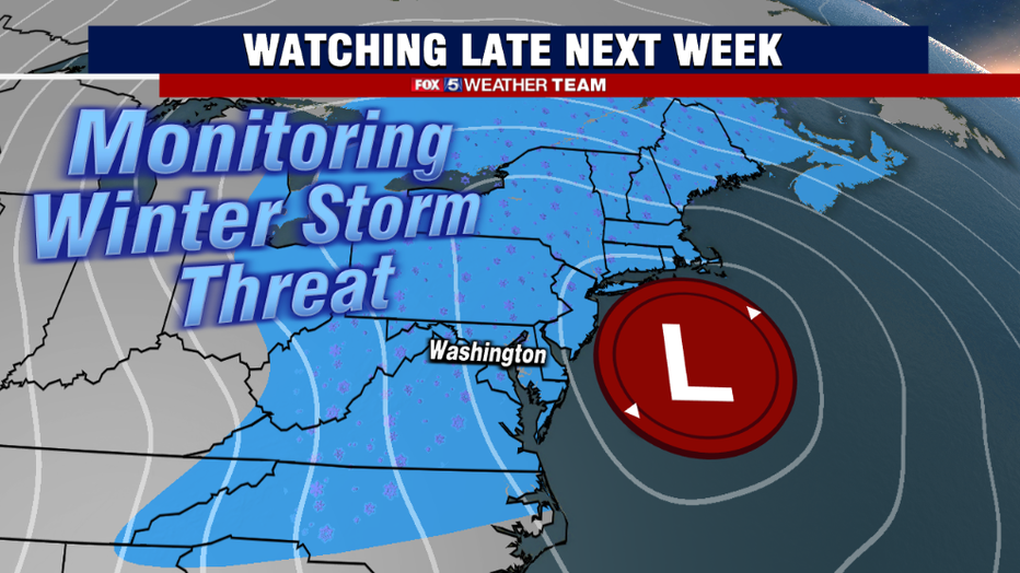
Now onto the less confident part of the forecast, the threat for a storm. What is true is that the upper atmospheric features present at this time suggest that the pattern is ripe for a bigger storm.
The issue become that, at this range, that is about all we can say with confidence. Even a week away, with the strength of the Arctic air and the speed with which it will be plunging into the middle of the country, I can say with relatively high confidence that there will be a storm. However, when it comes to where exactly that storm will be at the surface, that much is harder to pinpoint. Much like this week's storm, it could easily end up being more rain here, with the bigger snow falling elsewhere.
Those key details just are not known yet, no matter what you read on social media. Getting significant snow down into Washington, D.C. this early in the season is difficult, and requires several things to come together just right.
What is true is that there have been several runs of various weather models that have shown snowfall for our region sometime between next Thursday evening and Christmas Eve morning.
However, what is also true and extremely common when you are talking about a storm that is about a week in the future, is that the weather models have not all showed this scenario. Some have shown rain for D.C., some a mix, and some have just missed our area all together. The vast majority have shown a storm though, but the type of precipitation remains much harder to lock in this far in advance.
So what do we want you to know? We simply want to inform you that yes, there is a potential storm that we are keeping an eye on early next week. We want you to continue to check in with us, on air, online, and on social media where we will continue to have daily updates on what this storm could mean for our region.
Late next week is one of the busiest travel times of the year, and we know that many will be heading into and out of the region to see loved ones for the holidays. This early in the forecast period though, we do not recommend changing any travel plans for this storm just yet. We do not believe we will be able to say with relative certainty what type of impacts our region will see until Monday or Tuesday of next week. So please stay tuned.
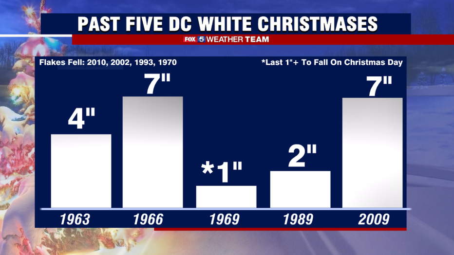
If we did happen to get snow prior to Christmas, it would make for some rather rare company for the city of Washington. Since recordkeeping began, less than 10% of all Christmas Days have had measurable snow on the ground. You have to go back thirteen years, to Christmas of 2009, for the last time D.C. had measurable snow for the holiday.
You have to go back to the 1960s for the last time you had measurable snow on the ground in multiple years in the same decade. Christmas snow is a rare occurrence indeed. While chances of a white Christmas are indeed higher than normal this year, just given the cold pattern itself, this is still no guarantee that it will in fact, snow. Just a statistical fact.
We will continue to monitor the pattern and give you updates in the days ahead.