

April showers: Several rain chances this week as active spring pattern continues
The old adage goes "April showers bring May flowers" and if this week is any indication of what the month could bring, the D.C. area could look like a greenhouse by next month.
After a weekend that featured a decent amount of sunshine, the first full week of April is going to feature more clouds, several rainfall chances, and more gusty winds on occasion as well.

While we made it through our Monday mostly dry, a warm front will struggle to make its way northward through our region tomorrow morning.
Showers could scatter out along this boundary as early as the morning commute hours, but will become more likely later in the day as a wave of low-pressure forms and rides the boundary from west to east.
Download the FOX 5 DC News App for Local Breaking News and Weather
As this system approaches the coastline, it will tap into some Atlantic moisture and we could have a period of steady to heavy rain over the region after sunset on Tuesday until about sunrise on Wednesday.
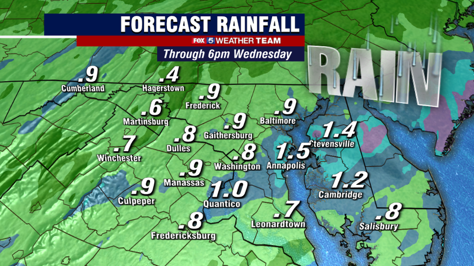
Some areas could pick up over an inch of rain as this batch pushes through our region. While the pattern has more recently been wet, we actually have been running abnormally dry for the year so far.
Rainfall for the month of March came in about an inch below the seasonal average. So, a widespread soaking rain could bring our region back to about normal for the season. Not a bad way to kick off the growing season around our region. We will have to monitor for any potential flooding risk with the rain given the wet pattern in the last week, but any such risks should be isolated.
Wednesday afternoon should progressively become drier, and we could even see some peeks of sunshine before the day is done – though a stalled frontal boundary nearby means the threat of pop-up showers will remain in the forecast.
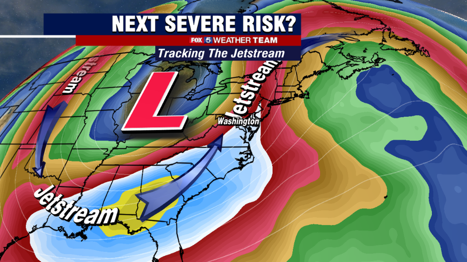
Our attention will then turn toward Thursday when a strong dip in the upper jetstream will push across the eastern half of the country. This is expected to be another big severe weather maker in the South, where many areas will see their third week in a row of tornado risks.
The energy with this next storm system is expected to push into our region during the day on Thursday. While similar in nature, it is also a very different setup from the one our region experienced just last week, when a pair of EF-0 tornadoes were confirmed in Fairfax County.
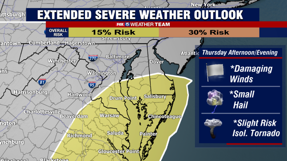
The worst of the energy in the atmosphere needed for severe weather looks like it will stay primarily to our south and east. Still, parts of our region including the Eastern Shore, Northern Neck, and Southern Maryland were close enough to be included in the outlook for the potential for damaging winds and perhaps even an isolated tornado.
We will be closely monitoring the guidance in the days ahead.
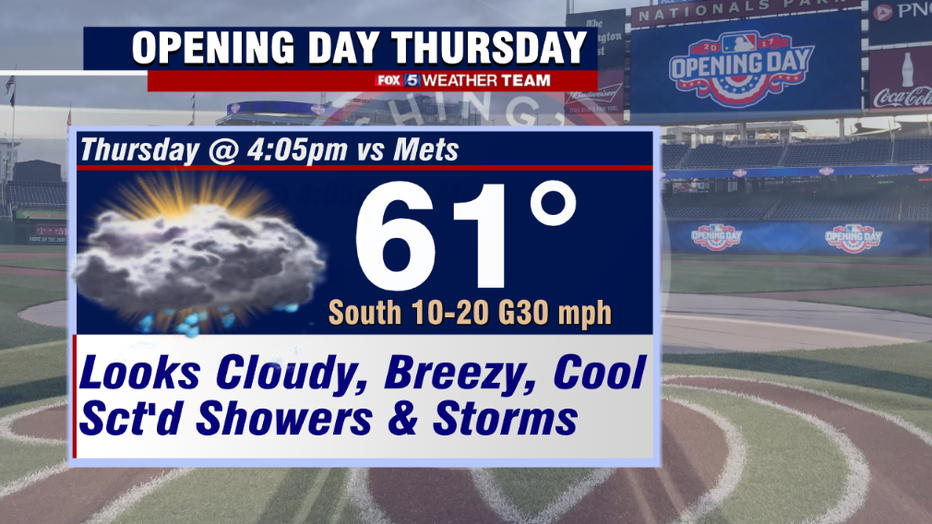
This, of course, makes the planning difficult for the opening day for the Nationals. The Mets come to town to kick off the 2022-2023 Major League Baseball season at 4:30 p.m. on Thursday afternoon. Unfortunately, it does look like they will dodge some showers and perhaps even a storm or two as they do so.
It is also not going to be the warmest of spring days either. Those planning on heading down to the ballpark should plan on bringing the cool gear in addition to the rain gear, as we should stay in the 50s much of the day.
As if that was not bad enough already, the weekend ahead looks like it is going to bring yet another surge of cooler air.
Average high temperatures by Saturday are in the middle 60s, 66° in fact, here in Washington, D.C. However, current guidance suggests that we will likely spend much of it about 10-15° cooler than normal in the middle 50s.
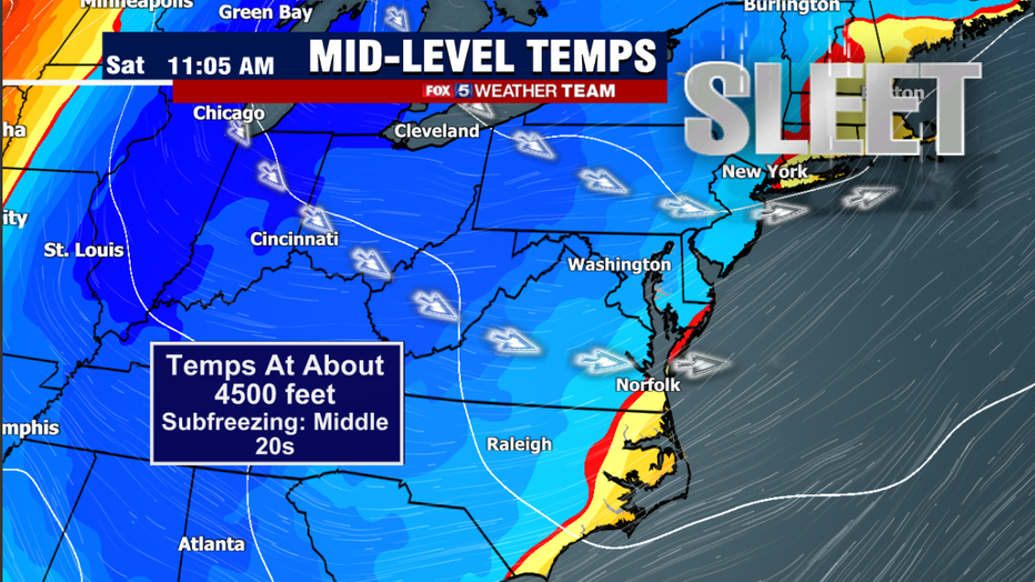
Strong northwest winds off the Great Lakes could lead to some passing showers on and off during Saturday afternoon as well. With temperatures just a few thousand feet up falling through the 20s, some of these showers could even have a few ice pellets, what we call graupel, mixed in as well.
Sunday should be drier, but still breezy with scattered clouds.
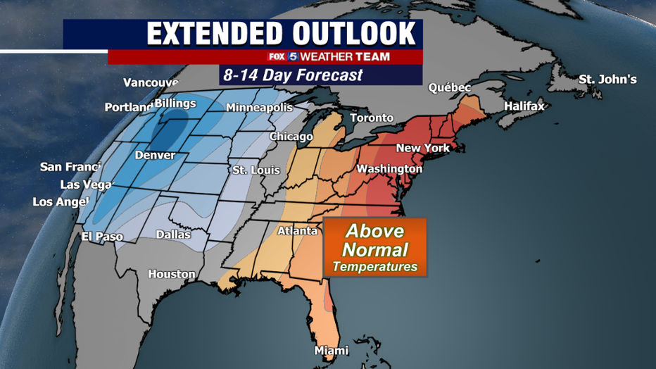
If there is any bright spot, temps do look like they are going to spike beyond the weekend. Current long-range guidance suggests we are in for a period of much warmer weather by the middle part of next week. So hang in there!
April is known for its temperature swings and this month is expected to continue to be a very active one when it comes to severe weather and storms. This goes hand in hand with these temperatures swings, but as the sun angle continues to increase, we can only keep the cooler air around for so long.
Summer is only 78 days away!