

DC Weather: Temperatures climb to 90s as spring heat wave arrives this weekend
Spring heat wave to bring 90-degree weather to D.C. region
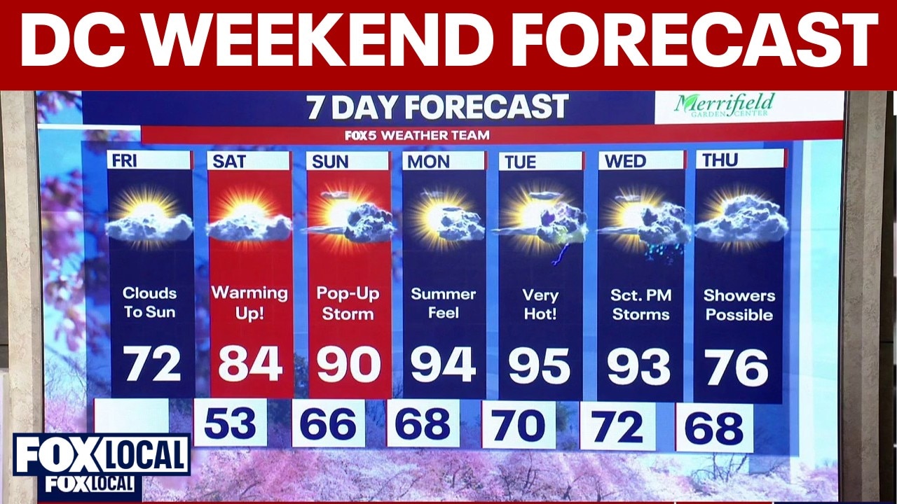
After a seasonably cool start Friday morning, a ridge of high pressure will settle over the Mid-Atlantic, driving temperatures well above normal for mid-May.
WASHINGTON - Summer-like heat is returning to the Washington D.C. region as temperatures climb into the 90s by early next week.
What we know:
The National Weather Service confirms that a significant warming trend is underway across the region. After a seasonably cool start Friday morning, a ridge of high pressure will settle over the Mid-Atlantic, driving temperatures well above normal for mid-May.
FOX 5 meteorologists are keeping a close eye on the "summer-like" pattern developing.
"Here comes the heat for real," says Chief Meteorologist Tucker Barnes. While today will remain comfortable in the low 70s, the "heat wave" begins in earnest as we head into the weekend and next week.
Experts note that while the air will stay mostly dry through Saturday, we will start to see the humidity "creep back in" by Sunday. This will set the stage for heat index values that could make it feel much hotter than the actual thermometer reading.

Temperatures are climbing fast across the DC region this weekend into Monday. After a cooler Friday near 72°, highs surge into the mid-80s Saturday, around 90° Sunday, and the mid-90s by Monday.
Sunshine through the weekend
Timeline:
- Washington D.C. & Suburbs: Full sunshine today with highs in the 70s. Saturday brings the mid-80s, followed by the first 90-degree readings by Monday.
- Mountains (I-81 Corridor): Mostly clear and dry, though a stray "pop-up" storm is possible Sunday afternoon as the heat builds.
- Next Week: The peak of the heat arrives Monday and Tuesday, with triple-digit heat indices possible in some spots.
Why you should care:
Since this is our first real bout of high heat this year, your body may not be acclimated to the 90-degree weather yet. It’s a good time to check on your AC units and make sure your patio furniture is ready for the sun.
With the heat index potentially approaching 100 degrees by Monday, remember to keep your pets hydrated and limit strenuous outdoor activity during the "heat of the afternoon."
What's next:
The intense heat looks to hold steady through the first half of next week. We will be watching for any "pop-up" storms that might provide brief relief, but a more significant cooling trend isn't expected until a cold front arrives late Wednesday into Thursday.
The Source: This story includes information from the FOX 5 Weather Team and the National Weather Service.