

Tropical Storm Nicole remnants to bring waves of rain, wind to DC region

Nicole's remnants Friday
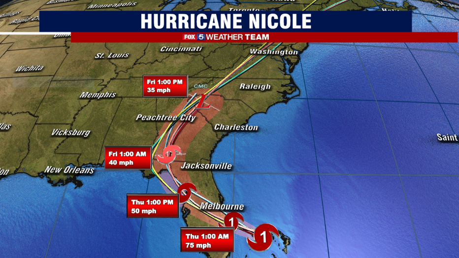
Tropical Storm Nicole made landfall in Florida Thursday, according to the National Hurricane Center. The storm is "expected to dissipate as it merges with a frontal boundary over the Mid-Atlantic United States by Friday night," the center said. FOX 5's meteorologist Mike Thomas says the D.C. region can expect to see Nicole's remnants Friday in the form of rainfall.
BETHESDA, Md. (FOX 5 DC) - Nicole reached hurricane strength Wednesday evening while making landfall on Grand Bahama Island, with eyes set on eastern Florida for the early morning hours of Thursday.
Nicole became a hurricane in a special update at 6 p.m. EST on Wednesday evening as sustained winds were reported to have reached 75 mph. Hurricane warnings extend up the Florida coastline from Boca Raton northward to Daytona Beach in a state that continues to recover from a hit from major Hurricane Ian in late September.
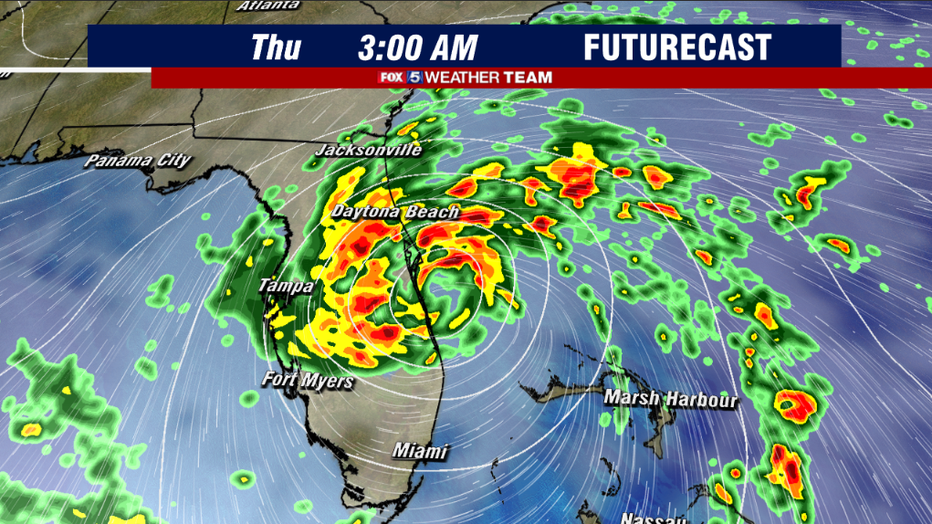
While Nicole is not expected to be nearly as destructive as Ian, the National Hurricane Center still projects that she will remain a hurricane prior to making landfall early Thursday morning.
Much of the central and northern Florida Peninsula is expecting potentially flooding rains and winds of at least tropical storm force winds, which is expected to lead to numerous power outages in the region. Those who happen to be traveling southward on Thursday or Friday, or have flights through Altanta, Orlando, or Miami, should monitor for travel impacts and flight delays due to the storm.
Nicole is a very late-season storm to be impacting the United States.
November storms can and do happen, but they tend to be much weaker as storms in August through October as water temperatures begin to cool and jet streams become more active ahead of the winter. Hurricane Nicole is the latest hurricane on record to ever hit the east coast of Florida, the latest since Nov. 4, way back in 1935.
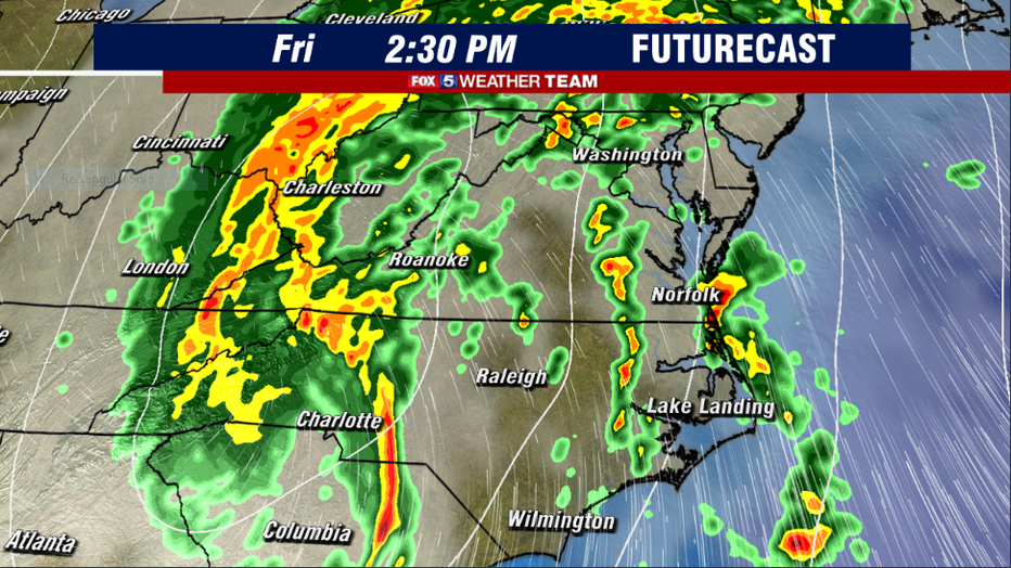
It will also be the first November hurricane to hit the state since Hurricane Kate hit the Panhandle of Florida as a category 2 back in 1985 on Nov. 22. After impacting Florida, Nicole is expected to get picked up by a cold front and subsequent jet stream pushing into the eastern half of the country ahead of the weekend. This will cause the system to rapidly lose tropical characteristics, but moisture from the storm will also be stretched northward and carried into the Mid-Atlantic and Northeast by Friday.
Friday is of course Veterans Day, a federal holiday, so many will be off of work and school.
For those who do plan to venture out, the first impacts from Nicole could hit the D.C. region in the pre-dawn hours as the first of the rains start to come across. As the storm center is expected to eventually pass to the west of the D.C. metro area, we will not be in a sector that sees steady rain all day. Instead, the rain will come in waves with periods of dry weather in between. That does not mean it will be a nice day, however, as winds are expected to be gusty all day long, with peak gusts between 30-50 mph for the D.C. region.
The one benefit that the storm will bring is that the strong wind out of the south will bring up a lot of warmth, with highs potentially in the lower 70s. It will feel quite tropical though with high humidity coming along with it.
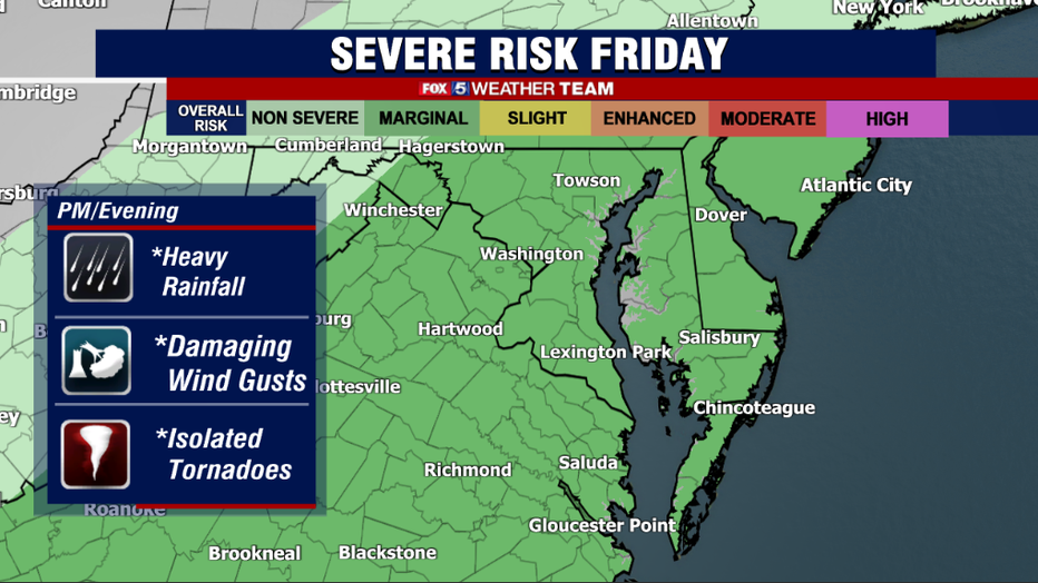
Into the afternoon and evening hours, on-and-off waves of showers and even some thunderstorms are expected to continue in our region. With the storm system adding some enhanced low-level "spin" to the atmosphere, we have to keep our eye on the risk that a few of these thunderstorms could be strong to severe.
Isolated damaging wind gusts within this storm is the primary concern, but with that additional spin we cannot rule out a tornado risk. It is something quite common with tropical systems like this when they pass to our west. While we are not anticipating any sort of tornado outbreak like Hurricane Ivan caused, for example back in September 2004, we simply have to keep our guard up for the threat of a few tornadoes given the situation.
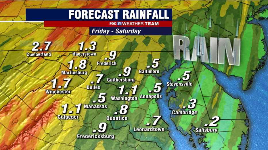
Another common feature with tropical systems is the threat of flooding rains. As we have not been particularly wet in the city in recent weeks, flooding risks should remain minimal. Although an isolated flash flood warning in a heavier thunderstorm embedded in one of Nicole's bands cannot be ruled out. Flooding risks would be the highest along the west of the I-81 corridor, including much of western Virginia and West Virginia, as well as the Maryland Panhandle.
This is where rainfall could be more consistent throughout the day, with fewer breaks in the action. Rain (1-3 inches) is possible in these regions, which means flooding risks would be higher.
The good news is that Nicole will exit our region in time for the weekend. Any lingering showers should exit the region prior to sunrise on Saturday morning.
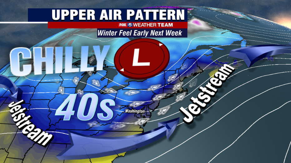
The bad news is that just because the rains exit, does not mean that the impacts from Nicole do not linger through the weekend. Nicole will work in tandem with a dip in the jet stream and a strong upper-level low moving through the Great Lakes to drop our temperatures significantly throughout the day on Saturday — with the cold continuing through early next week.
Many will see high temperatures in the 40s during the front half of next week; highs more typical of the middle of December. Overnight lows are expected to drop into the 20s and 30s, including the threat of the first freeze of the year inside the beltway early next workweek.
Get those winter coats ready!