

Tracking the super El Niño: What it means for fall and winter
Super El Niño on the way: What it means for DC weather
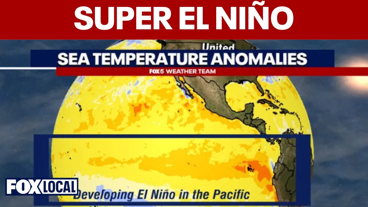
A potentially powerful, so-called "super" El Niño is rapidly developing in the Pacific Ocean as we continue our journey through the spring months. Most forecast models from major climate centers are increasingly suggesting that the event could rival or even exceed some of the strongest recorded El Niño episodes seen in 1982-83, 1997-98 and 2015-16.
WASHINGTON - Oceanographers and meteorologists are tracking significant water temperature anomalies in the equatorial Pacific Ocean, with the latest data suggesting conditions are already well into El Niño territory.
Water temperatures in the equatorial Pacific have been warming through late spring and summer and are expected to continue warming throughout the fall and winter seasons. According to the latest Oceanic Niño Index (ONI) data from the National Oceanic and Atmospheric Administration (NOAA), sea surface temperatures have reached moderate El Niño levels—fast approaching the peak temperatures observed during the strong 2023–2024 El Niño event.
Climate and ocean models continue to predict that a potentially powerful "super" El Niño will develop in the Pacific Ocean through the upcoming autumn. Most forecast models from major climate centers increasingly indicate that this event could rival or even surpass some of the strongest recorded El Niño episodes, including those of 1982–83, 1997–98 and 2015–16.
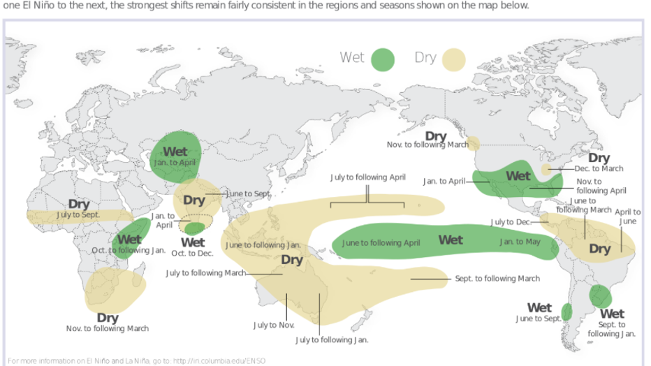
The effects of an El Niño event vary significantly around the world, as shown in the Columbia University/NOAA graphic.
Forecast models suggest it could even rival the Super El Niño of 1877, which computer simulations and reanalysis data indicate may have been one of the strongest in recent history. While data limitations from that era introduce some uncertainty, historical records confirm that the 1877 event coincided with severe global impacts. The Great Famine of 1876–78 in India, the Great Drought of 1877–79 in Brazil and the Great Drought of 1876–78 in China were all primarily attributed to this event, compounded by poor crop management and export policies. The combined global agricultural impacts resulted in an estimated 30 million to 60 million deaths.
Historical impacts in North America
Timeline:
The effects of a strong El Niño vary significantly around the globe. In North America, a very strong event produces distinct weather patterns, though local conditions can still vary from a typical year.
During the 1877 event, the western United States—particularly California—experienced several extreme rainfall events, while the southern states dealt with prolonged heavy rains. In the Washington, D.C. region, that El Niño coincided with The Great Flood of 1877. Following three to five days of nearly continuous, heavy rainfall, the Potomac, Antietam and Conococheague rivers rose to extreme levels.
The flooding caused major damage to infrastructure and bridges, particularly along the C&O Canal and surrounding areas near Martinsburg, West Virginia and Cumberland, Maryland.
The most pronounced regional impacts occurred during the winter months. The North American winter of 1877–78 was widely referred to as "The Year Without a Winter." It stood as the warmest winter in Minnesota history for over a century until it was surpassed by the winter of 2023–24.
In Washington, D.C., the average recorded temperature for that winter was 38.7°F. While that ranked in the warmest third of winters in the city's 154-year observational record, it sat near the bottom of that group.
Official snowfall measurements were not recorded that winter, but newspaper archives from the era indicate an absence of significant snowstorms, noting that the Mid-Atlantic experienced far more rain than snow.
Atlantic hurricane season: below-normal activity expected
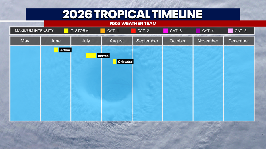
There have only been three named tropical storms, and no hurricanes named this hurricane season. (File Photo)
What's next:
Through August 13, the Atlantic season has seen three named tropical storms and no hurricanes.
One of El Niño’s clearest impacts is on the Atlantic hurricane season, with NOAA and major forecasting centers continuing to project below-normal overall activity.
Strong El Niño events typically increase upper-level winds across the tropical Atlantic—a phenomenon known as vertical wind shear. This hostile environment acts to disrupt developing tropical systems, generally reducing the overall number of hurricanes. Consequently, the Atlantic basin is expected to experience fewer named storms and reduced major hurricane activity compared to recent years.
However, a quieter season overall does not eliminate the risk to the East Coast:
- Storm tracks: Historically, even quiet El Niño years have produced severe Mid-Atlantic impacts when storm tracks curve northward along the eastern coastline. It only takes one landfalling storm to cause widespread disaster.
- Warm water anomalies: Above-average Atlantic Ocean surface temperatures may partially offset El Niño's suppressing effects this season—a factor forecasters are watching closely as the peak of hurricane season approaches in mid-September.
Continuing Mid-Atlantic drought improvement
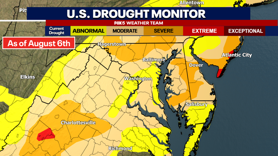
The Drought Monitor for our region as of early August 2026, showing most of our region in moderate drought. Drought conditions have improved since the start of July, however. (File Photo)
Drought conditions across the Mid-Atlantic continue to gradually improve thanks to frequent summer thunderstorm activity. Higher humidity levels—partially aided by the developing El Niño—have driven several rounds of heavy rain across the D.C. region over the past month.
Further drought relief is expected. El Niño-driven storm tracks typically become more active by late summer and into autumn. Historically, stronger El Niño patterns increase precipitation across much of the southern and eastern United States during the cooler half of the year.
Fall 2026: An active storm pattern ahead
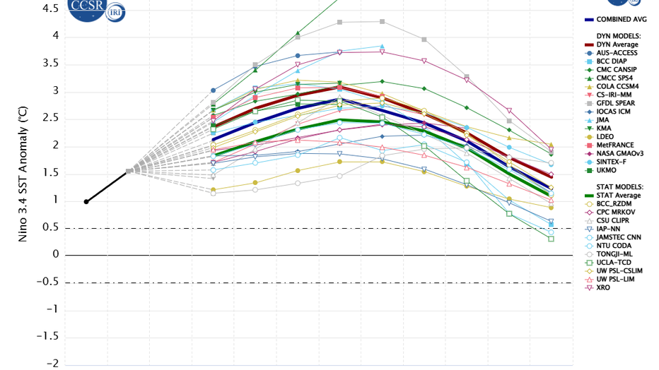
The most recent weather model predictions for El Niño continue to show it intensifying through the end of the fall, when it hits "strong" to "very strong" levels. (Source: Columbia University)
By autumn, El Niño’s influence on North American weather patterns typically intensifies. For the Mid-Atlantic, this often translates to:
- More frequent coastal storm systems
- Above-average overall precipitation
- Milder temperatures, particularly overnight lows
Fall could become noticeably wetter than normal across the Washington, D.C. area and the Interstate 95 corridor. Mild conditions may persist well into November, as arctic air masses historically struggle to establish themselves across the eastern U.S. during a strengthening El Niño. As a result, the onset of true winter cold is likely to be delayed compared to last year.
Winter 2026–27: What a "Super El Niño" Could Bring
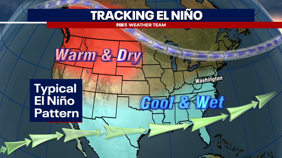
The winter pattern during an average El Niño event, although stronger El Niño cases are noted to bring much milder conditions to much of the country along with a much stronger tropical jet stream. (File Photo)
Historically, strong El Niño winters feature an active southern storm track, delivering wetter-than-average conditions across the Southeast and Mid-Atlantic alongside generally milder temperatures. While the jet stream pattern becomes more favorable for coastal storms and nor’easters, those systems do not always bring snow to the D.C. metro area.
Historical "super El Niño" events demonstrate that while these seasons consistently feature mild overall temperatures, their impact on Mid-Atlantic snowfall varies drastically.
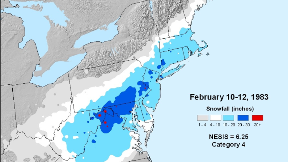
Snowfall during the February Blizzard of 1983. (Source: NOAA)
During the 1982–83 season, an extremely active and stormy pattern set up along the East Coast. Although temperatures remained generally mild, the proper alignment of moisture and cold air produced severe weather, including the major Blizzard of February 1983, which dumped nearly 17 inches of snow on Washington, D.C., bringing the season's total to 27.6 inches.
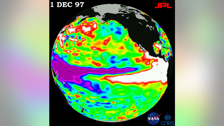
Satellite data showing the super El Niño event in December of 1997. (Source: NASA)
By contrast, the 1997–98 super El Niño brought one of the warmest winters on record across the eastern United States. Washington, D.C. experienced persistent rain and a distinct lack of sustained cold, resulting in its 10th warmest winter historically. Snowfall was virtually non-existent, tying the record for D.C.'s least snowy winter with just 0.1 inches of total accumulation.
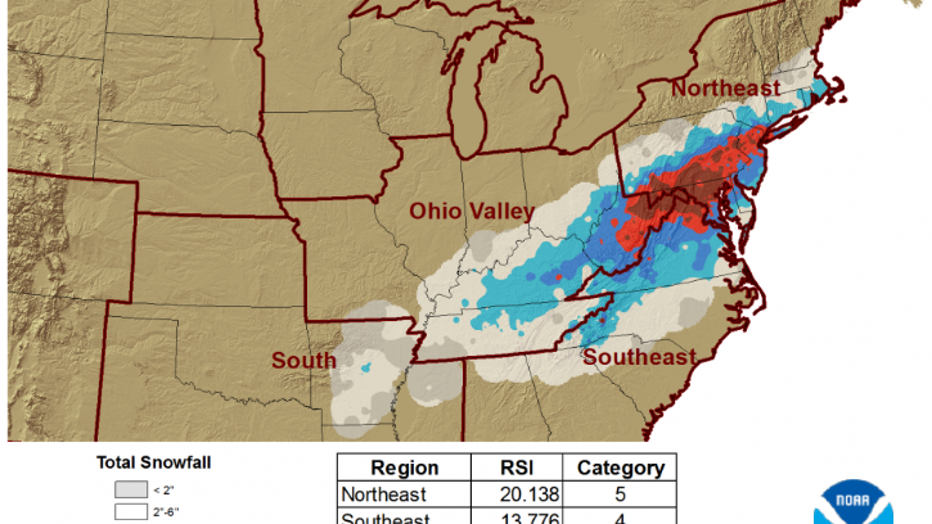
Snowfall data from the Blizzard of January 2016. (Source: NOAA)
The 2015–16 event showcased how a mild pattern can still produce blockbuster winter storms. Despite ranking as the 12th warmest winter on record for D.C. and seeing exceptionally warm temperatures nationally, the season delivered historic snowfall when key systems lined up. A massive blizzard in January 2016 dropped 18 inches of snow on D.C. (its fourth-largest on record) and an all-time record 29.2 inches on Baltimore, driving D.C.'s total seasonal snowfall to 22.2 inches.
The 'boom-or-bust' snow potential
The common denominator across all past super El Niño winters—including 1877–78—is milder-than-average overall temperatures. This indicates a high likelihood of a warm winter ahead for 2026–27.
However, half of these historic analog years still produced major, record-setting snowstorms. A warm seasonal average does not preclude severe winter weather if an active storm track aligns with a brief injection of arctic air.
Because a super El Niño creates a moisture-rich atmosphere, the potential volume of precipitation increases. While the overall "window" for freezing temperatures may be shorter, any major storm that does align with cold air has a higher potential to become a historic snowfall event. As a result, the upcoming winter is shaping up to be a boom-or-bust scenario for snowfall in the Mid-Atlantic—either producing significant accumulation from one or two major systems or yielding very little snow for the entire season.
The bottom line
Big picture view:
A developing super El Niño is expected to significantly shape weather patterns across the Mid-Atlantic through the fall and winter seasons.
- Late summer/early fall: Continued humid conditions with active thunderstorm patterns.
- Autumn: Wetter-than-average conditions with delayed onset of winter cold.
- Drought: Ongoing, gradual improvement in soil moisture and rainfall deficits.
- Hurricanes: A generally quieter Atlantic hurricane season overall, though coastal threat remains.
- Winter 2026–27: Milder-than-average temperatures paired with an active coastal storm track, leading to mostly rain events, but maintaining high potential for a "boom-or-bust" major snowstorm.
The Source: Information from FOX 5 D.C. Meteorologist Mike Thomas.