

Hazy, hot Friday with highs in the 90s; Flash Flood Watch ahead of possible afternoon storms
(FOX 5 DC) - We finish the work week the way we started it: Sunny, hot, and humid with scattered afternoon and evening storms.
Temperatures head for the low to mid-90s again feeling like the triple digits thanks to the heavy humidity.

FOX 5 Weather forecast for Friday, August 27
Tucker Barnes has the FOX 5 Weather forecast for Friday, August 27
After 3 p.m. through the evening hours we are on the lookout for more storms, some of which may be severe.
With the heavy storms the last few days, and the threat for more localized heavy downpours in storms later today, parts of the region -- specifically the Interstate 95 corridor from D.C. up through Baltimore – have been placed under a FLASH FLOOD WATCH beginning at 1 p.m. this afternoon.
Download the FOX 5 DC News App for Local Breaking News and Weather
The Storm Prediction Center has outlooked our area for the marginal risk for severe storms. Like yesterday, be prepared for heavy rain and damaging winds if you hear a warning issued for your area.
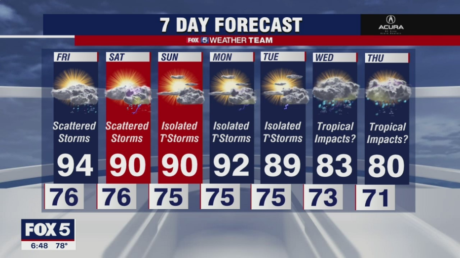
Not much relief over the weekend although temperatures may be closer to 90. We expect a few more pop-up storms over the weekend as well.
Another big weather headline this weekend will be the approach of "Ida" to the central Gulf Coast. The National Hurricane Center is forecasting "Ida" to become a category 2 hurricane as it approaches the Louisiana coastline on Sunday.