

Thanksgiving travel faces challenges from budding cross-country storm

US officials prepare for Thanksgiving travel
From air travel to public safety, authorities across America say they are prepared for the US travel season -- With Thanksgiving the kickoff in just a few days.
Thanksgiving travel trouble is brewing as a storm system begins to sweep across the U.S. this weekend and tracks eastward in the days leading up to the holiday.
The storm began off the West Coast and is expected to produce wet weather along its cross-country journey over the next several days.
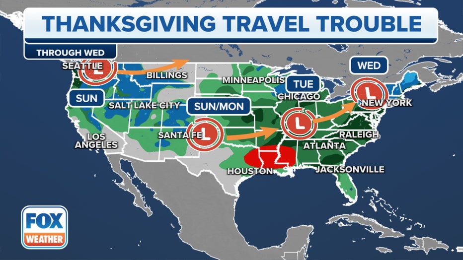
The Thanksgiving travel weather outlook. Green represents chances for rain, while blue represents chances of snow. Red represents chances for severe weather. (FOX Weather)
On Sunday, The Pacific Northwest will deal with a rainy day with snow likely in the higher elevations of the mountains as a storm system comes ashore, making for treacherous travel across some the higher mountain passes of the Cascades in Oregon and southern Washington.
In the Plains, a second system will bring isolated thunderstorms over portions of Oklahoma. Widespread instability appears not to be in the cards, which is usually an important ingredient for a severe weather outbreak. However, computer forecast models show abundant moisture will be in place, which is another catalyst for shower and thunderstorm activity. Any storms could result in some gusty winds and small hail.
Communities around Oklahoma City and Tulsa have the highest potential for thunderstorm activity.
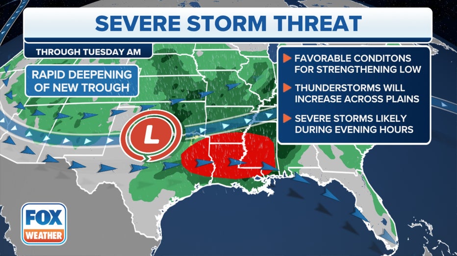
The setup for severe storms early in the week. (FOX Weather)
The wet weather is expected to slide eastward during the busy Thanksgiving travel week. Here's an overview of each day's forecast.
Monday: Severe storm threat pushes into Lower Mississippi Valley
On Monday, wet weather will be possible from the Rockies through the Gulf Coast into the Tennessee and Ohio valleys and the Southeast.
The weather with the most potential for creating problems will be along the Gulf Coast. Severe thunderstorms will be possible Monday afternoon and into Monday night from East Texas into parts of the lower Mississippi Valley and Southeast, according to the FOX Forecast Center.
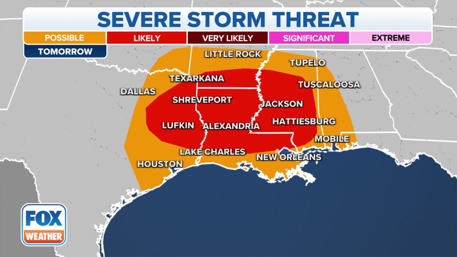
The severe storm threat on Monday, Nov. 20, 2023. (FOX Weather)
Damaging wind gusts and a few tornadoes are expected to be the main concerns, though isolated hail will also be possible. Communities such as Jackson in Mississippi and Baton Rouge in Louisiana are in a Level 2 out of 5 on NOAA's Storm Prediction Center's severe weather risk scale.
THE 5-POINT SEVERE THUNDERSTORM RISK CATEGORY SCALE EXPLAINED
Elsewhere, it's a rainy day in the Plains with some snow possible in the Colorado Rockies.
Tuesday: More widespread travel impacts expected
On Tuesday, the powerful storm shifts east, creating what is forecast to be the worst day of the week for impacting travel.
Widespread rain is expected across much of the Eastern U.S. as the main system moves into the Ohio Valley, and then a secondary system from Canada will dive south, providing an extra boost to the ongoing storm.
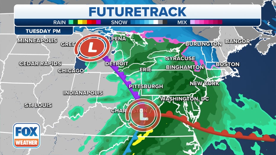
The FOX Weather Futuretrack for Tuesday, Nov. 21, 2023.(FOX Weather)
This will allow for light snow to break out on the northern edge of the storm across the Great Lakes and in the higher terrain of upstate New York and northern New England, but it's too soon to determine how much accumulation is expected, according to the FOX Forecast Center.
WHAT ARE THE ODDS OF A WHITE THANKSGIVING?
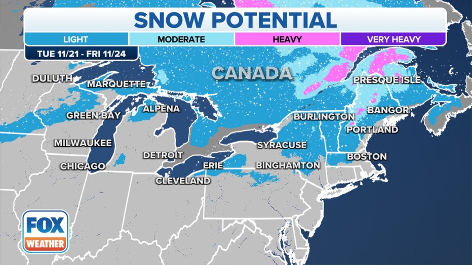
Snow potential for Tuesday, Nov. 21, 2023.(FOX Weather)
This storm is pacific in origin, with limited cold air to work with, so it will feature mostly rain elsewhere.
The rain will reach the Interstate 95 corridor in the mid-Atlantic and Northeast on Tuesday afternoon or evening and slide east across the region into Wednesday morning.
Meanwhile, communities between New Orleans and Nashville, Tennessee, face the possibility of seeing an inch or two of rainfall, which is much needed for the drought-stricken region.
THANKSGIVING DINNER MAY COST A BIT MORE THANKS TO EXTREME WEATHER EVENTS ACROSS THE U.S.
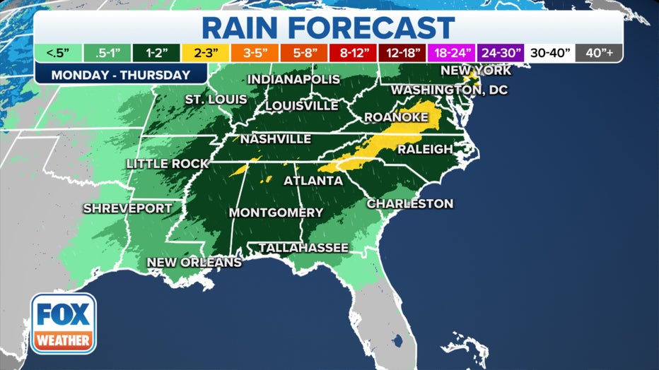
The rainfall forecast between Monday, Nov. 20, and Thursday, Nov. 23, 2023.(FOX Weather)
Wednesday and Thanksgiving: Gradually drying out
On Wednesday, one of the biggest travel days of the year, the storm system is expected to gradually slide off the East Coast, drying out the rain from west to east during the day in the Northeast, though forecast models diverge on how fast the system moves east and off the coast.
A slower system would continue to bring rain to much of the Eastern Seaboard, whereas a faster system could lead to dry conditions for Wednesday, the FOX Forecast Center says.
Thanksgiving Day overall looks calm for much of the nation, with just some snow across the Northern Rockies and periods of rain in Texas.
TRANSPORTATION SECURITY ADMINISTRATION ANTICIPATES RECORD THANKSGIVING HOLIDAY TRAVEL SEASON
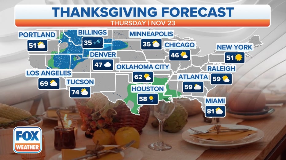
Thanksgiving forecast.(FOX Weather)
But forecast models are diverging in their long-range forecasts for what happens after Thanksgiving and people begin their treks home. There is a possibility that a second system develops in the wake of Wednesday's storm, traveling across the Central U.S. on Friday and impacting the Eastern U.S. next weekend. The details will become better defined in the coming days.
Keep tabs on the forecast for your Thanksgiving destination using the FOX Weather app. Just open the app and tap the Events tab to get started.