

Snow totals for DC, Maryland, Virginia, and West Virginia from January 5-6, 2025

DC snow forecast: Record snowfall at BWI, Dulles Monday
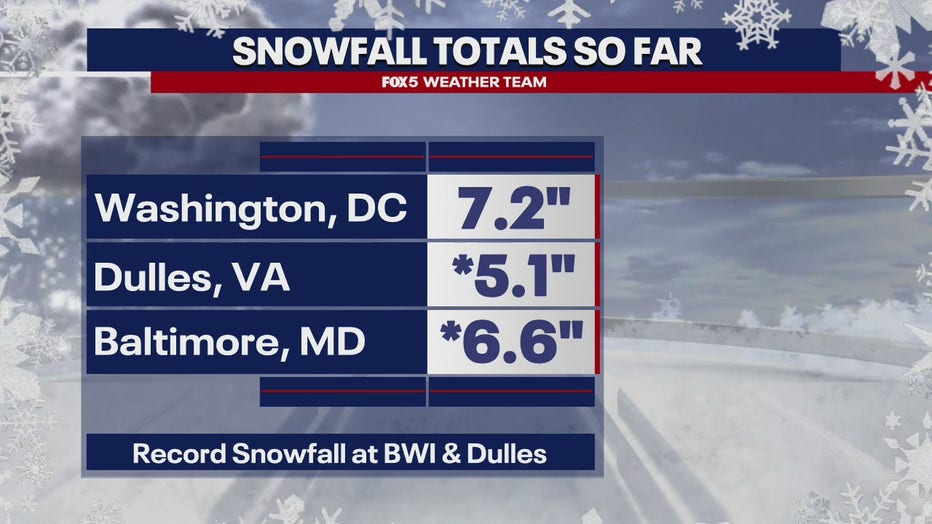
A record snowfall at Baltimore/Washington International Thurgood Marshall Airport (BWI) and Washington Dulles International Airport (IAD) on Monday. A bitter cold day ahead with blowing snow possible.
WASHINGTON - The first significant snowfall of the season broke records across the Washington, D.C., Maryland, and Virginia region on Monday. Here’s a look at snow totals near you from the National Weather Service.
Summary: An area of low pressure brought a widespread swath of 6 to 12" of snow from the Alleghenies through the Shenandoah Valley across the DC metro and into Southern Maryland. This was the most snowfall in one location from a single snow event since January 2022 for many areas. This storm impacted the region with numerous closures for several days.
DMV SNOW TOTALS | STORM TOTAL SNOWFALL
DC SNOW TOTALS
Washington, DC snow totals
Washington 3 NE: 8.3 inches (7:00 AM, 1/07) - CoCoRaHS
Anacostia 1 N: 7.7 inches (3:43 PM, 1/06) - Public
Washington 1 E: 6.8 inches (10:00 PM, 1/06) - Trained Spotter
Anacostia SSE: 6.5 inches (5:15 PM, 1/06) - Trained Spotter
Adams Morgan 1 SSE: 6.5 inches (7:30 PM, 1/06) - Trained Spotter
Anacostia 1 S: 6.5 inches (9:30 PM, 1/06) - Trained Spotter
American University: 6.3 inches (12:24 PM, 1/06) - Broadcast Media
School closures, delays for DC, Maryland, Virginia for Tuesday, January 7
Snow Totals for DC, Maryland, Virginia, and West Virginia from January 6
MARYLAND SNOW TOTALS
Allegany County snow totals
Frostburg: 7.3 inches (7:00 AM, 1/07) - Co-Op Observer
Wolfe Mill 2 NNE: 6.5 inches (5:21 PM, 1/06) - Trained Spotter
Ridgeley 1 NW: 6.5 inches (8:39 PM, 1/06) - Trained Spotter
Potomac Park 2 NW: 6.2 inches (5:00 PM, 1/06) - Dept of Highways
Cumberland: 5.2 inches (7:00 AM, 1/07) - Co-Op Observer
Bellegrove 1 SSE: 4.5 inches (8:16 PM, 1/06) - Trained Spotter
Anne Arundel County snow totals
Londontowne 1 SSE: 10.3 inches (11:30 PM, 1/06) - NWS Employee
Crownsville 3 SSW: 9.7 inches (7:00 AM, 1/07) - Trained Spotter
Galesville 1 W: 9.5 inches (9:08 AM, 1/07) - NWS Employee
Annapolis 2 SW: 9.5 inches (4:45 PM, 1/06) - NWS Employee
Annapolis 1 S: 9.2 inches (6:30 AM, 1/07) - Trained Spotter
Birdsville WSW: 9.1 inches (7:00 AM, 1/07) - CoCoRaHS
Birdsville: 9.1 inches (12:00 AM, 1/07) - NWS Employee
Severn 2 SSW: 9.0 inches (8:21 AM, 1/07) - CoCoRaHS
Parole 2 NE: 9.0 inches (7:00 AM, 1/07) - Trained Spotter
Annapolis 1 SE: 9.0 inches (8:15 AM, 1/07) - CoCoRaHS
Deale 1 SE: 9.0 inches (7:00 AM, 1/07) - CoCoRaHS
Annapolis 2 S: 8.5 inches (4:45 PM, 1/06) - NWS Employee
Cape St. Claire: 8.3 inches (11:50 AM, 1/06) - Trained Spotter
Crofton 2 NNE: 7.9 inches (7:00 AM, 1/07) - NWS Employee
Crofton 1 SSE: 7.8 inches (7:00 AM, 1/07) - CoCoRaHS
Green Haven 1 ESE: 7.5 inches (6:15 AM, 1/07) - Trained Spotter
Churchton ENE: 7.5 inches (1:30 PM, 1/06) - Trained Spotter
Riva 1 NE: 7.5 inches (4:11 PM, 1/06) - Public
Hillsmere Shores 1 N: 7.4 inches (4:04 PM, 1/06) - Trained Spotter
Chelsea Beach: 7.4 inches (11:00 PM, 1/06) - Trained Spotter
Pasadena 1 ENE: 7.3 inches (9:05 PM, 1/06) - Trained Spotter
Parole: 7.2 inches (5:00 PM, 1/06) - Dept of Highways
Odenton 1 S: 7.2 inches (11:00 AM, 1/06) - Trained Spotter
Baltmore-Washington: 7.0 inches (5:00 PM, 1/06) - Dept of Highways
Odenton 1 WNW: 7.0 inches (1:45 PM, 1/06) - Trained Spotter
Bwi Airport: 6.6 inches (1:00 AM, 1/07) - Official NWS Obs
Glen Burnie 1 WSW: 6.1 inches (10:04 PM, 1/06) - Trained Spotter
Baltimore County snow totals
Owings Mills: 7.1 inches (5:00 PM, 1/06) - Dept of Highways
Catonsville 1 SSE: 6.5 inches (9:00 PM, 1/06) - Trained Spotter
Edgemere SE: 6.0 inches (6:28 AM, 1/07) - Trained Spotter
Oella 2 NNE: 5.7 inches (10:29 PM, 1/06) - Trained Spotter
White Marsh 2 E: 5.5 inches (11:00 PM, 1/06) - Trained Spotter
Rosedale 2 S: 5.0 inches (7:00 AM, 1/07) - HADS
Glyndon 1 WSW: 4.9 inches (11:00 PM, 1/06) - Trained Spotter
White Marsh 2 ESE: 4.7 inches (7:00 AM, 1/07) - CoCoRaHS
Towson 1 SW: 4.4 inches (8:30 AM, 1/07) - CoCoRaHS
Timonium NE: 4.3 inches (7:00 AM, 1/07) - CoCoRaHS
Upper Falls 1 NNE: 4.2 inches (11:00 PM, 1/06) - Trained Spotter
Kingsville 1 E: 4.2 inches (7:00 AM, 1/07) - CoCoRaHS
Fullerton 1 N: 4.2 inches (8:45 AM, 1/07) - Trained Spotter
Long Green 1 SW: 4.1 inches (7:00 AM, 1/07) - CoCoRaHS
Long Green 2 NW: 4.0 inches (9:00 PM, 1/06) - Trained Spotter
Reisterstown 1 NW: 3.9 inches (5:00 PM, 1/06) - CoCoRaHS
Randallstown 2 NW: 3.5 inches (3:30 PM, 1/06) - Trained Spotter
Baltimore City snow totals
Pimlico SE: 5.5 inches (6:24 AM, 1/07) - Trained Spotter
Mount Washington 1 N: 5.3 inches (8:00 AM, 1/07) - CoCoRaHS
Arlington 2 E: 5.0 inches (10:40 PM, 1/06) - Broadcast Media
Baltimore 2 SW: 4.5 inches (9:52 AM, 1/06) - NWS Employee
Baltimore Martin Sta: 4.5 inches (12:15 PM, 1/06) - Trained Spotter
Hamilton NE: 4.1 inches (6:00 AM, 1/07) - CoCoRaHS
Calvert County snow totals
Benedict 1 E: 12.2 inches (8:27 PM, 1/06) - Public
Huntingtown SW: 12.1 inches (11:15 PM, 1/06) - Trained Spotter
Chesapeake Beach: 12.0 inches (4:45 PM, 1/06) - NWS Employee
Prince Frederick 1 S: 11.6 inches (10:10 PM, 1/06) - Trained Spotter
Huntingtown 3 NNW: 11.0 inches (7:00 AM, 1/07) - CoCoRaHS
North Beach 1 W: 10.8 inches (12:30 PM, 1/06) - Trained Spotter
Prince Frederick 1 W: 10.3 inches (8:00 AM, 1/07) - CoCoRaHS
Huntingtown 3 SSW: 10.0 inches (11:58 AM, 1/06) - Trained Spotter
Dunkirk 3.2 NNE: 9.7 inches (8:00 AM, 1/07) - CoCoRaHS
Dowell 2 NE: 8.5 inches (4:00 PM, 1/06) - Trained Spotter
North Beach 2 WNW: 7.0 inches (8:00 AM, 1/06) - CoCoRaHS
Carroll County snow totals
Eldersburg 1 SE: 5.5 inches (7:00 AM, 1/07) - Trained Spotter
Eldersburg 1 E: 5.5 inches (7:00 AM, 1/07) - CoCoRaHS
Mount Airy SE: 5.5 inches (7:30 AM, 1/07) - CoCoRaHS
Sykesville 1 NNW: 5.2 inches (10:30 PM, 1/06) - NWS Employee
Watersville 1 N: 4.1 inches (1:25 PM, 1/06) - Trained Spotter
Gamber 1 WNW: 4.0 inches (10:30 PM, 1/06) - NWS Employee
Gamber 1 W: 4.0 inches (7:00 AM, 1/07) - CoCoRaHS
Marston 2 N: 3.9 inches (7:00 AM, 1/07) - CoCoRaHS
Millers 4 NE: 3.8 inches (12:00 AM, 1/07) - Co-Op Observer
Cecil County snow totals
Galena 4 NW: 4.0 inches (9:00 AM, 1/07) - CoCoRaHS
Elkton 2 W: 3.0 inches (5:00 PM, 1/06) - Dept of Highways
Elkton 5 NW: 2.9 inches (7:00 AM, 1/07) - CoCoRaHS
Pleasant Hill 2 SSE: 2.7 inches (12:34 PM, 1/06) - Trained Spotter
Charles County snow totals
Waldorf 3 S: 11.9 inches (8:00 AM, 1/07) - CoCoRaHS
Dentsville 1 SW: 10.1 inches (10:00 PM, 1/06) - Trained Spotter
Dentsville 3 WNW: 10.0 inches (12:00 PM, 1/06) - Trained Spotter
Waldorf 2 W: 9.3 inches (12:15 PM, 1/06) - Trained Spotter
Nanjemoy 5 S: 9.0 inches (7:00 AM, 1/07) - CoCoRaHS
Tompkinsville 4 WNW: 9.0 inches (12:00 AM, 1/07) - Trained Spotter
Waldorf 8 ESE: 9.0 inches (8:00 AM, 1/07) - CoCoRaHS
La Plata 2 NNW: 9.0 inches (5:00 PM, 1/06) - Dept of Highways
Indian Head: 9.0 inches (12:24 PM, 1/06) - Public
Bryantown 2 NE: 8.9 inches (7:00 AM, 1/07) - CoCoRaHS
La Plata 6 SE: 8.5 inches (11:00 AM, 1/06) - CoCoRaHS
St. Charles 1 ENE: 8.0 inches (12:29 PM, 1/06) - Trained Spotter
Welcome 2 WNW: 7.8 inches (7:35 AM, 1/07) - Trained Spotter
Charlotte Hall 2 NW: 7.5 inches (5:00 PM, 1/06) - Trained Spotter
Frederick County snow totals
Green Valley 1 WNW: 6.5 inches (8:50 PM, 1/06) - Public
Fort Ritchie 1 SSE: 6.1 inches (8:28 PM, 1/06) - Trained Spotter
Point of Rocks 1 NE: 5.7 inches (8:00 AM, 1/07) - Trained Spotter
Mount Airy 1 WSW: 5.3 inches (10:30 PM, 1/06) - Trained Spotter
New Market N: 5.3 inches (9:20 PM, 1/06) - Trained Spotter
Adamstown 1 ESE: 5.1 inches (6:00 AM, 1/07) - NWS Employee
Bloomfield 2 WSW: 5.0 inches (9:00 PM, 1/06) - NWS Employee
New Market 2 NW: 5.0 inches (8:00 PM, 1/06) - Trained Spotter
Ballenger Creek WSW: 4.7 inches (10:00 PM, 1/06) - Trained Spotter
Braddock Heights 1 N: 4.6 inches (8:16 AM, 1/06) - Trained Spotter
Ballenger Creek 1 NN: 4.2 inches (12:45 PM, 1/06) - Trained Spotter
Sabillasville 2 SSE: 4.0 inches (11:30 AM, 1/06) - Trained Spotter
Mount Pleasant 2 SSE: 4.0 inches (11:38 AM, 1/06) - Public
Lewistown 2 SSW: 3.3 inches (9:33 AM, 1/06) - Trained Spotter
Middletown: 3.2 inches (7:00 AM, 1/07) - CoCoRaHS
Garrett County snow totals
Grantsville 5 W: 14.8 inches (1:00 AM, 1/07) - Dept of Highways
Mc Henry: 12.5 inches (8:52 PM, 1/06) - Trained Spotter
Deer Park 6 NE: 8.2 inches (7:00 AM, 1/07) - Trained Spotter
Accident 4 SE: 7.2 inches (11:59 PM, 1/06) - Public
McHenry 5 SSE: 6.5 inches (8:00 AM, 1/06) - CoCoRaHS
Mc Henry 4 SW: 5.9 inches (6:00 AM, 1/07) - Co-Op Observer
Harford County snow totals
Norrisville 1 WSW: 8.0 inches (6:45 AM, 1/07) - CoCoRaHS
Kingsville 3 NNE: 7.5 inches (11:45 AM, 1/06) - CoCoRaHS
Churchville 1 SE: 4.5 inches (5:00 PM, 1/06) - Dept of Highways
Aberdeen Proving Ground: 4.0 inches (10:00 PM, 1/06) - Trained Spotter
Bynum 1 E: 3.5 inches (7:24 AM, 1/07) - Trained Spotter
Churchville 1 N: 3.5 inches (10:20 PM, 1/06) - Trained Spotter
Bel Air 2 E: 3.3 inches (7:48 AM, 1/07) - Trained Spotter
Forest Hill 3 SW: 3.3 inches (9:30 PM, 1/06) - Trained Spotter
Howard County snow totals
North Laurel 2 ESE: 7.8 inches (7:00 AM, 1/07) - CoCoRaHS
Simpsonville 1 SSE: 7.8 inches (10:30 PM, 1/06) - Trained Spotter
Laurel 3 NNE: 7.8 inches (10:15 PM, 1/06) - Trained Spotter
Simpsonville E: 7.8 inches (11:15 PM, 1/06) - Trained Spotter
Columbia: 7.7 inches (8:00 AM, 1/07) - NWS Employee
Savage 1 ESE: 7.5 inches (7:15 PM, 1/06) - Trained Spotter
Columbia 3 SSE: 7.3 inches (7:00 AM, 1/07) - CoCoRaHS
Laurel 1 NNE: 7.2 inches (6:00 AM, 1/07) - CoCoRaHS
Elkridge 2 W: 7.2 inches (10:15 PM, 1/06) - Trained Spotter
Clarksville 2 N: 7.1 inches (11:00 PM, 1/06) - Trained Spotter
Simpsonville 2 NNW: 7.0 inches (11:50 PM, 1/06) - Trained Spotter
Gaither 2 SSE: 7.0 inches (7:40 AM, 1/07) - Trained Spotter
Laurel 1 N: 6.8 inches (4:45 PM, 1/06) - NWS Employee
Sykesville 2 SSE: 6.8 inches (7:00 AM, 1/07) - CoCoRaHS
Simpsonville: 6.5 inches (5:08 PM, 1/06) - Trained Spotter
Daniels 1 S: 6.5 inches (10:17 AM, 1/06) - Trained Spotter
Ellicott City: 6.5 inches (11:00 PM, 1/06) - Broadcast Media
Elkridge: 6.4 inches (8:06 AM, 1/07) - NWS Employee
Elkridge 2 ESE: 6.1 inches (2:24 PM, 1/06) - Trained Spotter
Ellicott City 1 SW: 5.9 inches (8:15 AM, 1/07) - Trained Spotter
Elkridge 2 WSW: 5.8 inches (6:00 PM, 1/06) - Trained Spotter
Ilchester 1 W: 5.5 inches (7:32 PM, 1/06) - Trained Spotter
Hanover ENE: 5.5 inches (10:00 AM, 1/06) - Trained Spotter
Columbia 2 NW: 5.5 inches (11:00 AM, 1/06) - Trained Spotter
Historic Ellicott City: 5.5 inches (10:57 AM, 1/06) - NWS Employee
Columbia 1 N: 5.5 inches (8:14 PM, 1/06) - Trained Spotter
Columbia 2 NNW: 5.3 inches (7:37 AM, 1/07) - CoCoRaHS
Montgomery County snow totals
Potomac: 8.3 inches (9:38 PM, 1/06) - Emergency Manager
Langley Park 1 W: 8.1 inches (12:00 AM, 1/07) - Trained Spotter
Glen Echo 1 WNW: 8.0 inches (7:25 PM, 1/06) - Emergency Manager
North Potomac 4 N: 7.5 inches (7:00 AM, 1/07) - CoCoRaHS
Germantown 2 WSW: 7.5 inches (11:00 PM, 1/06) - Trained Spotter
Glenmont 1 S: 7.5 inches (7:25 PM, 1/06) - Emergency Manager
Norbeck 1 ESE: 7.3 inches (7:00 AM, 1/07) - CoCoRaHS
Poolesville NE: 7.3 inches (10:50 PM, 1/06) - Trained Spotter
Colesville 2 W: 7.3 inches (7:00 AM, 1/07) - CoCoRaHS
Rockville: 7.2 inches (9:51 PM, 1/06) - NWS Employee
Garrett Park 1 ENE: 7.1 inches (11:00 PM, 1/06) - Trained Spotter
Washington Grove 1 N: 7.0 inches (3:00 PM, 1/06) - Trained Spotter
Rockville 1 SSE: 7.0 inches (10:10 PM, 1/06) - Trained Spotter
Garrett Park 2 NW: 7.0 inches (12:05 AM, 1/07) - Trained Spotter
Potomac 1 NNW: 7.0 inches (7:00 AM, 1/07) - CoCoRaHS
Damascus 3 SSW: 7.0 inches (8:47 PM, 1/06) - Co-Op Observer
Potomac 3 NE: 7.0 inches (7:00 AM, 1/07) - CoCoRaHS
Colesville 1 SE: 7.0 inches (1:15 PM, 1/06) - Trained Spotter
Gaithersburg 2 E: 7.0 inches (7:17 AM, 1/07) - NWS Employee
Silver Spring 6 NNE: 6.9 inches (5:03 AM, 1/07) - CoCoRaHS
Colesville: 6.8 inches (11:25 AM, 1/06) - Trained Spotter
Damascus 1 S: 6.8 inches (7:00 AM, 1/07) - CoCoRaHS
Montgomery Village 1: 6.6 inches (6:30 AM, 1/07) - CoCoRaHS
Gaithersburg 1 SW: 6.6 inches (10:03 PM, 1/06) - Trained Spotter
Ashton-Sandy Springs: 6.5 inches (7:00 AM, 1/07) - CoCoRaHS
Four Corners 1 N: 6.5 inches (2:24 AM, 1/06) - Trained Spotter
Gaithersburg 3 NE: 6.4 inches (7:00 AM, 1/07) - CoCoRaHS
Gaithersburg 1 E: 6.3 inches (12:39 PM, 1/06) - Public
Four Corners 2 NW: 6.0 inches (12:34 PM, 1/06) - Trained Spotter
Damascus 1 SE: 6.0 inches (7:00 AM, 1/06) - Trained Spotter
Laytonsville 5 NNW: 6.0 inches (7:00 AM, 1/06) - CoCoRaHS
White Oak 1 N: 6.0 inches (7:00 AM, 1/07) - CoCoRaHS
Prince Georges County snow totals
Fort Washington 1 SSW: 10.5 inches (7:00 AM, 1/07) - CoCoRaHS
Marlton 1 WSW: 10.2 inches (7:45 AM, 1/07) - Trained Spotter
Tantallon 3 SE: 8.8 inches (2:04 PM, 1/06) - Trained Spotter
Glenn Dale 1 NNE: 8.5 inches (10:00 PM, 1/06) - NWS Employee
Beltsville 1 NNW: 8.0 inches (8:30 AM, 1/07) - CoCoRaHS
Bowie 2 SSE: 8.0 inches (5:10 PM, 1/06) - NWS Employee
Suitland 2 SE: 7.5 inches (7:00 AM, 1/07) - CoCoRaHS
University Park 1 E: 7.2 inches (10:55 PM, 1/06) - NWS Office
Greenbelt 1 SE: 7.0 inches (9:58 AM, 1/07) - Trained Spotter
Greenbelt 1 N: 7.0 inches (7:00 AM, 1/07) - CoCoRaHS
Savage 1 WNW: 6.2 inches (4:45 PM, 1/06) - Trained Spotter
College Park 1 S: 6.1 inches (8:00 AM, 1/07) - Trained Spotter
St. Marys County snow totals
Sandgates 1 S: 9.8 inches (9:54 AM, 1/07) - Trained Spotter
California 2 W: 9.8 inches (12:30 PM, 1/06) - Trained Spotter
Leonardtown: 9.0 inches (11:30 AM, 1/06) - Trained Spotter
Callaway 2 W: 8.5 inches (11:50 AM, 1/06) - Trained Spotter
Hollywood 3 S: 8.3 inches (10:20 PM, 1/06) - Trained Spotter
Clements 3 E: 8.0 inches (5:00 PM, 1/06) - Dept of Highways
Leonardtown SSE: 7.5 inches (11:26 AM, 1/06) - Trained Spotter
Great Mills 1 NNE: 7.5 inches (11:47 AM, 1/06) - Trained Spotter
Leonardtown 1 SW: 7.4 inches (8:28 AM, 1/06) - Trained Spotter
Ridge 1 N: 7.3 inches (7:00 AM, 1/07) - CoCoRaHS
Ridge 1 ENE: 7.3 inches (7:00 AM, 1/07) - Trained Spotter
Washington County snow totals
Hagerstown 1 ENE: 7.7 inches (7:00 AM, 1/07) - CoCoRaHS
Boonsboro 3 NNE: 5.3 inches (10:00 PM, 1/06) - Trained Spotter
Funkstown 2 SSW: 5.0 inches (9:02 PM, 1/06) - Public
Hancock 1 ESE: 4.5 inches (7:00 AM, 1/07) - CoCoRaHS
Williamsport 3 ENE: 4.3 inches (6:00 AM, 1/07) - CoCoRaHS
Maugansville WSW: 4.3 inches (9:30 PM, 1/06) - Trained Spotter
Hagerstown 4 NNW: 4.3 inches (7:00 AM, 1/07) - CoCoRaHS
Pecktonville 3 NNW: 4.0 inches (7:00 AM, 1/07) - NWS Employee
VIRGINIA SNOW TOTALS
Albemarle County snow totals
Earlysville 2 W: 5.8 inches (12:45 PM, 1/06) - Public
Hollymead 1 ENE: 5.5 inches (8:30 AM, 1/06) - Trained Spotter
Eheart 3 SSW: 5.4 inches (9:12 AM, 1/06) - Trained Spotter
Hollymead 3 NNW: 5.2 inches (7:30 AM, 1/07) - CoCoRaHS
Crozet 1 W: 5.0 inches (8:00 AM, 1/06) - CoCoRaHS
Afton 1 ENE: 4.8 inches (8:00 AM, 1/06) - CoCoRaHS
Charlottesville: 4.5 inches (9:52 AM, 1/06) - Trained Spotter
Arlington County snow totals
Falls Church 1 E: 9.3 inches (9:44 PM, 1/06) - Trained Spotter
Rosslyn: 7.8 inches (10:30 PM, 1/06) - Trained Spotter
Rosslyn 1 S: 7.3 inches (10:00 PM, 1/06) - Trained Spotter
Reagan National Apt: 7.2 inches (1:00 AM, 1/07) - Official NWS Obs
Baileys Crossroads 1: 6.7 inches (7:30 PM, 1/06) - Trained Spotter
Augusta County snow totals
Fishersville 2 NNW: 8.0 inches (9:00 PM, 1/06) - Trained Spotter
Sugar Grove 5 SE: 7.0 inches (8:50 AM, 1/06) - Broadcast Media
Fort Defiance 3 ESE: 6.5 inches (7:00 AM, 1/07) - CoCoRaHS
Verona 3 NNE: 6.0 inches (8:50 AM, 1/06) - Broadcast Media
Weyers Cave ESE: 6.0 inches (7:00 AM, 1/06) - CoCoRaHS
Stuarts Draft 2 S: 5.9 inches (11:15 AM, 1/06) - CoCoRaHS
Verona 3 NNW: 5.8 inches (7:00 AM, 1/06) - CoCoRaHS
Fort Defiance 4 SE: 5.5 inches (7:00 AM, 1/06) - CoCoRaHS
Verona 3 ENE: 5.5 inches (7:00 AM, 1/06) - CoCoRaHS
Weyers Cave 1 SSW: 5.4 inches (8:45 AM, 1/06) - Trained Spotter
Mount Solon 4 SSE: 5.1 inches (7:30 AM, 1/07) - CoCoRaHS
Mint Spring 3 SSE: 5.0 inches (10:00 AM, 1/06) - Trained Spotter
City of Alexandria snow totals
National Harbor 1 NW: 8.0 inches (11:45 PM, 1/06) - Trained Spotter
Alexandria 2 W: 7.7 inches (7:00 AM, 1/07) - CoCoRaHS
Alexandria 1 W: 7.5 inches (9:40 PM, 1/06) - Trained Spotter
Rose Hill 2 NNW: 7.2 inches (8:20 AM, 1/06) - Trained Spotter
City of Charlottesville snow totals
Charlottesville 1 NN: 4.2 inches (9:00 AM, 1/06) - Trained Spotter
Newcomb Hall 1 SW: 3.8 inches (8:05 AM, 1/06) - Trained Spotter
Newcomb Hall 3 SSW: 3.5 inches (7:00 AM, 1/06) - Trained Spotter
City of Fairfax snow totals
Fairfax 1 N: 8.0 inches (7:00 AM, 1/07) - CoCoRaHS
City of Falls Church snow totals
Falls Church 1 E: 8.2 inches (7:00 PM, 1/06) - Trained Spotter
City of Fredericksburg snow totals
Fredericksburg 1 ENE: 6.3 inches (7:45 AM, 1/06) - CoCoRaHS
Dunavant 1 S: 6.0 inches (8:00 AM, 1/06) - Trained Spotter
Fredericksburg 2 E: 5.0 inches (5:30 AM, 1/06) - Trained Spotter
City of Harrisonburg snow totals
Harrisonburg 2 N: 7.5 inches (9:00 AM, 1/06) - CoCoRaHS
Harrisonburg 2 NNW: 5.5 inches (7:00 AM, 1/06) - CoCoRaHS
City of Manassas snow totals
Independent Hill 2 E: 11.0 inches (11:00 PM, 1/06) - Trained Spotter
Manassas 1 SW: 9.0 inches (9:00 AM, 1/07) - Co-Op Observer
Manassas Park 1 SW: 8.2 inches (3:12 AM, 1/07) - Trained Spotter
City of Staunton snow totals
Staunton Water Plant: 12.0 inches (8:00 AM, 1/07) - Co-Op Observer
Staunton 1 WNW: 6.0 inches (7:00 AM, 1/06) - CoCoRaHS
Staunton 2 S: 6.0 inches (11:50 AM, 1/06) - Trained Spotter
Staunton 1 WSW: 5.9 inches (6:45 AM, 1/07) - CoCoRaHS
City of Waynesboro snow totals
Waynesboro 1 S: 5.0 inches (9:00 PM, 1/06) - Trained Spotter
Waynesboro: 4.5 inches (9:00 AM, 1/06) - Trained Spotter
Waynesboro 1 SSW: 4.0 inches (11:30 AM, 1/06) - Trained Spotter
City of Winchester snow totals
Winchester 1 NNE: 4.0 inches (9:50 AM, 1/07) - Trained Spotter
Clarke County snow totals
Berryville 1 NNW: 6.1 inches (9:45 PM, 1/06) - Trained Spotter
Mount Weather: 5.0 inches (7:00 AM, 1/07) - Co-Op Observer
Culpeper County snow totals
Culpeper 1 W: 9.8 inches (9:15 PM, 1/06) - Trained Spotter
Culpeper 2 WNW: 8.8 inches (7:15 AM, 1/07) - CoCoRaHS
Rixeyville 3 N: 8.5 inches (8:05 AM, 1/07) - CoCoRaHS
Cardova 2 NW: 8.0 inches (6:55 PM, 1/06) - Trained Spotter
Culpeper 2 NNE: 7.3 inches (8:00 AM, 1/06) - CoCoRaHS
Cardova 2 SSE: 7.0 inches (5:30 PM, 1/06) - CoCoRaHS
Culpeper 6 WNW: 6.8 inches (8:00 AM, 1/06) - CoCoRaHS
Jeffersonton: 6.0 inches (5:37 AM, 1/06) - Public
Fairfax County snow totals
Alexandria 6 SSW: 10.6 inches (7:00 AM, 1/07) - CoCoRaHS
Newington: 10.0 inches (11:00 PM, 1/06) - NWS Employee
Burke 2 S: 9.6 inches (10:13 PM, 1/06) - Public
Hybla Valley 1 ESE: 9.5 inches (9:47 PM, 1/06) - Trained Spotter
Lorton: 9.5 inches (10:00 PM, 1/06) - NWS Employee
West Springfield 2 W: 9.3 inches (10:10 PM, 1/06) - Trained Spotter
Fairfax Station 1 SE: 9.2 inches (11:45 PM, 1/06) - Trained Spotter
Springfield 2 SW: 9.2 inches (7:00 AM, 1/07) - CoCoRaHS
Centreville 3 SSE: 9.0 inches (9:00 PM, 1/06) - Trained Spotter
Rose Hill ENE: 9.0 inches (9:45 PM, 1/06) - Trained Spotter
Vienna: 8.7 inches (7:00 AM, 1/07) - Co-Op Observer
Fairfax NE: 8.1 inches (10:40 PM, 1/06) - Public
Fairfax 1 SW: 8.0 inches (11:00 PM, 1/06) - Emergency Manager
Fairfax 1 N: 8.0 inches (10:45 PM, 1/06) - NWS Employee
Wolf Trap 2 WSW: 8.0 inches (11:00 PM, 1/06) - Public
Chantilly 2 ENE: 7.8 inches (9:30 PM, 1/06) - Trained Spotter
Franconia 1 SSE: 7.8 inches (2:35 PM, 1/06) - CoCoRaHS
Falls Church 2 W: 7.7 inches (7:00 AM, 1/07) - CoCoRaHS
Fairfax 3 W: 7.5 inches (7:00 AM, 1/07) - CoCoRaHS
The I-395 And I-495 1: 7.5 inches (9:51 PM, 1/06) - Trained Spotter
Oakton E: 7.0 inches (8:00 AM, 1/07) - CoCoRaHS
Mount Vernon NW: 6.8 inches (4:34 AM, 1/06) - CoCoRaHS
Chantilly 1 SE: 6.5 inches (8:48 PM, 1/06) - Trained Spotter
Fairfax 3 SSE: 6.5 inches (7:00 AM, 1/07) - CoCoRaHS
Vienna 3 N: 6.4 inches (7:00 AM, 1/07) - CoCoRaHS
Alexandria 7 S: 6.3 inches (7:00 AM, 1/06) - CoCoRaHS
Centreville W: 6.3 inches (10:00 PM, 1/06) - Trained Spotter
Herndon 1 NNE: 6.2 inches (6:00 AM, 1/07) - NWS Employee
Fauquier County snow totals
Broad Run 3 SSW: 9.6 inches (7:00 AM, 1/07) - CoCoRaHS
Marshall 8 SW: 8.6 inches (7:00 AM, 1/07) - CoCoRaHS
Warrenton 3 SE: 8.0 inches (7:00 AM, 1/06) - CoCoRaHS
Greenwich 1 W: 7.0 inches (12:28 PM, 1/06) - NWS Employee
Frederick County snow totals
Wilde Acres 1 NNW: 6.0 inches (9:58 AM, 1/07) - Trained Spotter
Winchester: 6.0 inches (7:00 AM, 1/07) - Trained Spotter
Winchester 3 E: 5.6 inches (8:50 PM, 1/06) - Trained Spotter
Cross Junction 1 WSW: 5.2 inches (9:22 PM, 1/06) - Trained Spotter
Cedar Hill 4 NNW: 4.9 inches (8:12 PM, 1/06) - Trained Spotter
Stephens City 2 E: 4.8 inches (12:00 AM, 1/07) - CoCoRaHS
Winchester 2 SE: 4.3 inches (12:00 PM, 1/06) - Trained Spotter
Greene County snow totals
Stanardsville 1 SE: 7.5 inches (9:15 AM, 1/06) - Emergency Manager
Quinque 2 WSW: 6.5 inches (8:40 AM, 1/06) - Trained Spotter
Stanardsville: 6.0 inches (12:19 PM, 1/06) - Trained Spotter
Quinque 2 N: 5.9 inches (8:15 AM, 1/06) - Trained Spotter
Highland County snow totals
Monterey 1 SW: 9.6 inches (5:15 AM, 1/07) - CoCoRaHS
Mill Gap 1 SW: 7.5 inches (6:00 AM, 1/07) - Co-Op Observer
Monterey 7 SSW: 7.0 inches (7:00 AM, 1/07) - CoCoRaHS
Monterey 2 WSW: 7.0 inches (1:38 PM, 1/06) - Trained Spotter
King George County snow totals
King George 1 NE: 5.5 inches (5:00 PM, 1/06) - Trained Spotter
Loudoun County snow totals
Ashburn 1 W: 7.6 inches (8:47 PM, 1/06) - Public
Lovettsville 3 ESE: 7.4 inches (6:00 AM, 1/07) - CoCoRaHS
Arcola 1 NNE: 7.0 inches (9:23 PM, 1/06) - Trained Spotter
Leesburg 2 E: 6.8 inches (9:45 PM, 1/06) - Trained Spotter
Ashburn N: 6.5 inches (7:00 AM, 1/07) - CoCoRaHS
Lucketts 3 S: 6.5 inches (1:25 PM, 1/06) - Trained Spotter
Arcola 3 S: 6.5 inches (10:00 PM, 1/06) - Trained Spotter
Leesburg 2 NNE: 6.3 inches (8:33 AM, 1/07) - CoCoRaHS
Bloomery 3 ESE: 6.2 inches (10:00 PM, 1/06) - Trained Spotter
Leesburg 4 W: 6.0 inches (8:30 AM, 1/07) - CoCoRaHS
Arcola 2 SSE: 6.0 inches (6:21 PM, 1/06) - NWS Employee
Dulles International: 6.0 inches (12:00 AM, 1/07) - Official NWS Obs
Round Hill 3 WSW: 5.9 inches (6:27 AM, 1/07) - CoCoRaHS
Countryside 3 ESE: 5.7 inches (7:25 PM, 1/06) - Trained Spotter
Countryside 2 WNW: 5.6 inches (9:55 AM, 1/06) - Trained Spotter
Countryside 2 ESE: 5.5 inches (6:55 PM, 1/06) - Trained Spotter
Hillsboro 3 NE: 5.5 inches (11:15 PM, 1/06) - Trained Spotter
Leesburg 2 WSW: 5.3 inches (8:00 AM, 1/07) - Trained Spotter
Madison County snow totals
Madison 7 NNW: 8.7 inches (7:00 AM, 1/07) - CoCoRaHS
Madison 5 NNW: 7.8 inches (8:00 AM, 1/07) - CoCoRaHS
Auburn 3 E: 7.0 inches (5:00 PM, 1/06) - Trained Spotter
Madison 2 ESE: 6.5 inches (3:29 PM, 1/06) - Trained Spotter
Nelson County snow totals
Nellysford 2 N: 6.0 inches (9:00 AM, 1/06) - CoCoRaHS
Lovingston: 4.0 inches (9:55 AM, 1/06) - Emergency Manager
Orange County snow totals
Burr Hill 3 SSE: 6.1 inches (11:29 AM, 1/06) - Public
Orange 1 NNW: 6.0 inches (8:50 AM, 1/06) - Trained Spotter
Somerset: 6.0 inches (8:00 AM, 1/06) - Co-Op Observer
Barboursville 1 NW: 5.5 inches (9:30 AM, 1/06) - CoCoRaHS
Page County snow totals
Honeyville 1 ESE: 8.5 inches (9:00 PM, 1/06) - Trained Spotter
Stanley 1 E: 8.0 inches (8:55 PM, 1/06) - Broadcast Media
Stanley: 8.0 inches (9:02 AM, 1/06) - Broadcast Media
Luray: 7.5 inches (7:30 PM, 1/06) - Public
Shenandoah: 7.5 inches (4:00 PM, 1/06) - Broadcast Media
Panorama 2 WSW: 5.0 inches (8:00 AM, 1/06) - Trained Spotter
Prince William County snow totals
Dale City 1 W: 10.5 inches (11:00 PM, 1/06) - Trained Spotter
Dumfries 1 ENE: 10.0 inches (10:30 PM, 1/06) - Trained Spotter
Dumfries 3 ENE: 9.8 inches (9:00 PM, 1/06) - Emergency Manager
Haymarket 4 SSE: 9.3 inches (7:00 AM, 1/07) - CoCoRaHS
Independent Hill 3 N: 9.2 inches (11:30 PM, 1/06) - Trained Spotter
Manassas Park 1 NNW: 9.2 inches (10:00 PM, 1/06) - Trained Spotter
Nokesville 4 S: 8.5 inches (7:00 AM, 1/06) - CoCoRaHS
Gainesville 2 SSE: 8.5 inches (10:46 PM, 1/06) - NWS Employee
Haymarket 6 N: 8.2 inches (7:00 AM, 1/07) - CoCoRaHS
Lake Ridge 1 SW: 8.0 inches (4:15 PM, 1/06) - Trained Spotter
Montclair: 8.0 inches (9:50 AM, 1/06) - Trained Spotter
Triangle 1 S: 7.5 inches (11:01 AM, 1/06) - Public
Woolsey 1 SW: 7.4 inches (9:55 PM, 1/06) - Trained Spotter
Woodbridge 6 NW: 7.3 inches (9:00 AM, 1/06) - CoCoRaHS
Haymarket 2 ENE: 6.3 inches (8:00 AM, 1/06) - CoCoRaHS
Lake Ridge 4 WNW: 6.0 inches (10:51 AM, 1/06) - Trained Spotter
Woolsey 2 SSW: 6.0 inches (10:30 AM, 1/06) - Trained Spotter
Rappahannock County snow totals
Fourway 3 E: 7.3 inches (9:00 AM, 1/06) - Trained Spotter
Amissville: 7.0 inches (2:42 PM, 1/06) - Trained Spotter
Sperryville: 6.5 inches (5:00 AM, 1/06) - Co-Op Observer
Boston 2 WSW: 6.5 inches (8:00 AM, 1/06) - CoCoRaHS
Rockingham County snow totals
Dale Enterprise 1 ESE: 8.0 inches (6:30 PM, 1/06) - Trained Spotter
Harrisonburg 9 NE: 7.6 inches (7:00 AM, 1/07) - CoCoRaHS
Massanutten 1 SE: 7.1 inches (7:00 AM, 1/07) - CoCoRaHS
Massanutten: 7.0 inches (9:09 AM, 1/06) - Broadcast Media
Bridgewater: 6.5 inches (7:00 AM, 1/06) - CoCoRaHS
Harrisonburg: 6.3 inches (8:30 PM, 1/06) - Broadcast Media
Harrisonburg 4 SE: 6.1 inches (8:00 AM, 1/07) - CoCoRaHS
Mount Crawford 6 E: 6.0 inches (8:00 AM, 1/06) - CoCoRaHS
Criders 3 ENE: 6.0 inches (8:50 AM, 1/06) - Broadcast Media
Timberville: 6.0 inches (4:00 PM, 1/06) - Broadcast Media
Bridgewater 2 E: 6.0 inches (10:08 AM, 1/06) - Trained Spotter
Bridgewater 2 NNE: 6.0 inches (2:48 PM, 1/06) - Broadcast Media
Harrisonburg 8 NE: 6.0 inches (7:00 AM, 1/06) - CoCoRaHS
Clover Hill 3 WSW: 5.5 inches (4:00 PM, 1/06) - Broadcast Media
Bridgewater SE: 5.5 inches (8:50 AM, 1/06) - CoCoRaHS
Elkton: 5.4 inches (4:45 AM, 1/06) - Trained Spotter
Timberville 3 NW: 5.3 inches (8:13 AM, 1/06) - Trained Spotter
Broadway: 5.2 inches (8:50 AM, 1/06) - Broadcast Media
Yankeetown 3 SE: 5.0 inches (8:50 AM, 1/06) - Broadcast Media
Grottoes: 4.5 inches (8:50 AM, 1/06) - Broadcast Media
Shenandoah County snow totals
Mount Clifton 3 N: 11.5 inches (6:05 PM, 1/06) - Trained Spotter
New Market 3 N: 8.0 inches (4:00 PM, 1/06) - Broadcast Media
Woodstock: 7.0 inches (8:55 PM, 1/06) - Broadcast Media
Edinburg: 6.5 inches (8:55 PM, 1/06) - Broadcast Media
Alonzaville 2 ENE: 6.5 inches (4:30 PM, 1/06) - Trained Spotter
Strasburg 4 N: 5.9 inches (7:00 AM, 1/07) - CoCoRaHS
Toms Brook 3 SSE: 5.5 inches (11:00 AM, 1/06) - Trained Spotter
Spotsylvania County snow totals
Fredericksburg 5 SSW: 10.0 inches (6:00 AM, 1/07) - CoCoRaHS
Cookstown 1 W: 10.0 inches (4:42 PM, 1/06) - Trained Spotter
White Oak 4 SSW: 7.0 inches (7:47 AM, 1/07) - Trained Spotter
Fredericksburg 3 SW: 7.0 inches (7:00 AM, 1/07) - CoCoRaHS
Spotsylvania 3 N: 6.7 inches (8:10 PM, 1/06) - Trained Spotter
Stafford County snow totals
Stafford 6 WNW: 10.3 inches (7:00 AM, 1/07) - CoCoRaHS
Stafford 2 S: 10.1 inches (8:46 AM, 1/07) - Trained Spotter
Ramoth 1 W: 9.7 inches (9:45 PM, 1/06) - Trained Spotter
Holly Corner 2 E: 9.3 inches (10:13 AM, 1/07) - Trained Spotter
Glendie 1 N: 9.1 inches (10:05 PM, 1/06) - Trained Spotter
Brooke 1 ESE: 8.0 inches (11:00 PM, 1/06) - Trained Spotter
Arkendale 2 WNW: 8.0 inches (8:12 AM, 1/06) - Trained Spotter
Stafford: 7.5 inches (9:37 AM, 1/06) - Trained Spotter
Fredericksburg 8 ESE: 7.4 inches (7:00 AM, 1/07) - CoCoRaHS
Warren County snow totals
Linden 3 W: 8.5 inches (10:30 PM, 1/06) - Trained Spotter
Karo ENE: 5.0 inches (11:35 AM, 1/06) - Trained Spotter
WEST VIRGINIA SNOW TOTALS
Berkeley County snow totals
Bunker Hill 2 SW: 7.0 inches (7:00 AM, 1/07) - CoCoRaHS
Martinsburg 2 E: 6.0 inches (9:00 PM, 1/06) - NWS Employee
Martinsburg: 5.0 inches (6:15 AM, 1/07) - Co-Op Observer
Falling Waters 2 NW: 4.8 inches (9:46 PM, 1/06) - Trained Spotter
Grant County snow totals
Bayard: 12.2 inches (7:00 AM, 1/07) - Co-Op Observer
Petersburg: 7.0 inches (11:00 AM, 1/06) - Co-Op Observer
Petersburg E: 6.0 inches (4:30 PM, 1/06) - Trained Spotter
Hampshire County snow totals
Romney 2 E: 6.0 inches (6:00 AM, 1/06) - Dept of Highways
Frenchburg 6 ESE: 4.5 inches (1:01 PM, 1/06) - Trained Spotter
Hardy County snow totals
Fisher 4 SE: 7.0 inches (6:11 PM, 1/06) - Trained Spotter
Mathias: 7.0 inches (4:00 PM, 1/06) - Broadcast Media
Baker: 7.0 inches (8:55 PM, 1/06) - Broadcast Media
Rig NNW: 6.6 inches (7:00 AM, 1/07) - Trained Spotter
Rig NW: 6.6 inches (7:00 AM, 1/07) - CoCoRaHS
Jefferson County snow totals
Millville 1 ESE: 5.7 inches (4:08 AM, 1/07) - Trained Spotter
Bloomery 3 SSE: 5.3 inches (5:00 PM, 1/06) - Trained Spotter
Harpers Ferry 13 SSW: 5.0 inches (7:30 AM, 1/07) - CoCoRaHS
Middleway: 4.5 inches (8:05 AM, 1/06) - Public
Mineral County snow totals
Keyser 2 SSW: 6.4 inches (7:00 AM, 1/07) - Co-Op Observer
Keyser: 5.8 inches (7:41 PM, 1/06) - Trained Spotter
Burlington E: 5.5 inches (9:45 PM, 1/06) - Trained Spotter
Morgan County snow totals
Cacapon State Park: 8.0 inches (8:00 AM, 1/07) - Co-Op Observer
Stotlers Crossroads: 6.0 inches (10:20 AM, 1/06) - Dept of Highways
Berkeley Spgs 1 E: 5.1 inches (7:00 AM, 1/07) - Trained Spotter
Berkeley Spgs: 4.0 inches (6:00 AM, 1/06) - Dept of Highways
Pendleton County snow totals
Deer Run 2 WSW: 12.0 inches (8:59 AM, 1/07) - Trained Spotter
Cherry Grove 6 WSW: 12.0 inches (9:19 AM, 1/06) - Trained Spotter
Circleville: 8.0 inches (8:36 AM, 1/06) - Emergency Manager
Sugar Grove: 7.0 inches (9:04 AM, 1/06) - Broadcast Media
Ruddle: 7.0 inches (8:50 AM, 1/06) - Broadcast Media
Franklin 1 NW: 7.0 inches (8:30 AM, 1/06) - Emergency Manager
Franklin 2 N: 7.0 inches (9:08 AM, 1/06) - Trained Spotter
Fort Seybert 3 NE: 6.0 inches (6:00 AM, 1/06) - CoCoRaHS
STORM TOTAL ICE
MARYLAND ICE TOTALS
Baltimore County ice totals
Oella 2 NNE: Trace (1029 PM 1/06, Trained Spotter)
VIRGINIA ICE TOTALS
Arlington County ice totals
Falls Church 1 E: Trace (944 PM 1/06, Trained Spotter)
City of Falls Church ice totals
Falls Church 1 E: Trace (700 PM 1/06, Trained Spotter)
Loudoun County ice totals
Countryside 3 ESE: Trace (725 PM 1/06, Trained Spotter)