Heavy rain, flooding, severe storms expected as Tropical Depression Ida arrives in DMV

(FOX 5 DC) - Some of us got our first round of Ida’s rain and storms before dawn as a Tornado Watch was in effect for Central Virginia and there is more to come. Ida looks to have a high impact in the Mid-Atlantic through tonight.
Download the FOX 5 DC News App for Local Breaking News and Weather
A Tornado Watch has been issued for parts of Virgina until 3 a.m. with showers and thunderstorms working across the region through the overnight hours. Isolated tornadoes will be possible with this activity.
Not only will the tropical remnants bring heavy rain and potential for flash flooding, but severe storms increase the tornado threat that will need to be watched especially this afternoon and evening.
If a tornado warning is issued for your area, be prepared to seek shelter indoors at the lowest level immediately.
MORE FROM FOX 5: Hurricane Ida’s aftermath: No power, no flights, drinking water shortage
Through the morning commute, the heaviest rain looks to remain well north and west of the 95 corridor. There will be some dry hours through the morning into early afternoon east of the Interstate 81 corridor.
By mid-afternoon strong to severe storms with rotation may produce some tornadoes. The evening commute will likely be impacted so if you don’t have to be on the road you’ll be doing yourself a favor.
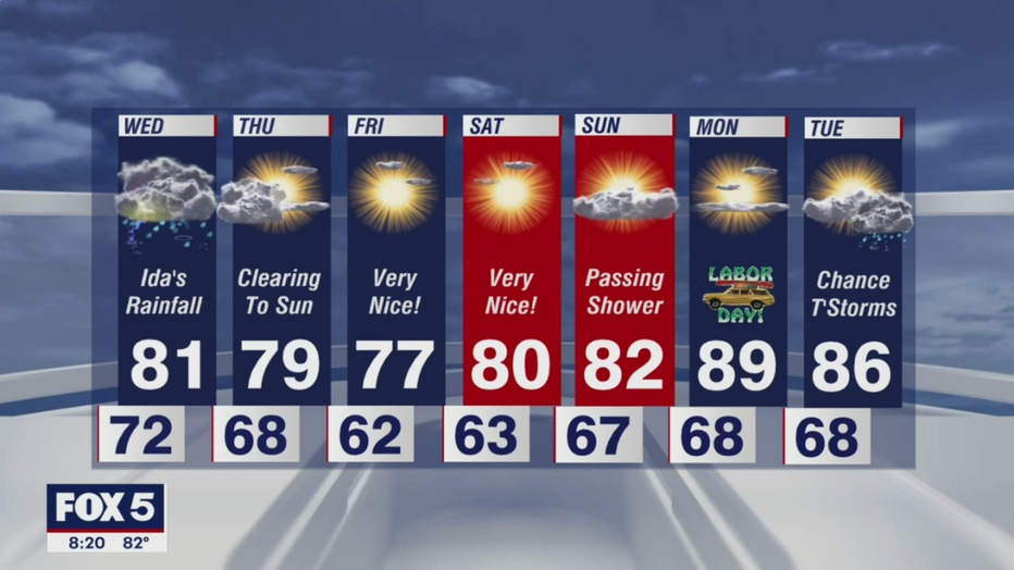
The rain and storms with Ida look to depart early on Thursday and a stretch of beautiful weather will arrive by afternoon into the Labor Day Weekend!