

Florida evacuations underway as major hurricane Ian approaches; Rain may impact DC this weekend

Hurricane Ian approaches Ft. Myers, Florida; Winds reach 120 mph
The National Hurricane Center issued an update on Ian's forecast track Tuesday evening. The major hurricane is now expected to make landfall near Ft. Myers -- south of Tampa.
BETHESDA, Md. (FOX 5 DC) - Hurricane Ian slammed into Cuba early Tuesday morning, knocking out power for over one million people in the western half of the county. Ian later emerged north of Cuba nearly unscathed. As of 6 p.m. Tuesday evening, Ian is a major category 3 hurricane with sustained winds of 120 mph. This is just 10 mph shy of category 4 status.
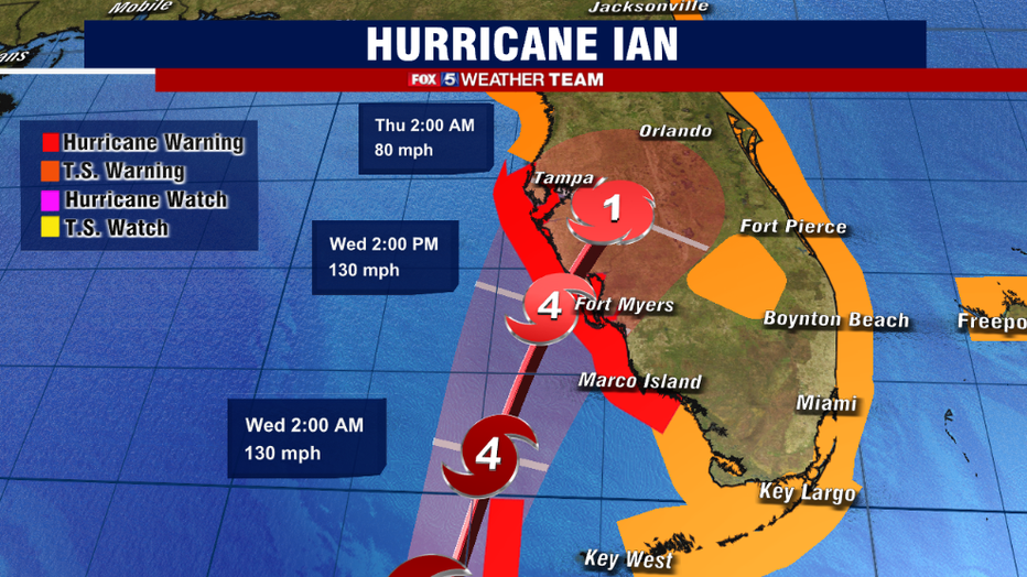
The National Hurricane Center issued an update on Ian's forecast track at 5 p.m. Tuesday evening, expecting landfall now to come farther south than the Tampa area. Even so, major storm surge, wind damage, and heavy rains are expected from Marco Island northward to the Tampa area, where hurricane warnings and evacuation orders remain in effect.
Highways in many locations have been jammed as locals flee coastal zones and push into the interior of Florida, away from the worst of the storm's fury.
Most of the southern half of the Florida peninsula was also placed under a tornado watch this afternoon, as the first of Ian's outer bands brought severe thunderstorms to parts of the sunshine state.
The worst of the weather is expected to occur Wednesday into Thursday as the storm slowly pushes into central Florida.
While it is still expected to weaken slightly from peak strength as it pushes towards the coastline, landfall is still expected at near category 4 strength on Wednesday afternoon.
Widespread power outages are anticipated as the storm impacts the states. Residents are being encouraged to stock up on water and extra batteries for what could be a lengthy repair process after the storm passes.
While the storm should rapidly weaken from peak strength is it pushes into the interior of Florida, coastal regions are expected to take one of their hardest hits from a hurricane in decades.
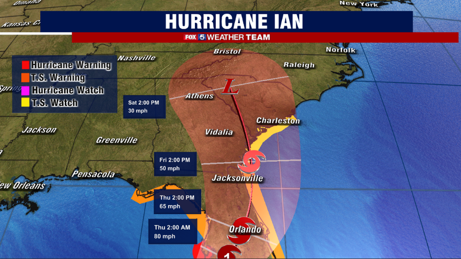
Beyond Florida, weather models this morning have suggested that the storm may fully cross the Florida peninsula and emerge into Atlantic waters near Jacksonville, where it could hold onto tropical storm strength, and have a secondary landfall in the Carolinas.
Tropical storm watches were expanded northward into South Carolina as a result this afternoon. By this stage, strong upper level winds should start to interfere with the structure of the storm. Dry air that has settled in over the Midwest and Northeast will get pulled southward, and wrap around the storm on the western flank.
This should prevent the storm from regaining significant strength even if it does emerge into the warm Atlantic waters off the Georgia and Carolina coastline. Eventually, the storm is likely to become post-tropical, where it no longer has the characteristic of a hurricane or tropical system, but more like those of a nor'eastrer — which can be just as damaging to coastal beaches along the Carolina and Virginia coastlines.
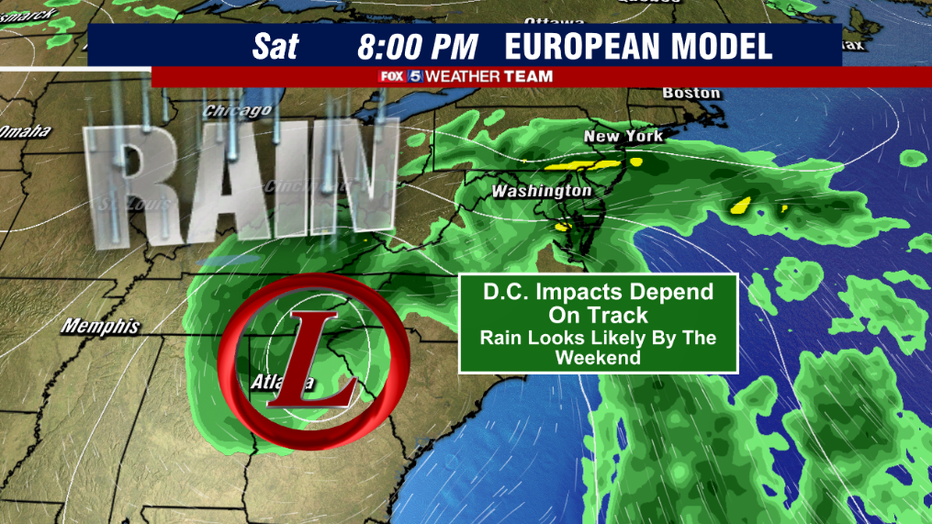
For the Washington, D.C. region, the threat remains primarily a rainfall one. A strong area of high pressure will be entrenched to our north with heavy, dry air settled in over the northeast.
As Ian comes northward, the moisture from the system will be forced up against this dry air mass to our north, which will act like a bit of a road block atmospherically. This will bring the threat for widespread steady and heavy rains across the Mid-Atlantic region, possibly starting as early as Saturday morning.
The short answer on the weekend is that it looks wet, very wet, as things stand this Tuesday evening.
With the storm structure disrupted, we are not anticipating any major concerns from the wind field this far north once Ian's remnants do arrive.
There could be a few gusty days in there, but we are not anticipating tropical storm conditions here in the D.C. area.
Severe weather risks also look to stay at a relative minimum, though we will have to monitor exactly where the central low pressure passes by relative to D.C. for this threat. However, at this time it appears low.
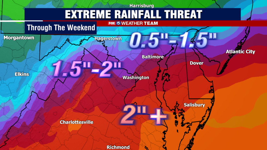
Rains may be heavy enough in some locations that we will likely have to monitor for flooding concerns, especially in some of our southern zones where amounts may exceed two inches.
Details on the weekend forecast will still need to be worked out in the days ahead, but it's not a bad idea to start thinking about those indoor plans now!