

DC area battered by gusty winds, coastal flooding as nor'easter churns north

Nor'easter brings rain, coastal flooding before 80-degree warm-up
Fox 5's Gwen Tolbert tracks a lingering Nor’easter bringing rain, gusty winds, and coastal flooding to the region this Sunday. Expect cool, uncomfortable conditions throughout the afternoon as the system spins off the coast.
WASHINGTON, D.C. - The intense nor'easter roaring up the East Coast is lashing the Washington D.C. area and the broader Mid-Atlantic with relentless wind and heavy rain.

Nor'easter slams East Coast: 1 dead, severe flooding and travel chaos
The storm has packed heavy rain and severe wind gusts, leaving up to 100,000 customers without power and causing major travel disruptions, including widespread flight cancellations.
What we know:
Flooding: The massive storm system continues to trap water along the coast, escalating flooding concerns during weekend high-tide cycles and triggering significant disruptions at major travel hubs down the I-95 corridor.
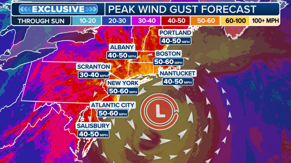
Wind gusts: Across the Mid-Atlantic, wind gusts have reached up to 50 mph, whipping through the region and threatening to bring down branches and power lines. Sustained onshore winds have driven waves dangerously high, preventing normal drainage and causing persistent inundation along coastal and bay communities.
What's next:
While the storm's center is directing its most violent winds toward the New Jersey and New York coastlines, the Mid-Atlantic will continue to feel the squeeze of this powerful autumn system through Sunday.
Peak impacts will gradually subside by Sunday night as wind gusts drop below 40 mph and rain bands weaken. By Monday, the nor'easter will have rapidly lost its strength, leaving behind persistent light rain and lingering high surf that will take several days to fully subside.
The Source: Information from this article was sourced from FOX Weather and the National Weather Service.