

Could DC have a white Christmas? Here are the odds
WASHINGTON - With less than three weeks until the Christmas holiday, the area is aglow with lit trees, homes, storefronts, and displays. It is everything you see on those holiday postcards minus one key element...the Christmas snow. As the famous Bing Crosby song states, "I’m dreaming of a white Christmas"...but just how much of that hope, is in fact, just a dream?

Well, I hate to be the Grinch to your snowy Christmas spirit, but D.C. has never really been a good city for Christmas snow.
READ MORE: DMV Winter 2023-2024 Outlook: Why we're expecting more snow, chance for blizzards in DC this winter
A quick Google search will give you the statistic that around 10% of Christmases here in D.C. feature snowfall. That number, however, is a little on the high side. In fact, going back to when reliable snow records began in 1888, a full 134 years of Christmas snow records, only nine have featured any measurable snow on Christmas.
That’s just under 7% of all Christmases that we have records for.

DMV Winter 2023-2024 Outlook: Why we're expecting more snow, chance for blizzards in DC this winter
With a potentially strong El Niño in play for the 2023-2024 winter season, we're forecasting more snow than an average winter for the Washington D.C. metro, Northern Virginia and Maryland.
Could DC have a white Christmas? Here are the odds
We do not just want measurable snow though, we want good snow! Snow that you can take the sled out on Christmas morning. That Christmas card type snow!
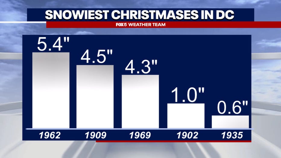
As you may have guessed, this number is even worse. Just three Christmases, about two percent of them, have featured snowfall above one inch here in D.C. Something that last happened back in 1969 when 4.3" of snow fell. You do not have to go back nearly as far for flakes falling. In 2020, rain ended with a brief period of mix/snow on Christmas day.
While a decade prior, back in 2010, it was cold enough that snow flurries were seen in D.C. on Christmas day. You have to go back to 2002 for the last measurable snow on Christmas Day, when the airport picked up just 0.2" of snow. However, considering that the vast majority of D.C.’s average snow comes during the second half of winter, Christmas is just not a very popular holiday for measurable snow as the holiday jingles may have you think.
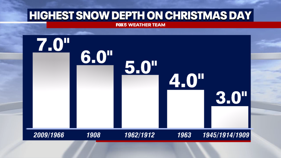
Now, if you consider a white Christmas to just be snow on the ground, the odds are a little more in your favor! Just a hair until 10% of Christmases during this same time period featured more than an inch of snow on the ground. Thirteen years in total.
Most recently, who could forget December 2009, when a monster blizzard dropped over sixteen inches of snow on D.C. on December 19th. It is one of only two cases in over half a century where more than an inch of snow was on the ground on Christmas Day here in D.C. (1989 being the other, with 2" already on the ground)

December as a whole is just not that snowy of a month. Despite being the start of winter, it averages less than two inches of snow total for the entire month, on average here in D.C. Going back to 1888, only about 20% of Decembers feature more than 5" of snow in DC. That number nearly doubles in January. In fact, since that monster blizzard in December 2009, D.C. has only picked up more than an inch of snow in the entire month of December three times. In fact, it has been three years since DC has picked up any snow in December at all! It takes time for cold to settle in, and an active season storm track to set up. Snow is simply much more common is the latter two thirds of winter, as opposed to early winter.
So what about this upcoming Christmas? Are there any hints at whether we will have any chance of seeing any snow around the holidays?
As I am sure you are aware, the farther out in time you go in computer weather guidance, the less accurate they become. Still, there are some factors that we can look at to give us hints. This includes projections of the upper air pattern, as well as other climate signals.
In the short term, there really is not anything to get too excited about in terms of snowfall chances.
The two-week pattern, though, does suggest there is one time frame we need to keep an eye on, and that is centered around next weekend, December 16th and 17th. Some of the better middle range guidance is showing a transient ridge spike over the Pacific Northwest into western Canada that could displace enough cold air eastward to make things interesting, as the pattern remains very active.
This alone does not guarantee a winter storm for our region. With such a progressive, or fast moving pattern, there could be issues with what we call the "cold air supply", where the air that comes eastward is colder than normal, but just not quiet cold enough for snow. We will file this under a "period to watch" but will not bet the farm on it just yet.
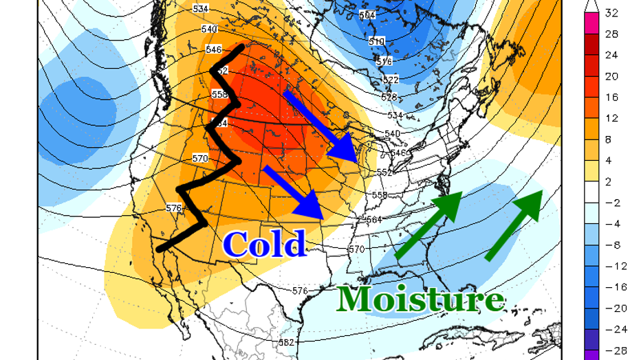
Looking at the week leading up to Christmas, we see that the pattern continues to be progressive. A ridge over the Northeast is backing northward, into Canada. This will likely be coupled with another storm that will "fill the gap" that the atmosphere leaves as this shift occurs in the days ahead of Christmas, somewhere in the eastern half of the country.
High pressure weakening in the Pacific Northwest should buckle the polar jet stream southward across the middle of the country while a strengthened subtropical jet stream carries moisture northward. It is probably going to be a rainmaker for our region, but we will keep an eye on how the pattern evolves. I would not say I am overly excited about our snow prospects in the days before Christmas.
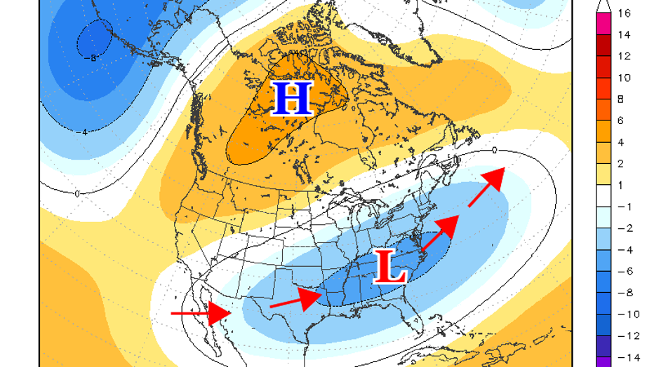
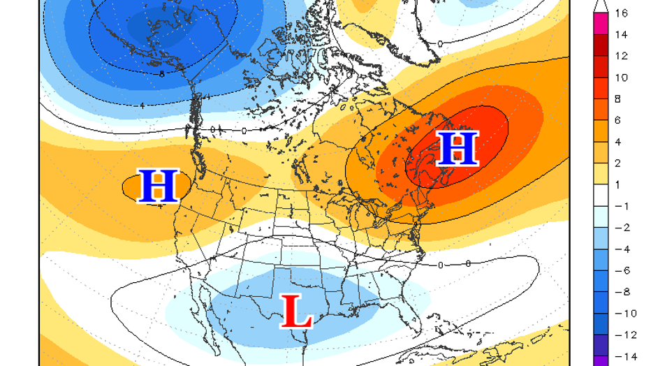
As we get towards Christmas Day and the week leading up to New Years, things become a little more interesting. The upper ridge lifts and retrogrades back into Northwest Canada. This is key, because an upper ridge here displaces cold air downstream, to the south and east. At the same time, a vigorous subtropical jet stream shifted eastward, carrying moisture and keeping the storm track active, but this time across the eastern half of the country. This could be the precursor to what could be a period of active wintry weather.
While there are never any guarantees in this range, the long range guidance is hinting at this period being when the pattern shifts in a more favorable way for winter weather in the D.C. region. Could it be as early as Christmas? Absolutely. But since guidance like this tends to rush pattern shifts, it is more likely to occur after Christmas Day.
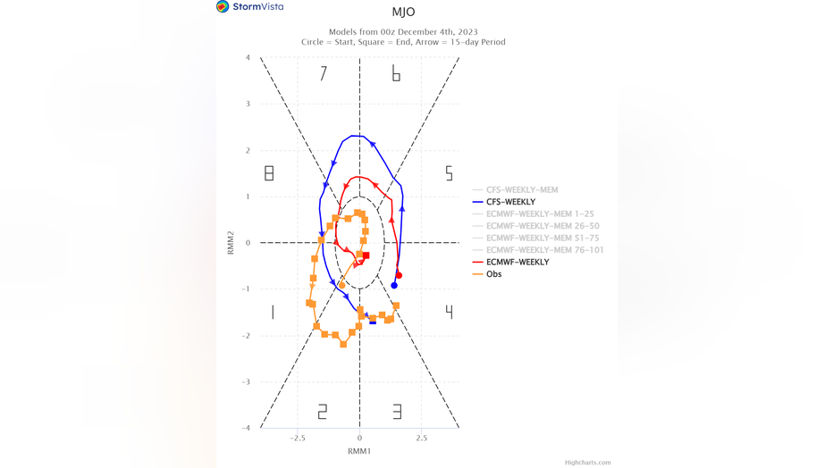
Once the pattern does settle in though, the guidance does suggest it may lock in through the first half of January ahead. A hint that this may indeed be the case, is a climate signal that forecasters watch closely, known as the Madden-Julian Oscillation, or MJO.
The MJO cycles through eight phases (or is in a neutral setting) and is a measure of large regions of enhanced and suppressed tropical rainfall, mainly observed over the Indian and Pacific Ocean. The exact location of these areas of upward and downward motion can heavily influence global weather patterns, and are one of the best predictors of long range weather that we have.
In the chart above, you can see it is forecast to rotate through several phases, with the key being near the end of the cycle, when you see it swing through phases eight, one, and two. These phases all favor colder air in the eastern United States.
The question of whether or not it will bring snow or not remains to be seen! But at this time, the signal are out there that our region is in for a big shift sometime around or just after the Christmas holiday.
We will continue to monitor any winter risks for you as the holidays approach, and will continue to update you in the weeks ahead!