

How much snow is expected? Confidence building for ‘double trouble’ winter storm Sunday and Monday
WASHINGTON (FOX 5 DC) - It has been some time since the last inch of snow fell in Washington, D.C. – over 700 days in fact.
Last year was the winter that wasn't here in our region, failing to pick up not an inch of snow from one storm, but less than an inch of snow the entire season for only the third time in the city's history.
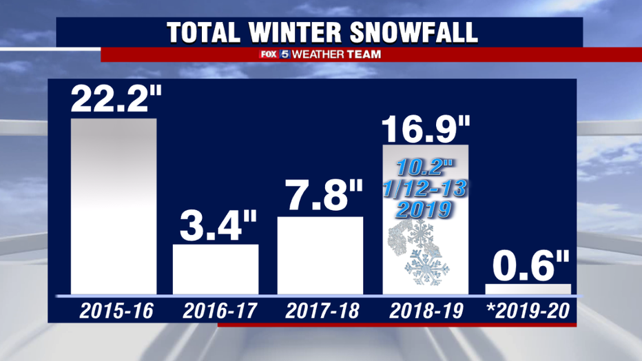
This year has not been off to a great start for Reagan National either has the airport had only picked up 0.3" of snow this winter so far.
You have to go back to February 2019 for the last time D.C. got over 1" of snow, and back to January of that same year for the last winter storm for the city.
DOWNLOAD THE FOX 5 WEATHER APP
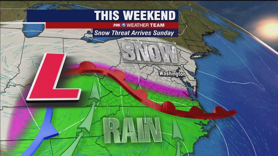
This upcoming winter storm will be divided into two parts. The first part of the storm system is the part we have more confidence in, as models are in general agreement on how it will play out.
It is a process we call overrunning, where warm, moist air runs into cold, dry air and is forced to rise, condense, and fall as snow.

How much snow is expected? Confidence building for ‘double trouble’ winter storm Sunday and Monday
FOX 5’s Mike Thomas has a look at the winter weather forecast that is expected to bring snow to the D.C. region Sunday and Monday.
The snow is forecast to approach our region early on Sunday morning, overspreading the region from southwest to northeast between sunrise and the noon hour.
HOW MUCH SNOW? DEVIL IN THE DETAILS FOR POSSIBLE WINTER STORM SUNDAY AND MONDAY
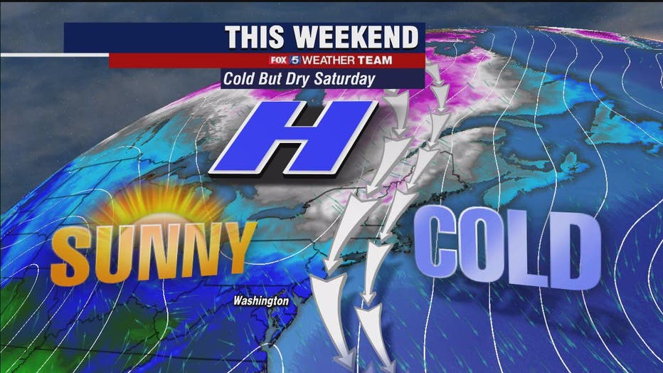
Snow is likely to fall at a light but steady pace, with temperatures Friday and Saturday expected to be some of the coldest of the winter season. The ground will be ready to accumulate any winter precipitation that happens to fall.
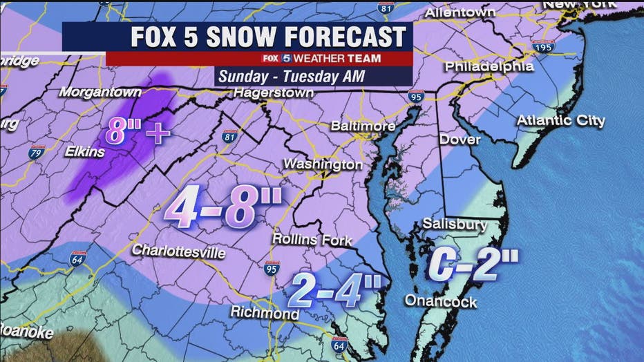
A Winter Storm Watch has been issued for much of the D.C. region on Sunday.
Various weather models have been pretty consistent with widespread snowfall amounts, with a blanket of 2-5" snowfall amounts nearly region-wide with the initial push of snow through the day on Sunday.
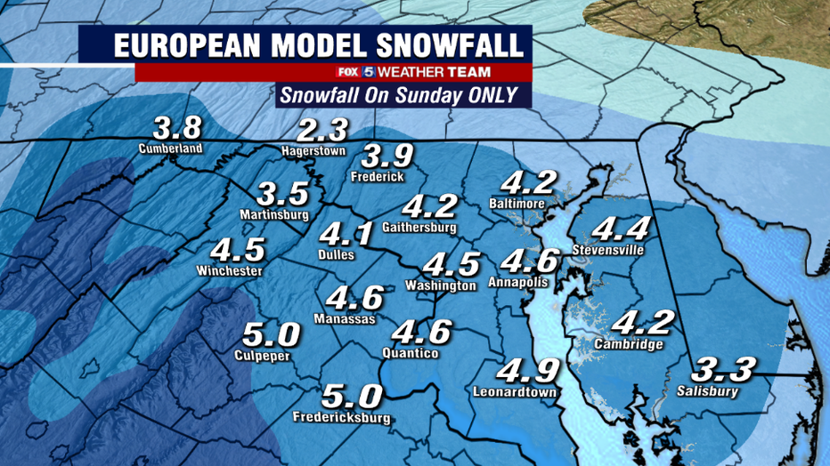
The European is the more aggressive of the snowfall guidance this morning because it shows little mixing on Sunday afternoon, leaving it as mostly a snow event before the snow settles down and the region potentially sees a break by the evening hours Sunday night.
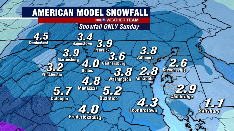
The American model shows similar 2-5" amounts across the area on Sunday, but does differ in the fact that is shows more mixing with some rain and sleet by the afternoon hours into the evening, which would help cut back on totals region-wide.
One of the few debates that still remain for Sunday is just whether or not this mixing will actually occur, but confidence is high that the event will at least start as snow and that several inches are likely to fall.
After a bit of a lull in the action on Sunday night into the very early hours of Monday, part two of the storm will get underway as a coastal storm system begins to develop to our south and east.
It is this part of the storm where models remain divided.
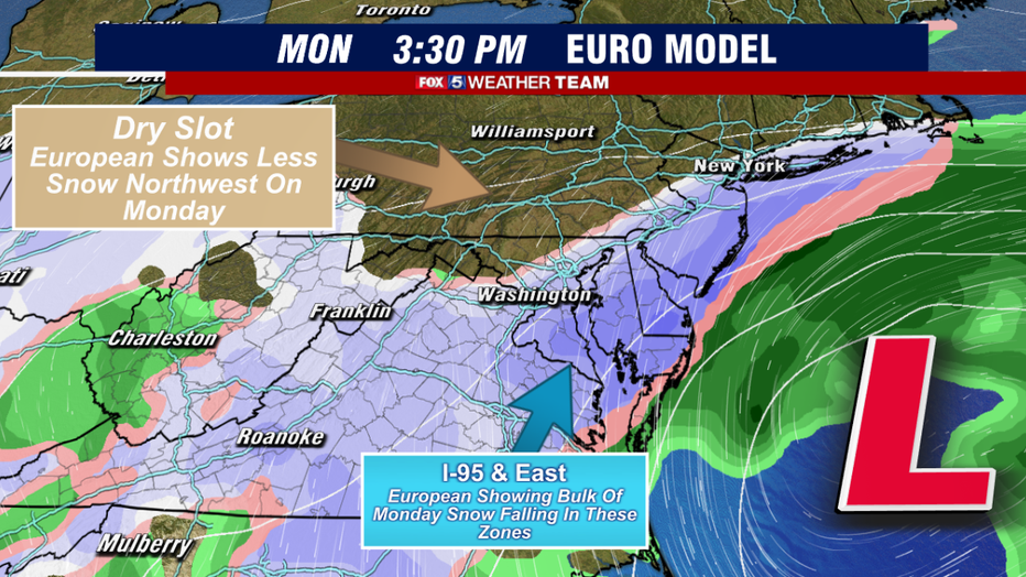
Friday morning's European model for example shows snow redeveloping through Monday morning into the afternoon with the heaviest snow bands setting up along the I-95 and areas to the east... something that is actually pretty rare for coastal systems like this.
In fact, it shows northwestern areas actually battling with a lot of dry air and picking up very little additional snowfall.
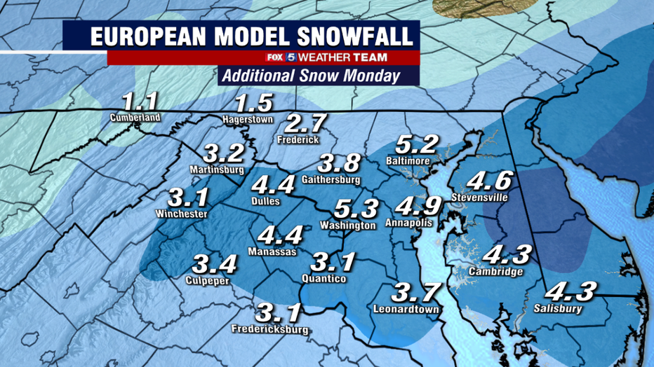
Notice how that is reflected in the above image, showing just the additional snow the European model is putting down on Monday. Eastern zones get more, western zones get less.
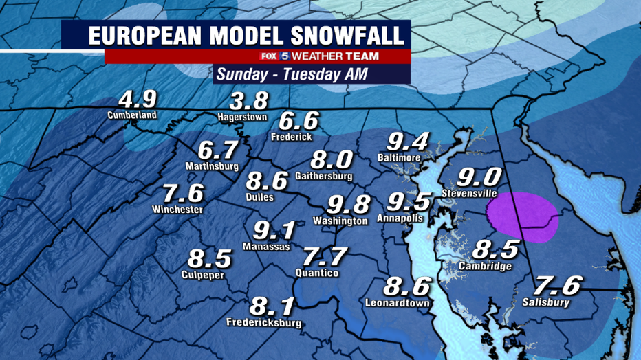
Putting together both the Sunday and the Monday parts of the system, the total forecast snowfall for this prolonged winter storm event.
The most interesting thing to note is something that does not happen too often in our region which is more snow south and east as opposed to the more typically seen higher totals in the northern and western zones.
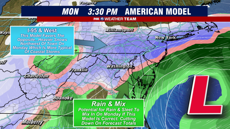
By contrast, the American model shows more of the classic Nor'easter set up on Monday afternoon, with the rain/snow line dancing between Southern Maryland and the I-95 corridor while northwestern areas see the heaviest snow bands develop as the storm strengthens on Monday afternoon.
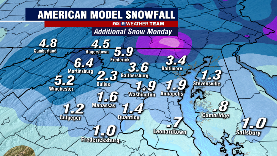
With the model showing more mixing to the southeast with the Monday portion of the system, the model is a lot less aggressive with snowfall amounts in these regions. Notice that the model shows the more classic higher totals in the northwest zones.
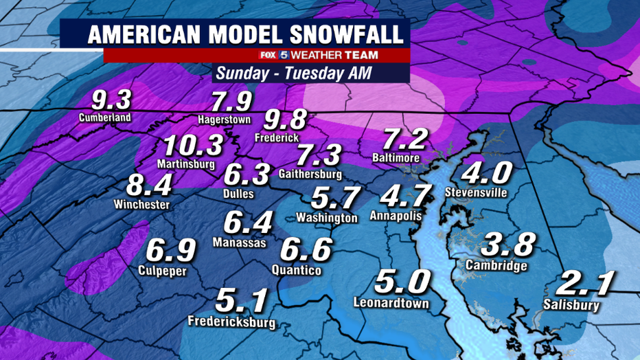
So when we look at the American model total for both the Sunday and the Monday event combined, it shows more of almost what we would expect to see from any coastal winter storm in this region, and that is higher amounts off to the northwest of town.
To summarize, we expect that snow will overspread the region on Sunday, starting in the morning hours. Several inches will likely fall, because our region either sees a break or some light mixing of sleet or rain into the evening hours.
Snow is then expected to redevelop in parts of the region on Monday, but at this time we are still unsure about who is going to have the best shot at getting the heavier snow bands on Monday afternoon. We will have to keep an eye on weather models over the next couple of days to hammer out the details there.
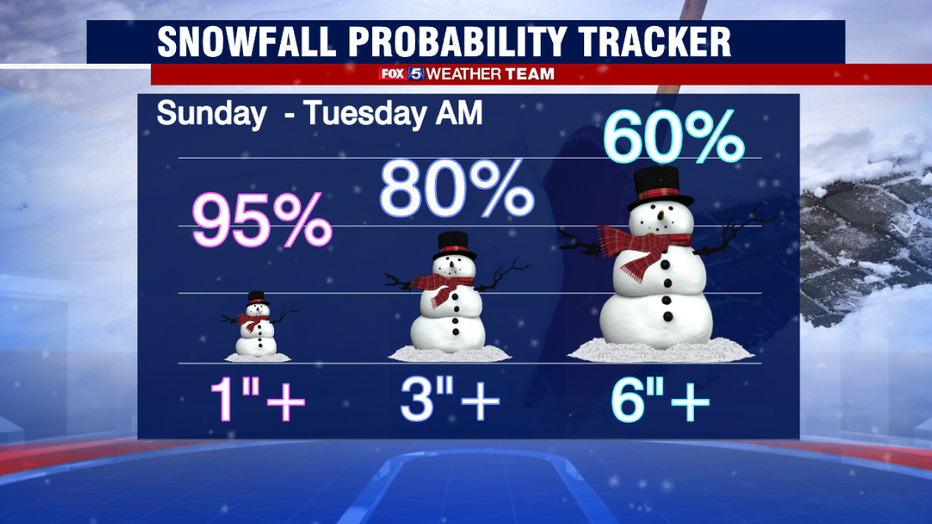
The system should wrap up an exit our region later on Monday night or into the early morning hours of Tuesday. As things stand as of this moment, we have reasonable model agreement to believe that at least 4-8" of snow will be possible with this system by the time it exits our region, with a "boom threat" of 8-12" certainly possible.
Travel will likely be treacherous in the region as very cold ground temperatures will allow the snow to stick quickly when it does fall.
Keep it tuned to FOX 5 all weekend long for updates on what could be DC's biggest snowfall in about two years! And do not forget about that free FOX 5 Weather App! The best way to track the storm as it pushes into our region.
Stay with FOX 5 on the app and online for weather updates:
Get the latest FOX 5 forecast here.
Check the latest Closings and Delays
Download the FOX 5 DC News App for Local Breaking News and Weather
Download the FOX 5 Weather App
Check the latest weather radars
Stay up to date with the FOX 5 Weather Team on Twitter: