

Winter Outlook: No Major Blizzards, But Above Normal Snowfall Is Possible This Winter across the DMV

Winter Weather Outlook Forecast 2022-2023
FOX 5’s Tucker Barnes takes a look at much snow the D.C. region could see this winter!
As holiday commercials begin to play on TV; Mariah makes it clear that Halloween is over; and Starbucks trots out its red cups - thoughts quickly are turning to snow. But, how much snow? Let's explore.
2022 Winter Outlook Highlights
- Expecting Similar Levels Of Snowfall To Last Winter, Perhaps A Little More In The Immediate D.C. Area With 9-18" Of Snow.
- One To Three Winter Storm Events, We Are Once Again Calling For No Blizzards As The Risk Of A Significant Blizzard Remains Very Low.
- Periods Of Cold, But Expecting Winter Temps About One To Three Degrees Above Normal.
- Fading La Niña Late Winter Should Bring Increased Snow Risks Second Half Of The Season.
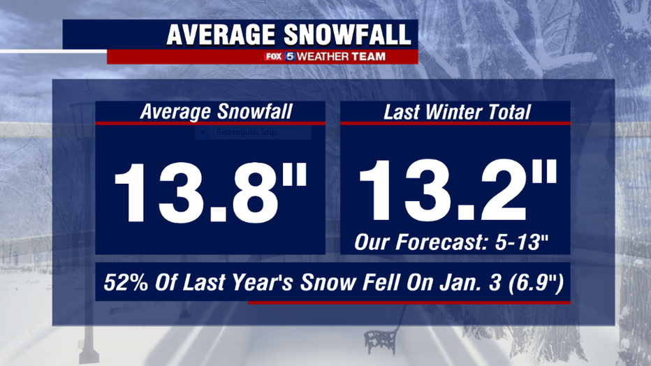
Last Winter Forecast In Review
The screaming messages with last winter's forecast was expecting a below normal snowfall season, no blizzards, and above normal temperatures. We forecasted 5-13" of snow and ended up with a hair over 13" at Reagan National Airport. As a whole, the city only had one moderate snow event that accounted for more than half of the snowfall for the entire season, when nearly 7" fell on January 3rd. This storm was infamous when drivers along I-95 in Virginia became stranded for nearly a full day due to poor snow removal planning. For only the fourth time since the turn of the century, the month of February came in without any measurable snow being recorded in the Washington, D.C. area. Northwest areas suffered even more snowfall wise, with many getting well-below normal snowfall for the season. With La Niña in full swing across the Pacific, temperatures averaged more than 2° above normal for the winter months. Overall the forecast got the core themes correct last winter - with just a touch more snowfall than expected.
Factors This Year
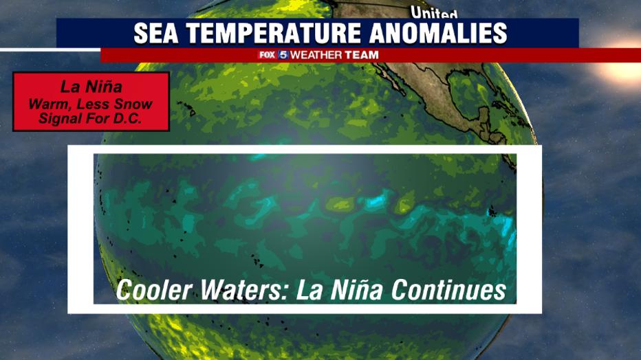
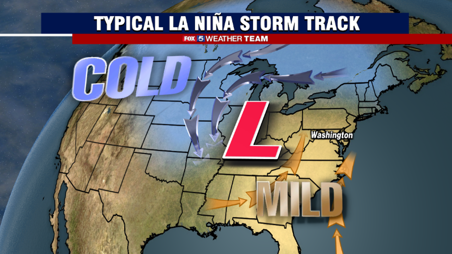
By far the biggest factor you always hear about for seasonal forecasting is the classic La Niña or El Niño pattern. La Niña is characterized by cooler than normal water temperatures across the equatorial Pacific. While a complicated weather feature, the short story is that temperature differences in the ocean can influence the global wind patterns, which subsequently impact how weather features behave over North America. We are currently in the midst of a prolonged La Niña pattern. The previous two winters have both been classified as moderate La Niña, and for a third straight winter, forecasters and climate models agree…we are in for another La Niña winter. A typical La Niña pattern is often defined by milder than normal conditions across the southern and eastern United States, while the coldest conditions of winter get locked up across the interior of the country.
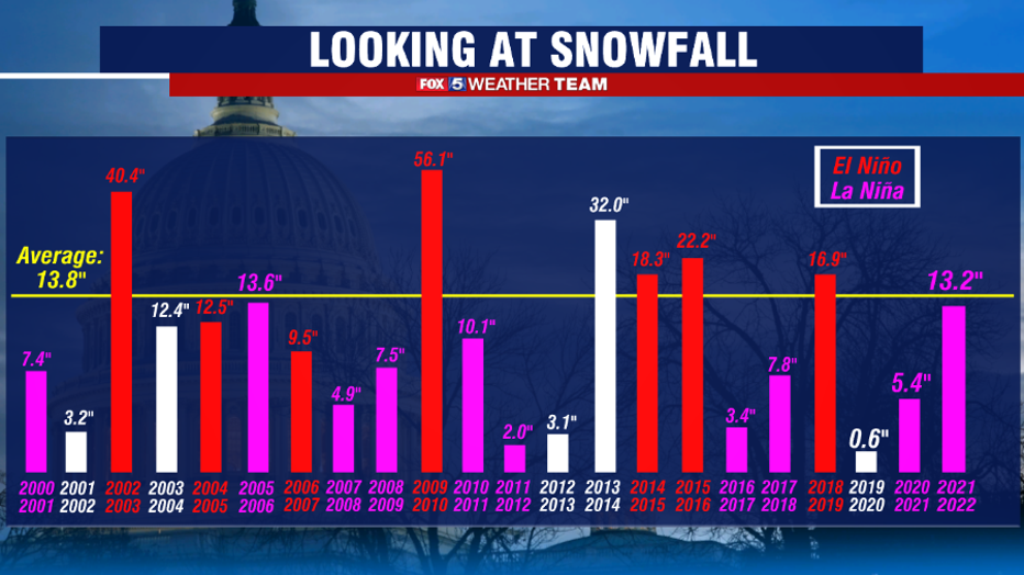
What is interesting about La Niña is just how telling of a predictor it can be for snowfall in our region. Since the turn of the century, there have been 10 La Niña winters, and not a single one has brought our region above normal snowfall, even with average snowfall falling by over half an inch when 30 year normals were updated. Not a single La Niña winter since 2000 has accomplished this feat. In fact, if you go back even farther, to 1950 when the meteorology community started more closely tracking El Niño and La Niña and its impacts on the North American climate, only one single La Niña winter has produced more than 17.1" of snow in our nation's capital.
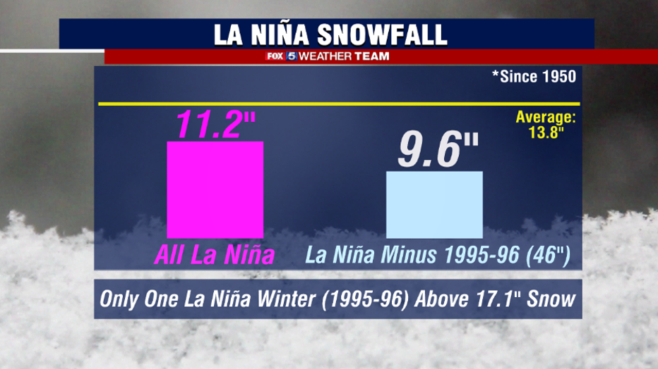
That year was 1995-1996, which remains the third-snowiest winter in D.C. history with 46" of snowfall, the vast majority of which fell during the Great Blizzard of January 1996. It is such an anomaly in the data, that when it is excluded from other La Niña winters, the average snowfall drops by nearly two full inches. As such, when I write these winter outlooks, I tend to throw it out as far as including it in a typical La Niña winter. It does bring up one good point though, and that is that a blizzard IS possible during a La Niña winter. However, they are considerably rarer than during their El Niño counterparts. So we are not favoring a major blizzard this upcoming winter. It's not impossible, but the history suggests we will have a better opportunity in other winters. Without this one extreme winter, you can see that the typical La Niña winter averages less than 10" of snow. And that's why we are not expecting any sort of blockbuster winter in terms of snow this year - the data just shows it is very unlikely.
We never only look at one factor for our winter outlook. Other factors that play a large role in our winter outlook include the speed with which Siberia snow pack expands through the fall months, a feature known as the Snow Advance Index. This appears to be running around normal to a little below normal, which research suggests can be inductive of less intense cold across the eastern half of the United States. We also track how active the sun is, with increased sunspot activity indicating a more active solar pattern than we have been in the previous several winters, with activity even running well above projections, suggesting we are well into our 25th solar cycle with solar activity expected to continue to ramp up through the summer of 2025. Research suggests that increased solar activity can favor less sustained cold air outbreaks and therefor milder conditions overall in the winter. In addition to the Tropical Pacific, we also track sea surface temperatures across the Northern Atlantic and Northern Pacific oceans. On the Pacific side, ocean temperatures remain warmer than normal south of the Bering Sea with average to cooler than average waters known as a negative Pacific Decadal Oscillation, or -PDO for short. A -PDO pattern favors warmer than normal conditions across the eastern half of the country, with cooler than normal conditions in the west.
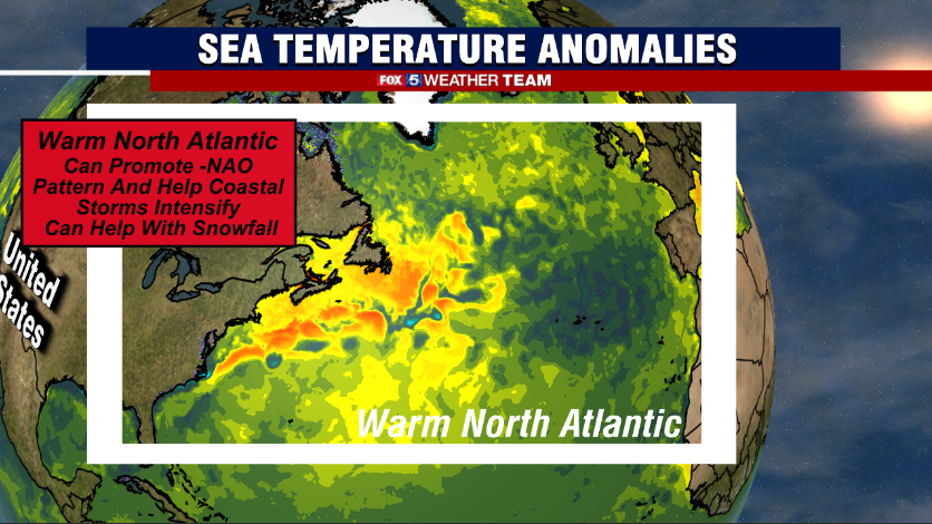
So if you are keeping track, in addition to La Niña, that is three other factors that are leaning towards a milder, and less snow filled winter. Many of these were present in the previous winters as well, and both of those winters did in fact end up with below normal snowfall for Washington, DC. In fact, our last above normal winter for snowfall was all the way back in 2018-19. The one area that could help us out is the warmer than normal water temperatures in the North Atlantic. Well above normal waters off the Northeast Coast could lead to rapidly intensifying storms in the region and 50-50 upper low development, which is a key feature needed for Mid-Atlantic snowfall. Warmer waters around Greenland could also promote a blocking feature known as a negative North Atlantic Oscillation, or -NAO for short. This feature often helps push cold air southward into the eastern half of the United States, while helping steer storms on a more southern and eastern track which is better for snow for our region. Another thing to consider is that while La Niña is expected to start the winter, it is expected to weaken through the duration of the winter and into early next spring. This could allow for a more volatile winter the second half of the season and into early spring. All this being considered though, we do not believe this is strong enough to overcome the other features at play this winter though, and so are favoring an above normal winter overall in terms of temperatures.
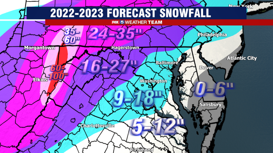
The Winter 2022 Forecast: 9-18 Inches for the DC area
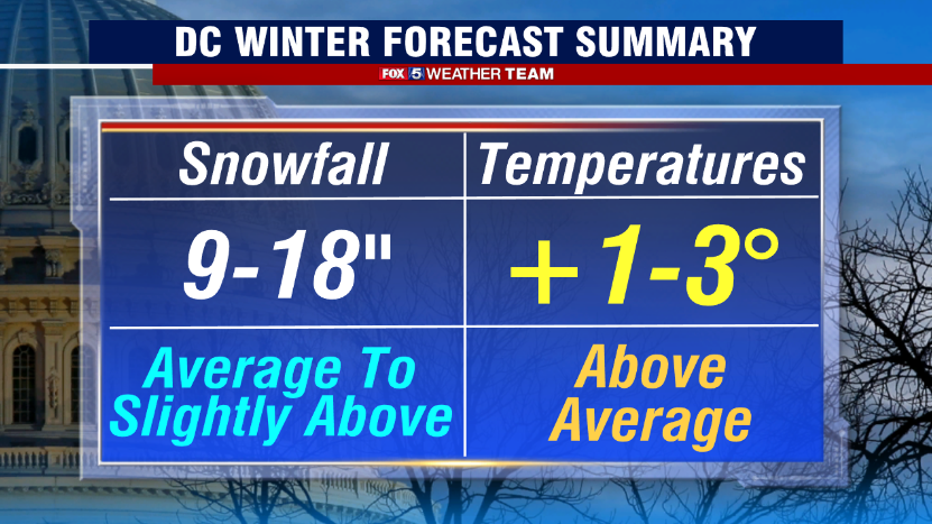
And with that, let us get into the details of what we are expecting this winter. The disclaimer first: no winter forecast is going to be perfect. It is a combination of science and statistics, and no two winters are ever the same. With that being said, based on the analysis, we are expecting 9-18" of snow this season for the immediate area. This is about the same as last year, but I believe the potential will be there for a little more snow compared to last winter given that La Niña is forecast to fade as we get deeper into winter. If this does not happen as fast as climate models suggest, it's more likely that we end up towards the lower end of our range. Another above normal winter temperature wise is expected as well, though we are not anticipating anything close to record-breaking when it comes to overall winter warmth. There will be periods of cold, but their longevity will likely be limited, particularly later in the winter.
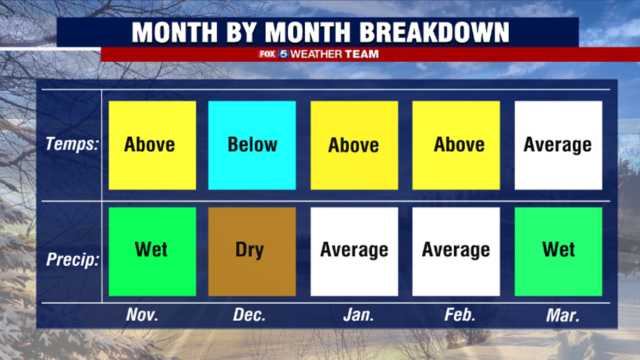
November is already off to a very warm start, and while we believe the later part of the month will see a pattern change that will bring in some cooler weather, we don't expect it will be cold enough to outweigh the warm start. That being said, we do think that December will begin on a colder note that could keep us chilly though the holidays. January and February will be battle months, back and forth between "seasonally mild" and cold. We believe in the end though that these months will both verify above normal in this category. Precipitation should be more active the latter half of the winter, as La Niña weakens and the storm track becomes more favorable for the region. I am expecting less snow in January compared to last year (12.3") with more snow expected in February (Trace) compared to last year.
With these winter expectations, we expect the second half of winter to be busier in terms of snowfall than the first, which is typical in the majority of winters. Eight-six percent of our average snowfall here in D.C. falls between January and March. December, while typically the first month for measurable snow for the city, it typically quieter for more extreme snow events. In total for this winter we are forecasting between one and three winter storm level events, or events where 5" or more of snow is possible, and are once again calling for no major blizzards this year. The mountain zones, specifically those westward facing slopes, should have a better winter compared to last season and above normal snowfall is more favored in those areas given the favored inland storm track.

And there you have it. Your FOX 5 Weather Forecast for the winter ahead! Now look, this forecast will undoubtedly be less than perfect as seasonal forecasting is notoriously difficult, as no two winters are exactly the same. This one will contain its own surprises, and we will be here to help you through them every step of the way. I do want to end on a positive note for those that do not enjoy the cold or the snow as much as some others in our region. Similar to last year, the data suggests that we should have a timely start to spring next year.
Winter officially begins on December 21st!