

Despite cool midweek, a June heatwave looms
WASHINGTON - Considering the Washington, D.C. region was dealing with 90s as early as late April this year, early June has gotten off to a relatively tame start as far as temperatures are concerned. Through nearly the first third of the month, temperatures have been running close (just 1 degree above) the seasonal average. This has been due in large part to rain and thunderstorms which at times was persistent in the region through the second half of May and into early June.
The rains were beneficial as they erased the region's drought that carried over from an abnormally dry winter season; however the pattern is about to shift to a drier and much hotter setup as we head into the middle portion of June.
It will all start this weekend as a strong area of high pressure forms over the eastern Atlantic - a feature known as a Bermuda high. These big, slow moving areas of sinking air promote calmer weather conditions and sunshine. Winds rotating clockwise around the center of these high pressure areas bring up both tropical heat and moisture from the southern states. This feature has already visited us twice before, once with the 90s to end the month of April and then again with a string of 90 degree days in the middle of May. When these features appear during the summer months, when day length and therefore sunlight are at their longest period of the year, the region can experience some of their most extreme heat waves.
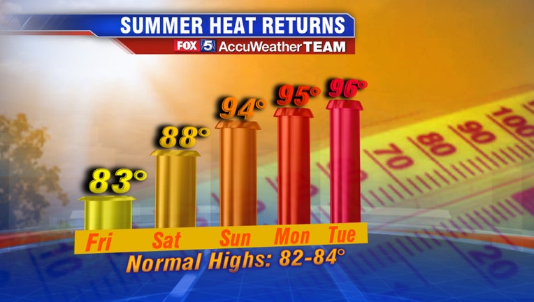
Current weather model guidance suggests we are looking at a multiday heat wave event heading for the region early next week. After a cooler and cloudier midweek this week (enjoy it…), 80s return to the region beginning Friday afternoon. By Saturday, high temperatures will be on the verge of 90 degrees across parts of the D.C. region, with more widespread 90s expected by Sunday afternoon. The core of the heat arrives Monday to Wednesday of next week, with humidity getting progressively worse each afternoon. Record high temperatures may be threatened as well, primarily on Monday and Tuesday where records are currently in the middle 90s. By Wednesday, the "feels like" temperatures in Washington, D.C. may be pushing or over 100 degrees for the first time this year. Beyond Wednesday, weather models differ on which day the heat breaks. The American suite of models breaks the hot pattern with a round of thunderstorms on Thursday afternoon, while the European suite of models carries the heat through until Friday.
Reaction to the heat is always mixed for our region. Some cannot stand it (we're looking at you Tucker Barnes!) while others are just fine with taking advantage of the heat to hop in the pool or head to the beach. Regardless of which camp you fall under, it is important to take the proper precautions for summer heat waves. Statistics from the National Weather Service show that heat is the deadliest form of weather in the United States - more so than tornadoes, hurricanes, lightning, etc. It is important to make sure you are taking proper precautions to make sure both you do not become a victim to heat related illness. Take care of your furry friends as well and NEVER leave pets of any kind inside of a car on a hot day. For those in the District, remember that a Heat Emergency is declared anytime the air temperatures or the heat index ("feels like" temperature) exceeds 95 degree, which is likely to happen several times through the first half of next week. This means that D.C. will open additional cooling centers around the metro region, which you can find a full list of on their website HERE.